Africa (Southern Sheet): Colton 1855
-
Title: Africa (Southern Sheet)
- Author: J. H. Colton
- Date: 1855
- Medium: Hand-colored lithograph
- Condition: Good - age toning, light foxing, fragile paper
- Inches: 17 x 14 [Paper]
- Centimeters: 43.18 x 35.56 [Paper]
- Product ID: 318077
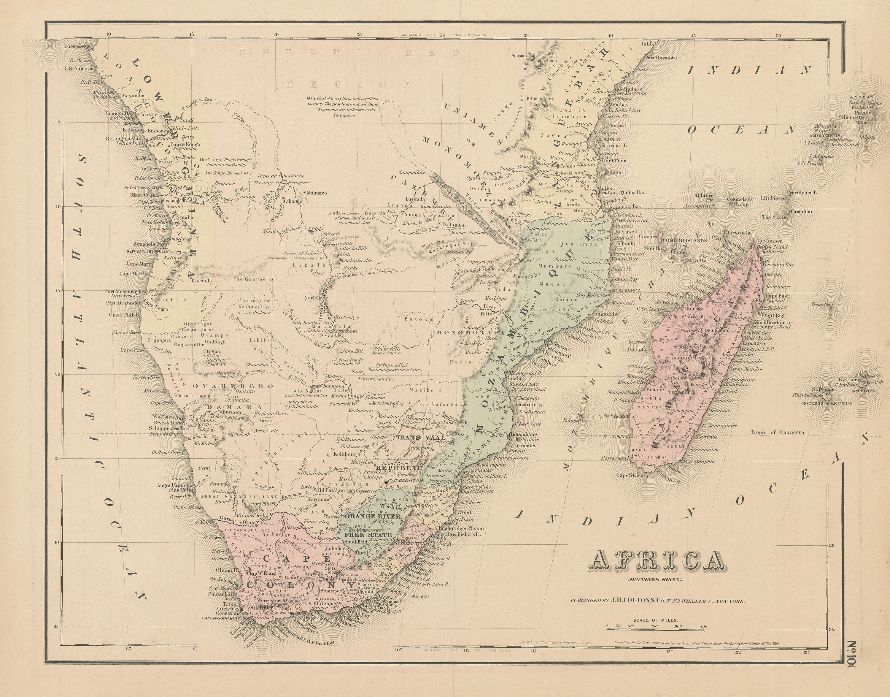
Map of south Africa labeling various nations and European colonies. Includes the Cape of Good Hope and the island of Madagascar. Marks various cities, topographical features, and information about the region's Native people.
Joseph Hutchins Colton (1800-1893) moved to New York City from his birthplace of Longmeadow, Massachusetts to start the J.H. Colton Company in 1831. Though he did not come from a cartographic or engraving background, Colton licensed copyrights from other cartographers such as David H. Burr and Samuel Stiles, producing quality reprints with additional engraving and border detail. After ten years of operating with this business model, Colton branched out to produce original maps, and by the 1850s had grown his company into a booming cartographic firm. Though the Colton Company published a variety of cartographic materials such as guidebooks and atlases, it is perhaps best known for its railroad maps. Distinguished by their elaborate decorative borders, Colton maps were printed using engraved steel plates which, though more costly than wax engravings, produced higher-quality images. These maps were then hand-colored by watercolor artists, resulting in slight irregularities which reflect the documents’ unique history and individualized production.
Notable moments in Colton’s career include winning a high-profile lawsuit against the government of Bolivia, by whom he had been hired to produce some 2,500 maps of the region in 1857. When he did not receive pay upon completing his contract, mostly due to Bolivian civil unrest, Colton took legal action and eventually received $100,000 in compensation.
Colton’s sons George Woolworth Colton (1827-1901) and Charles B. Colton (1832-1916) joined the company in the early 1850s; when the two eventually took over from their father, they renamed the firm to G.W. & C.B. Colton. A few years later in 1898, the brothers went into business with August R. Ohman, renaming the firm again to Colton, Ohman, & Co. This relationship lasted until 1901 when the Coltons left the company and Ohman took over in full, subsequently dropping the Colton name.
-
Title: Africa (Southern Sheet)
- Author: J. H. Colton
- Date: 1855
- Medium: Hand-colored lithograph
- Condition: Good - age toning, light foxing, fragile paper
- Inches: 17 x 14 [Paper]
- Centimeters: 43.18 x 35.56 [Paper]
- Product ID: 318077
Map of south Africa labeling various nations and European colonies. Includes the Cape of Good Hope and the island of Madagascar. Marks various cities, topographical features, and information about the region's Native people.
Joseph Hutchins Colton (1800-1893) moved to New York City from his birthplace of Longmeadow, Massachusetts to start the J.H. Colton Company in 1831. Though he did not come from a cartographic or engraving background, Colton licensed copyrights from other cartographers such as David H. Burr and Samuel Stiles, producing quality reprints with additional engraving and border detail. After ten years of operating with this business model, Colton branched out to produce original maps, and by the 1850s had grown his company into a booming cartographic firm. Though the Colton Company published a variety of cartographic materials such as guidebooks and atlases, it is perhaps best known for its railroad maps. Distinguished by their elaborate decorative borders, Colton maps were printed using engraved steel plates which, though more costly than wax engravings, produced higher-quality images. These maps were then hand-colored by watercolor artists, resulting in slight irregularities which reflect the documents’ unique history and individualized production.
Notable moments in Colton’s career include winning a high-profile lawsuit against the government of Bolivia, by whom he had been hired to produce some 2,500 maps of the region in 1857. When he did not receive pay upon completing his contract, mostly due to Bolivian civil unrest, Colton took legal action and eventually received $100,000 in compensation.
Colton’s sons George Woolworth Colton (1827-1901) and Charles B. Colton (1832-1916) joined the company in the early 1850s; when the two eventually took over from their father, they renamed the firm to G.W. & C.B. Colton. A few years later in 1898, the brothers went into business with August R. Ohman, renaming the firm again to Colton, Ohman, & Co. This relationship lasted until 1901 when the Coltons left the company and Ohman took over in full, subsequently dropping the Colton name.
Original: $100.00
-65%$100.00
$35.00Description
-
Title: Africa (Southern Sheet)
- Author: J. H. Colton
- Date: 1855
- Medium: Hand-colored lithograph
- Condition: Good - age toning, light foxing, fragile paper
- Inches: 17 x 14 [Paper]
- Centimeters: 43.18 x 35.56 [Paper]
- Product ID: 318077
Map of south Africa labeling various nations and European colonies. Includes the Cape of Good Hope and the island of Madagascar. Marks various cities, topographical features, and information about the region's Native people.
Joseph Hutchins Colton (1800-1893) moved to New York City from his birthplace of Longmeadow, Massachusetts to start the J.H. Colton Company in 1831. Though he did not come from a cartographic or engraving background, Colton licensed copyrights from other cartographers such as David H. Burr and Samuel Stiles, producing quality reprints with additional engraving and border detail. After ten years of operating with this business model, Colton branched out to produce original maps, and by the 1850s had grown his company into a booming cartographic firm. Though the Colton Company published a variety of cartographic materials such as guidebooks and atlases, it is perhaps best known for its railroad maps. Distinguished by their elaborate decorative borders, Colton maps were printed using engraved steel plates which, though more costly than wax engravings, produced higher-quality images. These maps were then hand-colored by watercolor artists, resulting in slight irregularities which reflect the documents’ unique history and individualized production.
Notable moments in Colton’s career include winning a high-profile lawsuit against the government of Bolivia, by whom he had been hired to produce some 2,500 maps of the region in 1857. When he did not receive pay upon completing his contract, mostly due to Bolivian civil unrest, Colton took legal action and eventually received $100,000 in compensation.
Colton’s sons George Woolworth Colton (1827-1901) and Charles B. Colton (1832-1916) joined the company in the early 1850s; when the two eventually took over from their father, they renamed the firm to G.W. & C.B. Colton. A few years later in 1898, the brothers went into business with August R. Ohman, renaming the firm again to Colton, Ohman, & Co. This relationship lasted until 1901 when the Coltons left the company and Ohman took over in full, subsequently dropping the Colton name.