Big Bend National Park: U.S. Geological Survey, 1971
- Title: Big Bend National Park
-
Author: U.S. Geological Survey
- Date: 1971
- Condition: See description
- Inches: 39 3/4 x 33 7/8 [Image]
- Centimeters: 100.96 x 86.04 [Image]
- Product ID: 308669
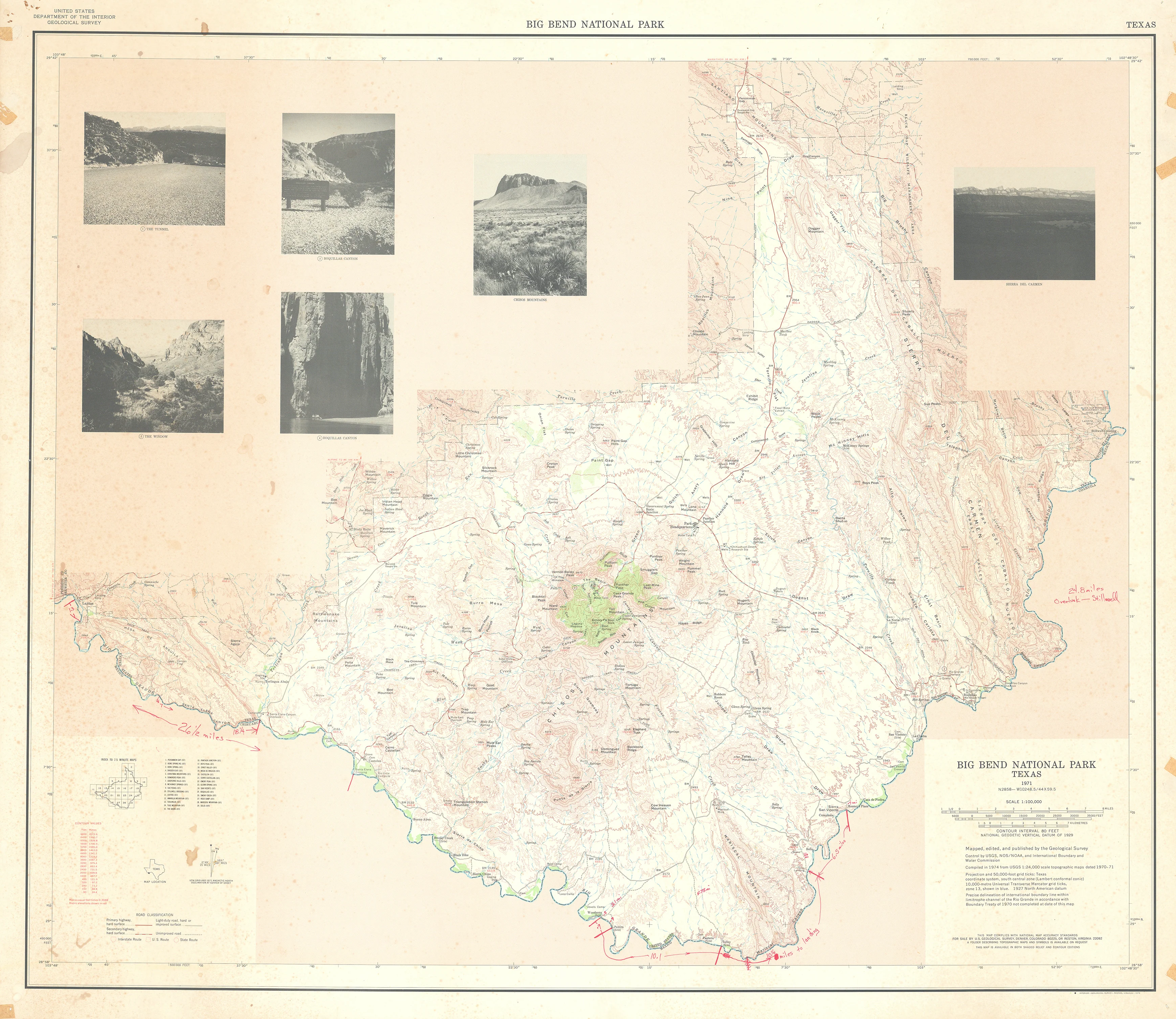
This large mid‑twentieth‑century United States Geological Survey sheet of Big Bend National Park, Texas, presents the entire park in a single, exhibition‑style composition that fuses precise topographic science with interpretive visual narrative, its large central panel rendering the mountainous desert landscape in subtle hypsometric tints and finely engraved contour lines draped over meticulous shaded relief so that the Chisos Mountains, deep canyons, and broad alluvial basins rise convincingly from the page while the sinuous Rio Grande, traced along the southern edge, anchors a dendritic network of tributary arroyos that cut back into plateau and basin alike, revealing the erosional architecture of the region. Around and within this physiographic framework, red‑toned linework and symbols delineate the cultural infrastructure of the park—paved and graded roads, unimproved tracks, boundary lines, ranger stations, developed areas such as the Chisos Basin and Rio Grande corridor, and a dense toponymy of peaks, canyons, springs, mesas, and scenic overlooks—so that patterns of access and human presence can be read directly against the underlying terrain.
In the margins, the lower left inset situates Big Bend within Texas and the US–Mexico borderlands while adjoining legends, scale bars, and technical notes specify contour interval, vertical datum, projection, and cooperating agencies, asserting the sheet’s status as an official federal survey and simultaneously as a public‑facing park map.
Completing the design, a frieze of monochrome landscape photographs spans the upper margin, serving as a visual gloss on the corresponding mapped features below, inviting the reader to oscillate between abstract cartographic form and embodied experience of place and thereby transforming the map into a single integrated argument about the dramatic relief, hydrology, accessibility, and scenic character that together define Big Bend National Park.
Condition
Evenly aged overall, with light soiling throughout, minimal paper loss along the edges, and scattered tape residue visible around the perimeter.
Background on Creator
Created by Congress on March 3, 1879, the USGS was originally dedicated to exploring the geology and mineral potential of western lands. The USGS revolutionized surveying. Before the USGS was formed, most mapping in the United States was done by military expeditions and several independent government surveys. Upon its creation, the USGS established a comprehensive approach to surveying and worked to classify public lands by examining their geological structure, mineral resources, and products. This scientific appraisal of land potential and mineral resources changed the way government approached surveying. It also encouraged conservation, economic expansion, and more efficient development across the nation.
The USGS has been making topographic maps of Texas since the 1880s. The early maps show roads, towns and settlements, and political boundaries, though the physical features are only generalized. Advances in the field of geology enabled scientists to determine the nature of the rocks and minerals that make up the earth and specify how they were formed. Additionally, scientists were better able to identify coal, oil, and gas resources and assess their potential for development.
- Title: Big Bend National Park
-
Author: U.S. Geological Survey
- Date: 1971
- Condition: See description
- Inches: 39 3/4 x 33 7/8 [Image]
- Centimeters: 100.96 x 86.04 [Image]
- Product ID: 308669
This large mid‑twentieth‑century United States Geological Survey sheet of Big Bend National Park, Texas, presents the entire park in a single, exhibition‑style composition that fuses precise topographic science with interpretive visual narrative, its large central panel rendering the mountainous desert landscape in subtle hypsometric tints and finely engraved contour lines draped over meticulous shaded relief so that the Chisos Mountains, deep canyons, and broad alluvial basins rise convincingly from the page while the sinuous Rio Grande, traced along the southern edge, anchors a dendritic network of tributary arroyos that cut back into plateau and basin alike, revealing the erosional architecture of the region. Around and within this physiographic framework, red‑toned linework and symbols delineate the cultural infrastructure of the park—paved and graded roads, unimproved tracks, boundary lines, ranger stations, developed areas such as the Chisos Basin and Rio Grande corridor, and a dense toponymy of peaks, canyons, springs, mesas, and scenic overlooks—so that patterns of access and human presence can be read directly against the underlying terrain.
In the margins, the lower left inset situates Big Bend within Texas and the US–Mexico borderlands while adjoining legends, scale bars, and technical notes specify contour interval, vertical datum, projection, and cooperating agencies, asserting the sheet’s status as an official federal survey and simultaneously as a public‑facing park map.
Completing the design, a frieze of monochrome landscape photographs spans the upper margin, serving as a visual gloss on the corresponding mapped features below, inviting the reader to oscillate between abstract cartographic form and embodied experience of place and thereby transforming the map into a single integrated argument about the dramatic relief, hydrology, accessibility, and scenic character that together define Big Bend National Park.
Condition
Evenly aged overall, with light soiling throughout, minimal paper loss along the edges, and scattered tape residue visible around the perimeter.
Background on Creator
Created by Congress on March 3, 1879, the USGS was originally dedicated to exploring the geology and mineral potential of western lands. The USGS revolutionized surveying. Before the USGS was formed, most mapping in the United States was done by military expeditions and several independent government surveys. Upon its creation, the USGS established a comprehensive approach to surveying and worked to classify public lands by examining their geological structure, mineral resources, and products. This scientific appraisal of land potential and mineral resources changed the way government approached surveying. It also encouraged conservation, economic expansion, and more efficient development across the nation.
The USGS has been making topographic maps of Texas since the 1880s. The early maps show roads, towns and settlements, and political boundaries, though the physical features are only generalized. Advances in the field of geology enabled scientists to determine the nature of the rocks and minerals that make up the earth and specify how they were formed. Additionally, scientists were better able to identify coal, oil, and gas resources and assess their potential for development.
Original: $495.00
-65%$495.00
$173.25Description
- Title: Big Bend National Park
-
Author: U.S. Geological Survey
- Date: 1971
- Condition: See description
- Inches: 39 3/4 x 33 7/8 [Image]
- Centimeters: 100.96 x 86.04 [Image]
- Product ID: 308669
This large mid‑twentieth‑century United States Geological Survey sheet of Big Bend National Park, Texas, presents the entire park in a single, exhibition‑style composition that fuses precise topographic science with interpretive visual narrative, its large central panel rendering the mountainous desert landscape in subtle hypsometric tints and finely engraved contour lines draped over meticulous shaded relief so that the Chisos Mountains, deep canyons, and broad alluvial basins rise convincingly from the page while the sinuous Rio Grande, traced along the southern edge, anchors a dendritic network of tributary arroyos that cut back into plateau and basin alike, revealing the erosional architecture of the region. Around and within this physiographic framework, red‑toned linework and symbols delineate the cultural infrastructure of the park—paved and graded roads, unimproved tracks, boundary lines, ranger stations, developed areas such as the Chisos Basin and Rio Grande corridor, and a dense toponymy of peaks, canyons, springs, mesas, and scenic overlooks—so that patterns of access and human presence can be read directly against the underlying terrain.
In the margins, the lower left inset situates Big Bend within Texas and the US–Mexico borderlands while adjoining legends, scale bars, and technical notes specify contour interval, vertical datum, projection, and cooperating agencies, asserting the sheet’s status as an official federal survey and simultaneously as a public‑facing park map.
Completing the design, a frieze of monochrome landscape photographs spans the upper margin, serving as a visual gloss on the corresponding mapped features below, inviting the reader to oscillate between abstract cartographic form and embodied experience of place and thereby transforming the map into a single integrated argument about the dramatic relief, hydrology, accessibility, and scenic character that together define Big Bend National Park.
Condition
Evenly aged overall, with light soiling throughout, minimal paper loss along the edges, and scattered tape residue visible around the perimeter.
Background on Creator
Created by Congress on March 3, 1879, the USGS was originally dedicated to exploring the geology and mineral potential of western lands. The USGS revolutionized surveying. Before the USGS was formed, most mapping in the United States was done by military expeditions and several independent government surveys. Upon its creation, the USGS established a comprehensive approach to surveying and worked to classify public lands by examining their geological structure, mineral resources, and products. This scientific appraisal of land potential and mineral resources changed the way government approached surveying. It also encouraged conservation, economic expansion, and more efficient development across the nation.
The USGS has been making topographic maps of Texas since the 1880s. The early maps show roads, towns and settlements, and political boundaries, though the physical features are only generalized. Advances in the field of geology enabled scientists to determine the nature of the rocks and minerals that make up the earth and specify how they were formed. Additionally, scientists were better able to identify coal, oil, and gas resources and assess their potential for development.