Carte des Isles Canaries: Bellin 1746
- Title: Carte des Isles Canaries
-
Author: Jacques-Nicolas Bellin
- Date: 1746
- Medium: Copperplate engraving
- Condition: Very Good - light age toning, tide marks in lower corners, issued center fold
- Inches: 13 1/8 x 9 5/8 [Paper]
- Centimeters: 33.34 x 24.45 [Paper]
- Product ID: 102156
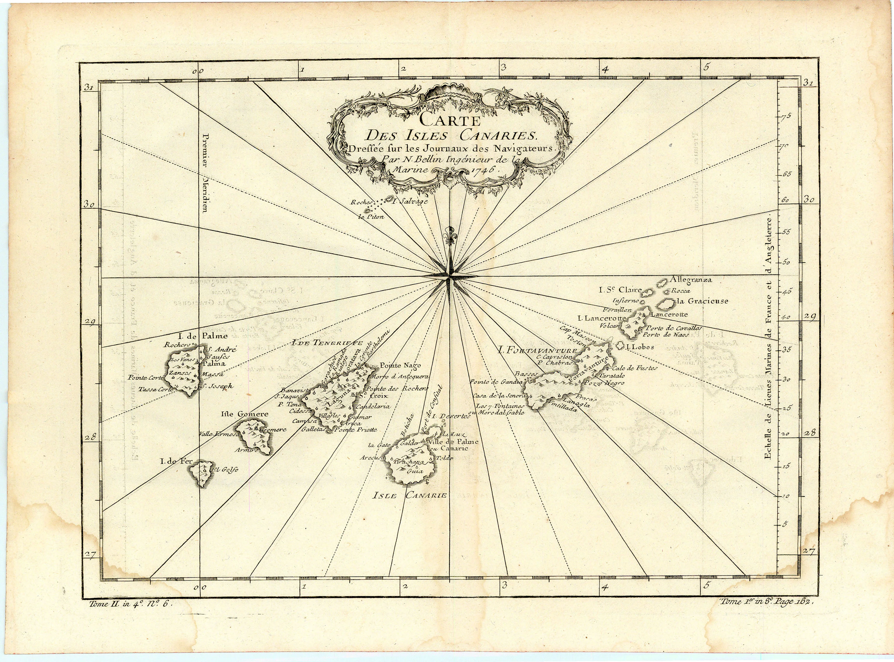
Carte des Isles Canaries. Dressée sur les Journaux des Navigateurs. Par N. Bellin Ingénieur de la Marine 1746.
"Map of the Canary Islands. Drawn upon the Journals of Navigators. By Nicolas Bellin Naval Engineer 1746."
Map of the Canary Islands off the northwest coast of Africa by French hydrographer and geographer Jacques-Nicolas Bellin (1703-1772), who produced a prodigious body of work over a nearly fifty-year career. Islands include la Isle de Palme (La Palma), Isle de Fer (El Hierro), Isle Gomere (La Gomera), Isle de Tenerife, Isle Canarie (Gran Canaria), Isle Fortavanture (Fuerteventura), and Isle Lancerotte (Lanzarote), among others. La 'Premier Meridien' runs through the Isle de Fer. This, termed the 'Ferro Meridian,' was used by Europeans for centuries as the Prime Meridian due to its traditional status as the supposed westernmost point of the Old World. Bellin's depiction of the islands places La Palma westward of El Hierro, which is inaccurate.
Appointed hydrographer of the French Navy at the age of eighteen, Bellin eventually became Hydrographer to the King in 1741. He published numerous sea atlases and charts which would be reprinted into the nineteenth century, as well as many maps depicting French colonial territories in the New World. His craftsmanship and commitment to accuracy earned him a distinguished reputation as one of the world's leading cartographers, and many other European mapmakers turned to him for source material.
- Title: Carte des Isles Canaries
-
Author: Jacques-Nicolas Bellin
- Date: 1746
- Medium: Copperplate engraving
- Condition: Very Good - light age toning, tide marks in lower corners, issued center fold
- Inches: 13 1/8 x 9 5/8 [Paper]
- Centimeters: 33.34 x 24.45 [Paper]
- Product ID: 102156
Carte des Isles Canaries. Dressée sur les Journaux des Navigateurs. Par N. Bellin Ingénieur de la Marine 1746.
"Map of the Canary Islands. Drawn upon the Journals of Navigators. By Nicolas Bellin Naval Engineer 1746."
Map of the Canary Islands off the northwest coast of Africa by French hydrographer and geographer Jacques-Nicolas Bellin (1703-1772), who produced a prodigious body of work over a nearly fifty-year career. Islands include la Isle de Palme (La Palma), Isle de Fer (El Hierro), Isle Gomere (La Gomera), Isle de Tenerife, Isle Canarie (Gran Canaria), Isle Fortavanture (Fuerteventura), and Isle Lancerotte (Lanzarote), among others. La 'Premier Meridien' runs through the Isle de Fer. This, termed the 'Ferro Meridian,' was used by Europeans for centuries as the Prime Meridian due to its traditional status as the supposed westernmost point of the Old World. Bellin's depiction of the islands places La Palma westward of El Hierro, which is inaccurate.
Appointed hydrographer of the French Navy at the age of eighteen, Bellin eventually became Hydrographer to the King in 1741. He published numerous sea atlases and charts which would be reprinted into the nineteenth century, as well as many maps depicting French colonial territories in the New World. His craftsmanship and commitment to accuracy earned him a distinguished reputation as one of the world's leading cartographers, and many other European mapmakers turned to him for source material.
Original: $125.00
-65%$125.00
$43.75Description
- Title: Carte des Isles Canaries
-
Author: Jacques-Nicolas Bellin
- Date: 1746
- Medium: Copperplate engraving
- Condition: Very Good - light age toning, tide marks in lower corners, issued center fold
- Inches: 13 1/8 x 9 5/8 [Paper]
- Centimeters: 33.34 x 24.45 [Paper]
- Product ID: 102156
Carte des Isles Canaries. Dressée sur les Journaux des Navigateurs. Par N. Bellin Ingénieur de la Marine 1746.
"Map of the Canary Islands. Drawn upon the Journals of Navigators. By Nicolas Bellin Naval Engineer 1746."
Map of the Canary Islands off the northwest coast of Africa by French hydrographer and geographer Jacques-Nicolas Bellin (1703-1772), who produced a prodigious body of work over a nearly fifty-year career. Islands include la Isle de Palme (La Palma), Isle de Fer (El Hierro), Isle Gomere (La Gomera), Isle de Tenerife, Isle Canarie (Gran Canaria), Isle Fortavanture (Fuerteventura), and Isle Lancerotte (Lanzarote), among others. La 'Premier Meridien' runs through the Isle de Fer. This, termed the 'Ferro Meridian,' was used by Europeans for centuries as the Prime Meridian due to its traditional status as the supposed westernmost point of the Old World. Bellin's depiction of the islands places La Palma westward of El Hierro, which is inaccurate.
Appointed hydrographer of the French Navy at the age of eighteen, Bellin eventually became Hydrographer to the King in 1741. He published numerous sea atlases and charts which would be reprinted into the nineteenth century, as well as many maps depicting French colonial territories in the New World. His craftsmanship and commitment to accuracy earned him a distinguished reputation as one of the world's leading cartographers, and many other European mapmakers turned to him for source material.