Chart of the Arabian Gulf: Bruce 1791
- Title: Chart of the Arabian Gulf
- Author: James Bruce
- Date: 1791
- Medium: Copperplate engraving
- Condition: Fair - age toning, wear, discoloring, paper loss, and separations at issued folds, foxing
- Inches: 19 1/2 x 26 3/4 [Paper]
- Centimeters: 49.53 x 67.95 [Paper]
- Product ID: 100592
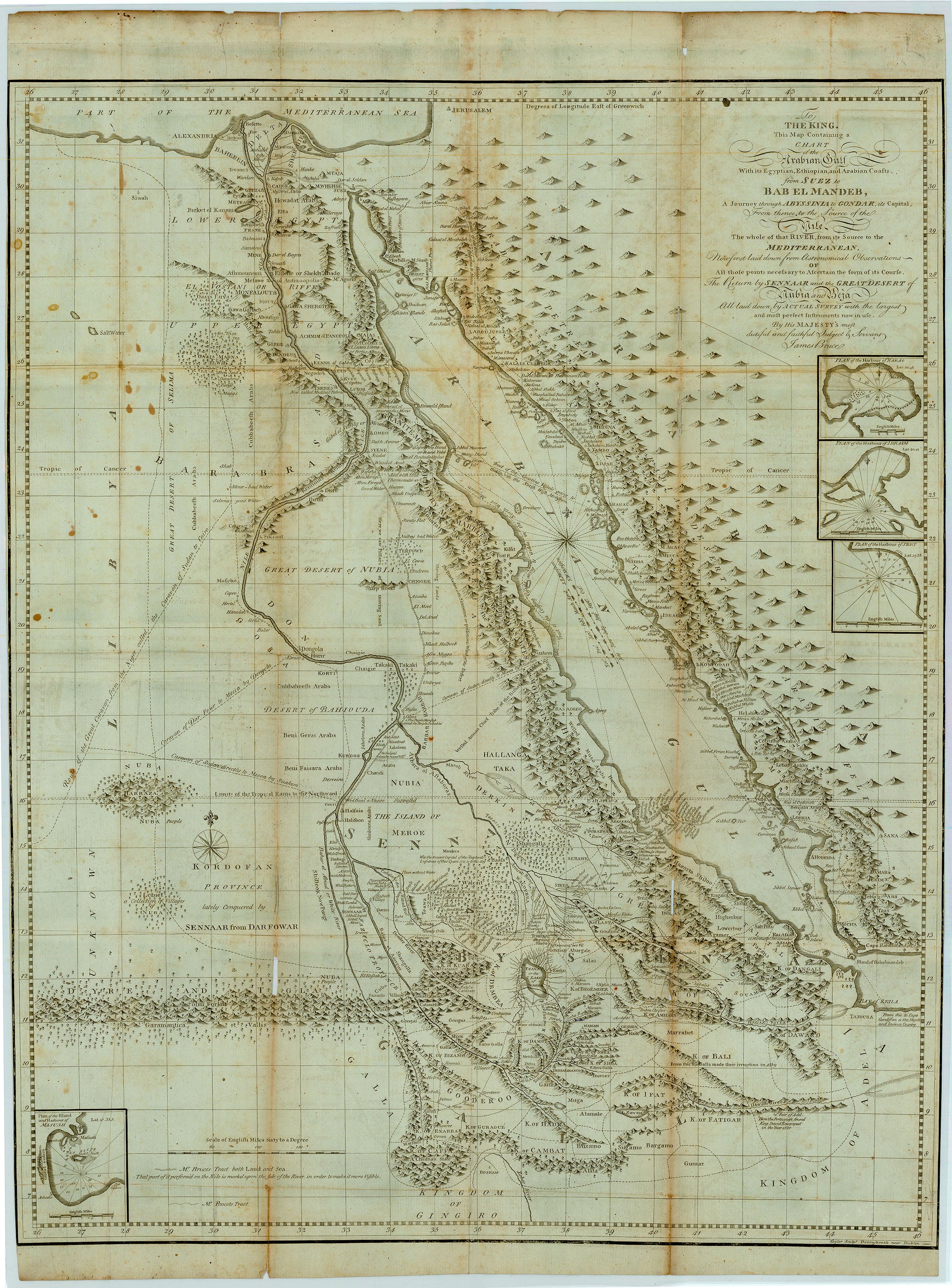
To the King. This Map Containing a Chart of the Arabian Gulf With its Egyptian, Ethiopian, and Arabian Coasts from Suez to Bab el Mandeb, A Journey through Abyssinia to Gondar, its Capital. From thence, to the Source of the Nile. The whole of that River, from its Source to the Mediterranean. Now first laid down from Astronomical Observations of All those points necessary to Ascertain the form of its Course. The Return by Sennaar and the Great Desert of Nubia and Beja All laid down by Actual Survey with the largest and most perfect Instruments now in use. By His Majesty's most dutiful and faithful Subject & Servant James Bruce.
Map of the Red Sea and the Nile River, showing the Blue Nile running from Lake Tana in present-day Ethiopia and joining with the White Nile in present-day Sudan. Surveyed by James Bruce, a Scottish explorer who led an expedition to find the source of the Nile. Includes inset plans of various harbors through which Bruce traveled, and marks the path of his party's travels. Map includes parts of present-day Egypt, Sudan, South Sudan, Eritrea, Saudi Arabia, Ethiopia, and Djibouti.
- Title: Chart of the Arabian Gulf
- Author: James Bruce
- Date: 1791
- Medium: Copperplate engraving
- Condition: Fair - age toning, wear, discoloring, paper loss, and separations at issued folds, foxing
- Inches: 19 1/2 x 26 3/4 [Paper]
- Centimeters: 49.53 x 67.95 [Paper]
- Product ID: 100592
To the King. This Map Containing a Chart of the Arabian Gulf With its Egyptian, Ethiopian, and Arabian Coasts from Suez to Bab el Mandeb, A Journey through Abyssinia to Gondar, its Capital. From thence, to the Source of the Nile. The whole of that River, from its Source to the Mediterranean. Now first laid down from Astronomical Observations of All those points necessary to Ascertain the form of its Course. The Return by Sennaar and the Great Desert of Nubia and Beja All laid down by Actual Survey with the largest and most perfect Instruments now in use. By His Majesty's most dutiful and faithful Subject & Servant James Bruce.
Map of the Red Sea and the Nile River, showing the Blue Nile running from Lake Tana in present-day Ethiopia and joining with the White Nile in present-day Sudan. Surveyed by James Bruce, a Scottish explorer who led an expedition to find the source of the Nile. Includes inset plans of various harbors through which Bruce traveled, and marks the path of his party's travels. Map includes parts of present-day Egypt, Sudan, South Sudan, Eritrea, Saudi Arabia, Ethiopia, and Djibouti.
Original: $650.00
-65%$650.00
$227.50Description
- Title: Chart of the Arabian Gulf
- Author: James Bruce
- Date: 1791
- Medium: Copperplate engraving
- Condition: Fair - age toning, wear, discoloring, paper loss, and separations at issued folds, foxing
- Inches: 19 1/2 x 26 3/4 [Paper]
- Centimeters: 49.53 x 67.95 [Paper]
- Product ID: 100592
To the King. This Map Containing a Chart of the Arabian Gulf With its Egyptian, Ethiopian, and Arabian Coasts from Suez to Bab el Mandeb, A Journey through Abyssinia to Gondar, its Capital. From thence, to the Source of the Nile. The whole of that River, from its Source to the Mediterranean. Now first laid down from Astronomical Observations of All those points necessary to Ascertain the form of its Course. The Return by Sennaar and the Great Desert of Nubia and Beja All laid down by Actual Survey with the largest and most perfect Instruments now in use. By His Majesty's most dutiful and faithful Subject & Servant James Bruce.
Map of the Red Sea and the Nile River, showing the Blue Nile running from Lake Tana in present-day Ethiopia and joining with the White Nile in present-day Sudan. Surveyed by James Bruce, a Scottish explorer who led an expedition to find the source of the Nile. Includes inset plans of various harbors through which Bruce traveled, and marks the path of his party's travels. Map includes parts of present-day Egypt, Sudan, South Sudan, Eritrea, Saudi Arabia, Ethiopia, and Djibouti.