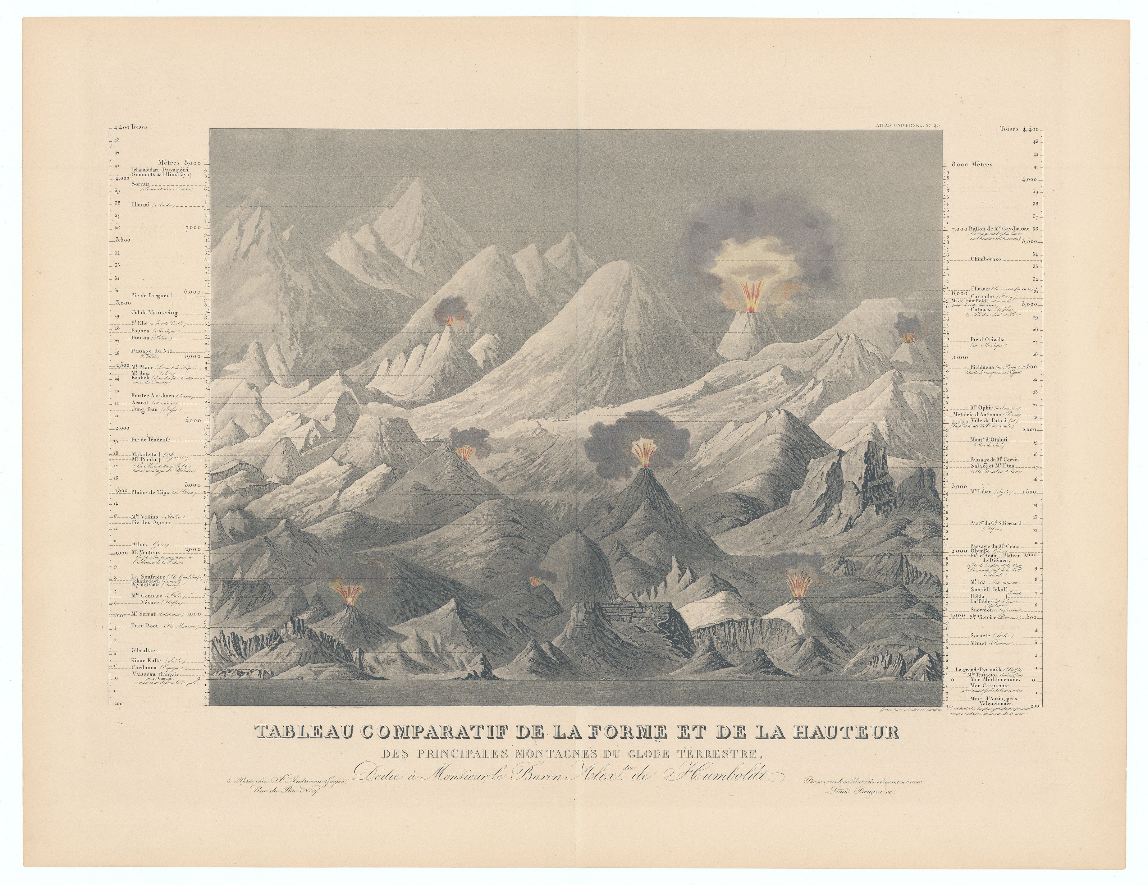
Comparative Table of the Shape and Height of the Principal Mountains of the Earth...: Andriveau-Goujon, 1840
- Title: Tableau Comparatif De La Forme Et De La Hauteur Des Principales Montagnes Du Globe Terrestre...
-
Author: J. Andriveau-Goujon
- Date: 1840
- Condition: Excellent - Even, overall age toning with a clean, sharply defined centerfold
- Inches: 22 1/4 x 15 7/8 [Image]
- Centimeters: 56.51 x 40.32 [Image]
- Product ID: 308622
This comparative chart presents a visually arresting synthesis of the world’s most prominent mountains, meticulously arrayed to contrast both their shapes and relative altitudes. Published in the early 19th century, the print employs a dramatic panoramic composition to bring together well-known peaks from across the globe, each meticulously labeled and scaled with reference to contemporary measurements.
Flanking the central illustration are precise columns listing the elevation of each summit in meters, with a clear delineation between Old and New World ranges. Volcanoes are rendered erupting, underscoring the fascination with geophysical phenomena characteristic of the period’s scientific inquiry. Dedicated to Baron Alexander von Humboldt, a pioneering figure in physical geography and earth sciences, the chart exemplifies the 19th-century drive to classify, compare, and visually encapsulate natural wonders within the expanding boundaries of global knowledge.
Background on Creator
J. Andriveau-Goujon (1832-1897) was a prominent Parisian mapmaker and publisher active throughout the 19th century, known for producing numerous maps and atlases that often-featured collaboration with leading French cartographers such as Brue and Levasseur. The publishing house, originally formed when Eugène Andriveau married the daughter of Jean Goujon, became renowned for its high-quality publications under the Andriveau-Goujon name, which was used by multiple generations of the family. The firm's offerings were highly regarded until its stock was acquired by M. Barrère in 1892.
- Title: Tableau Comparatif De La Forme Et De La Hauteur Des Principales Montagnes Du Globe Terrestre...
-
Author: J. Andriveau-Goujon
- Date: 1840
- Condition: Excellent - Even, overall age toning with a clean, sharply defined centerfold
- Inches: 22 1/4 x 15 7/8 [Image]
- Centimeters: 56.51 x 40.32 [Image]
- Product ID: 308622
This comparative chart presents a visually arresting synthesis of the world’s most prominent mountains, meticulously arrayed to contrast both their shapes and relative altitudes. Published in the early 19th century, the print employs a dramatic panoramic composition to bring together well-known peaks from across the globe, each meticulously labeled and scaled with reference to contemporary measurements.
Flanking the central illustration are precise columns listing the elevation of each summit in meters, with a clear delineation between Old and New World ranges. Volcanoes are rendered erupting, underscoring the fascination with geophysical phenomena characteristic of the period’s scientific inquiry. Dedicated to Baron Alexander von Humboldt, a pioneering figure in physical geography and earth sciences, the chart exemplifies the 19th-century drive to classify, compare, and visually encapsulate natural wonders within the expanding boundaries of global knowledge.
Background on Creator
J. Andriveau-Goujon (1832-1897) was a prominent Parisian mapmaker and publisher active throughout the 19th century, known for producing numerous maps and atlases that often-featured collaboration with leading French cartographers such as Brue and Levasseur. The publishing house, originally formed when Eugène Andriveau married the daughter of Jean Goujon, became renowned for its high-quality publications under the Andriveau-Goujon name, which was used by multiple generations of the family. The firm's offerings were highly regarded until its stock was acquired by M. Barrère in 1892.
Description
- Title: Tableau Comparatif De La Forme Et De La Hauteur Des Principales Montagnes Du Globe Terrestre...
-
Author: J. Andriveau-Goujon
- Date: 1840
- Condition: Excellent - Even, overall age toning with a clean, sharply defined centerfold
- Inches: 22 1/4 x 15 7/8 [Image]
- Centimeters: 56.51 x 40.32 [Image]
- Product ID: 308622
This comparative chart presents a visually arresting synthesis of the world’s most prominent mountains, meticulously arrayed to contrast both their shapes and relative altitudes. Published in the early 19th century, the print employs a dramatic panoramic composition to bring together well-known peaks from across the globe, each meticulously labeled and scaled with reference to contemporary measurements.
Flanking the central illustration are precise columns listing the elevation of each summit in meters, with a clear delineation between Old and New World ranges. Volcanoes are rendered erupting, underscoring the fascination with geophysical phenomena characteristic of the period’s scientific inquiry. Dedicated to Baron Alexander von Humboldt, a pioneering figure in physical geography and earth sciences, the chart exemplifies the 19th-century drive to classify, compare, and visually encapsulate natural wonders within the expanding boundaries of global knowledge.
Background on Creator
J. Andriveau-Goujon (1832-1897) was a prominent Parisian mapmaker and publisher active throughout the 19th century, known for producing numerous maps and atlases that often-featured collaboration with leading French cartographers such as Brue and Levasseur. The publishing house, originally formed when Eugène Andriveau married the daughter of Jean Goujon, became renowned for its high-quality publications under the Andriveau-Goujon name, which was used by multiple generations of the family. The firm's offerings were highly regarded until its stock was acquired by M. Barrère in 1892.