Grundriss des Hafens von Acapulco: Bellin 1754
- Title: Grundriss des Hafens von Acapulco
- Author: Jacques-Nicolas Bellin
- Date: 1754
- Medium: Copperplate engraving
- Condition: Very Good Plus - age toning, light foxing and surface dirt
- Inches: 7 1/2 x 9 1/2 [Paper]
- Centimeters: 19.05 x 24.13 [Paper]
- Product ID: 313005
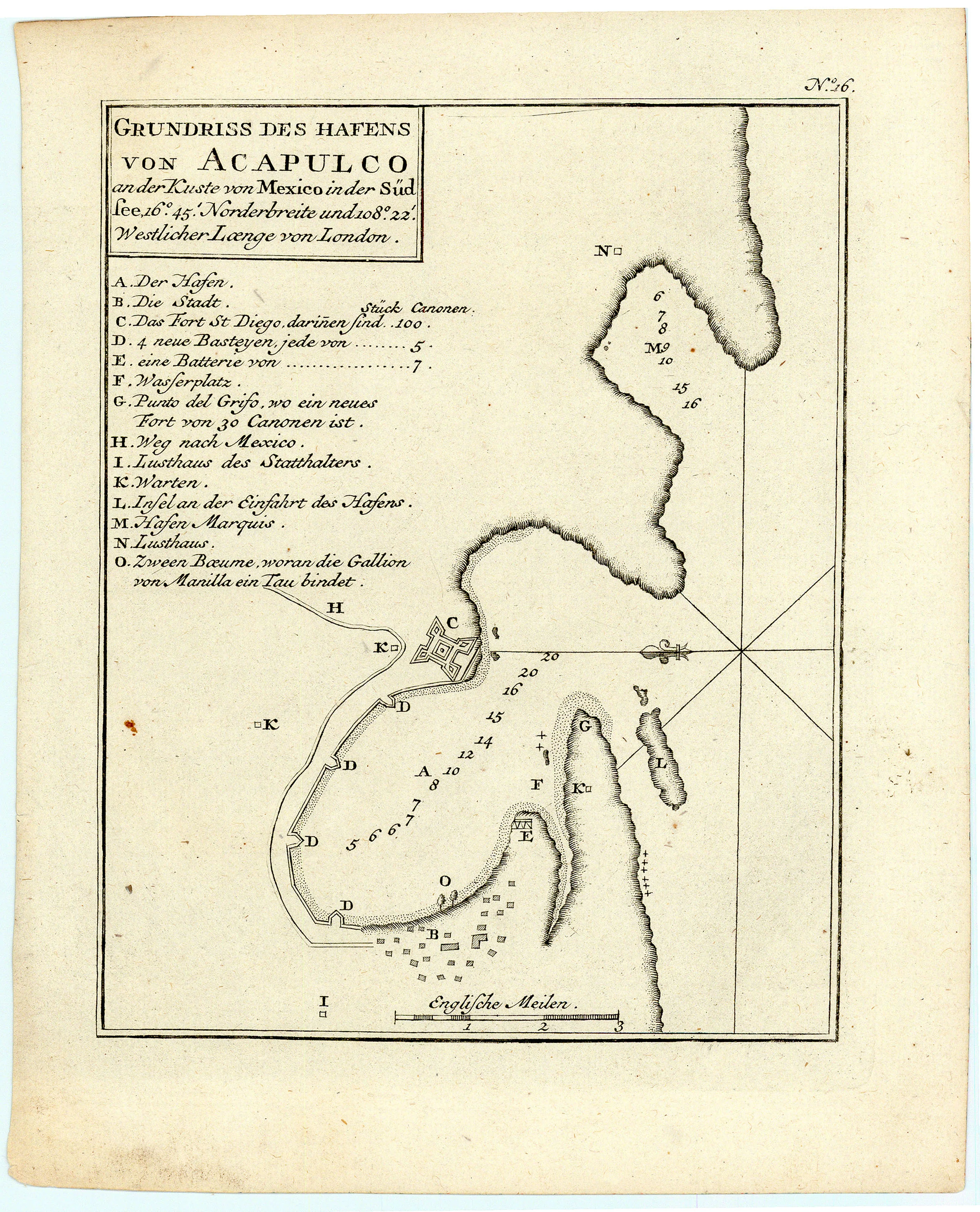
Grundriss des Hafens von Acapulco an der Kuste von Mexico in der Süd see, 16.° 45.' Norderbreite und 108.° 22.' Westlicher Laenge von London.
"Plan of the port of Acapulco on the coast of Mexico in the South Seas, latitude 16. ° 45. ' North and longitude 108.° 22.' West of London."
Map of the city of Acapulco along the southwest coast of Mexico. Includes a legend which denotes major sites and buildings.
About the Cartographer:
Jacques-Nicolas Bellin (1703-1772) was a French hydrographer and geographer who produced a prodigious body of work over a nearly fifty-year career. Appointed hydrographer of the French Navy at the age of eighteen, he eventually became Hydrographer to the King in 1741. Bellin published numerous sea atlases and charts which would be reprinted into the nineteenth century, as well as many maps depicting French colonial territories in the New World. His craftsmanship and commitment to accuracy earned him a distinguished reputation as one of the world's leading cartographers, and many other European mapmakers turned to him for source material.
- Title: Grundriss des Hafens von Acapulco
- Author: Jacques-Nicolas Bellin
- Date: 1754
- Medium: Copperplate engraving
- Condition: Very Good Plus - age toning, light foxing and surface dirt
- Inches: 7 1/2 x 9 1/2 [Paper]
- Centimeters: 19.05 x 24.13 [Paper]
- Product ID: 313005
Grundriss des Hafens von Acapulco an der Kuste von Mexico in der Süd see, 16.° 45.' Norderbreite und 108.° 22.' Westlicher Laenge von London.
"Plan of the port of Acapulco on the coast of Mexico in the South Seas, latitude 16. ° 45. ' North and longitude 108.° 22.' West of London."
Map of the city of Acapulco along the southwest coast of Mexico. Includes a legend which denotes major sites and buildings.
About the Cartographer:
Jacques-Nicolas Bellin (1703-1772) was a French hydrographer and geographer who produced a prodigious body of work over a nearly fifty-year career. Appointed hydrographer of the French Navy at the age of eighteen, he eventually became Hydrographer to the King in 1741. Bellin published numerous sea atlases and charts which would be reprinted into the nineteenth century, as well as many maps depicting French colonial territories in the New World. His craftsmanship and commitment to accuracy earned him a distinguished reputation as one of the world's leading cartographers, and many other European mapmakers turned to him for source material.
Original: $95.00
-65%$95.00
$33.25Description
- Title: Grundriss des Hafens von Acapulco
- Author: Jacques-Nicolas Bellin
- Date: 1754
- Medium: Copperplate engraving
- Condition: Very Good Plus - age toning, light foxing and surface dirt
- Inches: 7 1/2 x 9 1/2 [Paper]
- Centimeters: 19.05 x 24.13 [Paper]
- Product ID: 313005
Grundriss des Hafens von Acapulco an der Kuste von Mexico in der Süd see, 16.° 45.' Norderbreite und 108.° 22.' Westlicher Laenge von London.
"Plan of the port of Acapulco on the coast of Mexico in the South Seas, latitude 16. ° 45. ' North and longitude 108.° 22.' West of London."
Map of the city of Acapulco along the southwest coast of Mexico. Includes a legend which denotes major sites and buildings.
About the Cartographer:
Jacques-Nicolas Bellin (1703-1772) was a French hydrographer and geographer who produced a prodigious body of work over a nearly fifty-year career. Appointed hydrographer of the French Navy at the age of eighteen, he eventually became Hydrographer to the King in 1741. Bellin published numerous sea atlases and charts which would be reprinted into the nineteenth century, as well as many maps depicting French colonial territories in the New World. His craftsmanship and commitment to accuracy earned him a distinguished reputation as one of the world's leading cartographers, and many other European mapmakers turned to him for source material.