Harris County: General Land Office, 1940
- Title: HARRIS COUNTY
- Author: General Land Office
- Date: 1940
- Condition: See description
- Inches: 45 1/2 x 36 3/8 [Paper]
- Centimeters: 115.57 x 92.39 [Paper]
- Product ID: 308587
"One-of-a-Kind Cartographic Gem: The Hidden Map of Harris County"
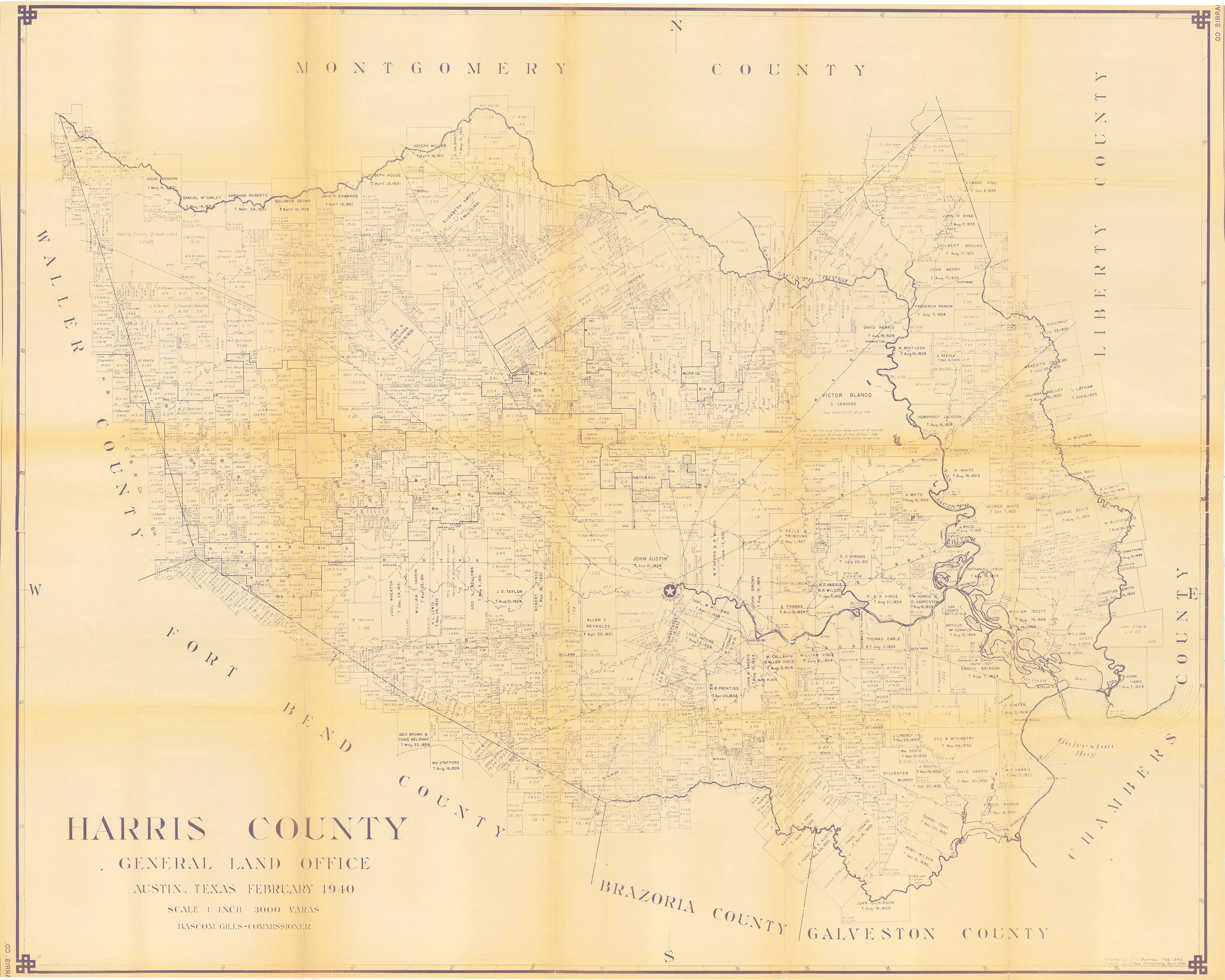
This exceedingly rare large-scale land survey of Harris County, Texas, was issued by the General Land Office in Austin and dated February 1940. It provides a comprehensive depiction of county boundaries, property divisions, and land ownership as they appeared at the time, featuring the placements of major rivers, bayous, and township subdivisions throughout Harris County. Every surrounding county—Montgomery, Liberty, Chambers, Galveston, Brazoria, Fort Bend, and Waller—is clearly labeled, highlighting Harris County’s extensive geographic connections in the region.
Notably, this example is a photocopy most likely produced using a spirit duplicator, commonly known as a "Ditto machine." This is evident in the characteristic bluish-purple hue of the printed lines and text, as well as subtle signs of ink diffusion and mild unevenness in tones across the map. Spirit duplication was a common method for reproducing documents in the mid-20th century, prized for its efficiency in producing crisp, readable copies—though the process also resulted in a distinctive appearance that collectors and archivists can readily identify today. The present photocopy offers a glimpse into both the region's land history and mid-century document reproduction practices.
Harris County in the 1940s
In the 1940s, Harris County, Texas, was rapidly transforming as Houston and the surrounding region experienced significant growth, driven by industrial expansion and the ongoing impact of World War II. The county’s population surged due to the boom in defense industries, oil refineries, and manufacturing plants, which attracted workers from across the nation. Houston, the county seat, nearly tripled in size during this decade, with new neighborhoods and suburbs developing to accommodate this influx.
Major public projects, such as highways and port improvements, contributed to Harris County’s growing importance as a hub for transportation and commerce. The Houston Ship Channel, which fostered much of the industrial expansion, brought new opportunities and made the area vital to the national war effort. Agriculture, including rice and vegetables, continued to be prominent outside the city, although industry was steadily overtaking traditional rural livelihoods.
Condition
Printed on yellow stock utilizing aniline purple dye via spirit duplication. The map exhibits subtle evidence of dye migration and mild tonal variance intrinsic to the duplicator process. Issued with original folds visible and minimal paper loss at some folds; overall condition remains excellent with no further detracting flaws.
Rarity
Exceptionally scarce in institutional collections, this map is reportedly held by only four institutions according to OCLC records. No examples are documented in private collections or public auction sales.
Background on Creator
The Texas General Land Office was founded in 1836 and is Texas’s oldest state agency. Its main function is to manage state-owned lands and mineral rights, overseeing leases and sales, and generating revenue for the Permanent School Fund, which supports public education. The agency also preserves Texas land grant records, manages disaster recovery programs, safeguards coastline and natural resources, operates The Alamo, and provides services to veterans.
- Title: HARRIS COUNTY
- Author: General Land Office
- Date: 1940
- Condition: See description
- Inches: 45 1/2 x 36 3/8 [Paper]
- Centimeters: 115.57 x 92.39 [Paper]
- Product ID: 308587
"One-of-a-Kind Cartographic Gem: The Hidden Map of Harris County"
This exceedingly rare large-scale land survey of Harris County, Texas, was issued by the General Land Office in Austin and dated February 1940. It provides a comprehensive depiction of county boundaries, property divisions, and land ownership as they appeared at the time, featuring the placements of major rivers, bayous, and township subdivisions throughout Harris County. Every surrounding county—Montgomery, Liberty, Chambers, Galveston, Brazoria, Fort Bend, and Waller—is clearly labeled, highlighting Harris County’s extensive geographic connections in the region.
Notably, this example is a photocopy most likely produced using a spirit duplicator, commonly known as a "Ditto machine." This is evident in the characteristic bluish-purple hue of the printed lines and text, as well as subtle signs of ink diffusion and mild unevenness in tones across the map. Spirit duplication was a common method for reproducing documents in the mid-20th century, prized for its efficiency in producing crisp, readable copies—though the process also resulted in a distinctive appearance that collectors and archivists can readily identify today. The present photocopy offers a glimpse into both the region's land history and mid-century document reproduction practices.
Harris County in the 1940s
In the 1940s, Harris County, Texas, was rapidly transforming as Houston and the surrounding region experienced significant growth, driven by industrial expansion and the ongoing impact of World War II. The county’s population surged due to the boom in defense industries, oil refineries, and manufacturing plants, which attracted workers from across the nation. Houston, the county seat, nearly tripled in size during this decade, with new neighborhoods and suburbs developing to accommodate this influx.
Major public projects, such as highways and port improvements, contributed to Harris County’s growing importance as a hub for transportation and commerce. The Houston Ship Channel, which fostered much of the industrial expansion, brought new opportunities and made the area vital to the national war effort. Agriculture, including rice and vegetables, continued to be prominent outside the city, although industry was steadily overtaking traditional rural livelihoods.
Condition
Printed on yellow stock utilizing aniline purple dye via spirit duplication. The map exhibits subtle evidence of dye migration and mild tonal variance intrinsic to the duplicator process. Issued with original folds visible and minimal paper loss at some folds; overall condition remains excellent with no further detracting flaws.
Rarity
Exceptionally scarce in institutional collections, this map is reportedly held by only four institutions according to OCLC records. No examples are documented in private collections or public auction sales.
Background on Creator
The Texas General Land Office was founded in 1836 and is Texas’s oldest state agency. Its main function is to manage state-owned lands and mineral rights, overseeing leases and sales, and generating revenue for the Permanent School Fund, which supports public education. The agency also preserves Texas land grant records, manages disaster recovery programs, safeguards coastline and natural resources, operates The Alamo, and provides services to veterans.
Description
- Title: HARRIS COUNTY
- Author: General Land Office
- Date: 1940
- Condition: See description
- Inches: 45 1/2 x 36 3/8 [Paper]
- Centimeters: 115.57 x 92.39 [Paper]
- Product ID: 308587
"One-of-a-Kind Cartographic Gem: The Hidden Map of Harris County"
This exceedingly rare large-scale land survey of Harris County, Texas, was issued by the General Land Office in Austin and dated February 1940. It provides a comprehensive depiction of county boundaries, property divisions, and land ownership as they appeared at the time, featuring the placements of major rivers, bayous, and township subdivisions throughout Harris County. Every surrounding county—Montgomery, Liberty, Chambers, Galveston, Brazoria, Fort Bend, and Waller—is clearly labeled, highlighting Harris County’s extensive geographic connections in the region.
Notably, this example is a photocopy most likely produced using a spirit duplicator, commonly known as a "Ditto machine." This is evident in the characteristic bluish-purple hue of the printed lines and text, as well as subtle signs of ink diffusion and mild unevenness in tones across the map. Spirit duplication was a common method for reproducing documents in the mid-20th century, prized for its efficiency in producing crisp, readable copies—though the process also resulted in a distinctive appearance that collectors and archivists can readily identify today. The present photocopy offers a glimpse into both the region's land history and mid-century document reproduction practices.
Harris County in the 1940s
In the 1940s, Harris County, Texas, was rapidly transforming as Houston and the surrounding region experienced significant growth, driven by industrial expansion and the ongoing impact of World War II. The county’s population surged due to the boom in defense industries, oil refineries, and manufacturing plants, which attracted workers from across the nation. Houston, the county seat, nearly tripled in size during this decade, with new neighborhoods and suburbs developing to accommodate this influx.
Major public projects, such as highways and port improvements, contributed to Harris County’s growing importance as a hub for transportation and commerce. The Houston Ship Channel, which fostered much of the industrial expansion, brought new opportunities and made the area vital to the national war effort. Agriculture, including rice and vegetables, continued to be prominent outside the city, although industry was steadily overtaking traditional rural livelihoods.
Condition
Printed on yellow stock utilizing aniline purple dye via spirit duplication. The map exhibits subtle evidence of dye migration and mild tonal variance intrinsic to the duplicator process. Issued with original folds visible and minimal paper loss at some folds; overall condition remains excellent with no further detracting flaws.
Rarity
Exceptionally scarce in institutional collections, this map is reportedly held by only four institutions according to OCLC records. No examples are documented in private collections or public auction sales.
Background on Creator
The Texas General Land Office was founded in 1836 and is Texas’s oldest state agency. Its main function is to manage state-owned lands and mineral rights, overseeing leases and sales, and generating revenue for the Permanent School Fund, which supports public education. The agency also preserves Texas land grant records, manages disaster recovery programs, safeguards coastline and natural resources, operates The Alamo, and provides services to veterans.