Hildago County: Texas General Land Office, c.1927
- Title: Hildago County
- Author: Texas General Land Office
- Date: c.1927
- Condition: Light age toning, else perfect, with two original binding holes at top.
- Inches: 14 x 17 [Paper]
- Centimeters: 35.56 x 43.18 [Paper]
- Product ID: 308698
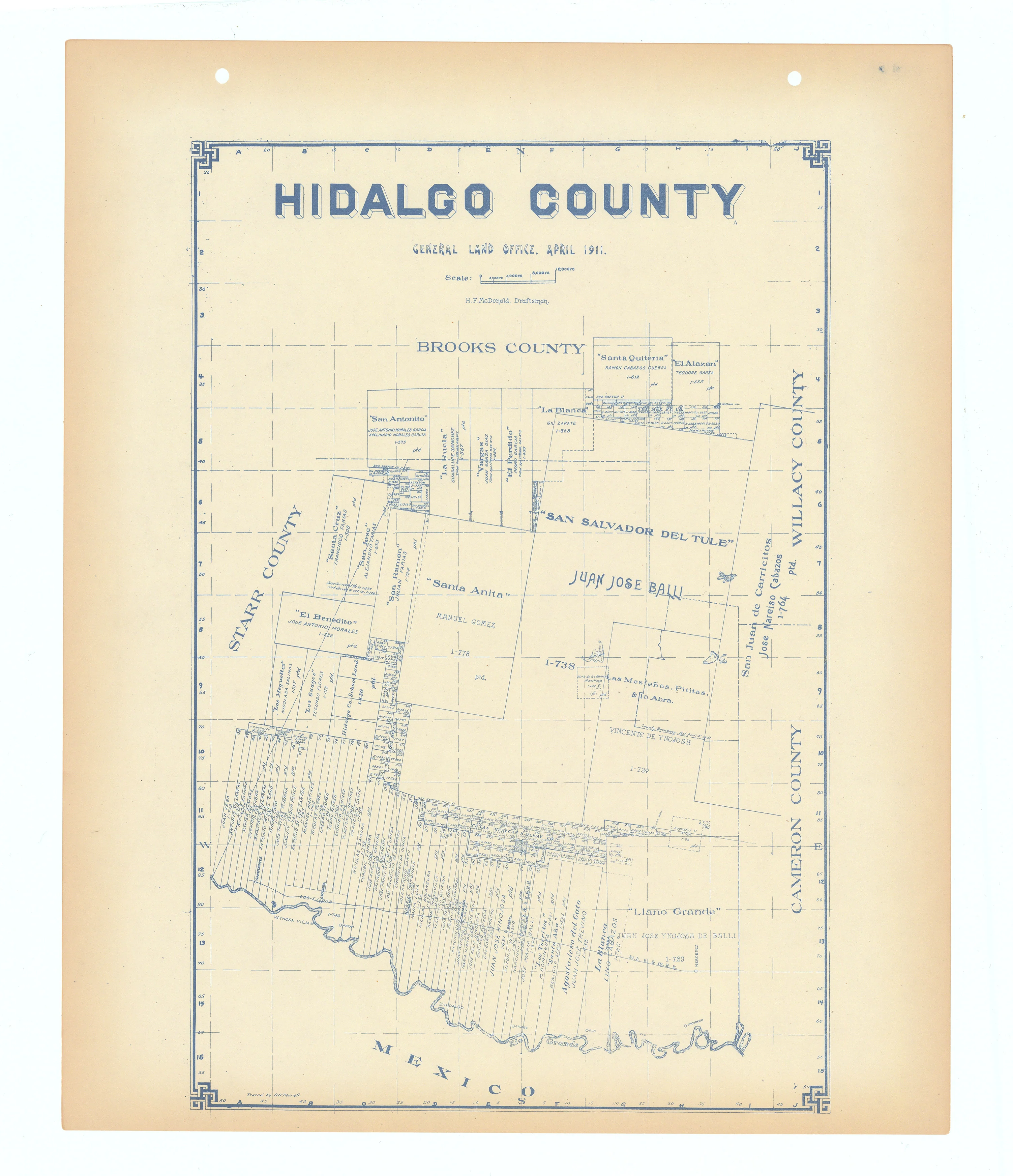
Original antique Hildago County map published in the atlas Maps of All Texas Counties by Wolf & Bennett in Tulsa, Oklahoma. Highly detailed Texas General Land Office map showing land patents, block and tract numbers, landowners, towns, railroads, and portions of adjacent counties where property boundaries extend beyond county limits.
There is some debate regarding the date of this atlas. We rely on The Portal to Texas History which dates the atlas to c. 1927. Maps from the collections held at the University of Texas at Arlington are provided to The Portal to Texas History, a digital repository hosted by the UNT Libraries.
Survey date – 1911
Background on Creator
The Texas General Land Office was founded in 1836 and is Texas’s oldest state agency. Its main function is to manage state-owned lands and mineral rights, overseeing leases and sales, and generating revenue for the Permanent School Fund, which supports public education. The agency also preserves Texas land grant records, manages disaster recovery programs, safeguards coastline and natural resources, operates The Alamo, and provides services to veterans.
- Title: Hildago County
- Author: Texas General Land Office
- Date: c.1927
- Condition: Light age toning, else perfect, with two original binding holes at top.
- Inches: 14 x 17 [Paper]
- Centimeters: 35.56 x 43.18 [Paper]
- Product ID: 308698
Original antique Hildago County map published in the atlas Maps of All Texas Counties by Wolf & Bennett in Tulsa, Oklahoma. Highly detailed Texas General Land Office map showing land patents, block and tract numbers, landowners, towns, railroads, and portions of adjacent counties where property boundaries extend beyond county limits.
There is some debate regarding the date of this atlas. We rely on The Portal to Texas History which dates the atlas to c. 1927. Maps from the collections held at the University of Texas at Arlington are provided to The Portal to Texas History, a digital repository hosted by the UNT Libraries.
Survey date – 1911
Background on Creator
The Texas General Land Office was founded in 1836 and is Texas’s oldest state agency. Its main function is to manage state-owned lands and mineral rights, overseeing leases and sales, and generating revenue for the Permanent School Fund, which supports public education. The agency also preserves Texas land grant records, manages disaster recovery programs, safeguards coastline and natural resources, operates The Alamo, and provides services to veterans.
Description
- Title: Hildago County
- Author: Texas General Land Office
- Date: c.1927
- Condition: Light age toning, else perfect, with two original binding holes at top.
- Inches: 14 x 17 [Paper]
- Centimeters: 35.56 x 43.18 [Paper]
- Product ID: 308698
Original antique Hildago County map published in the atlas Maps of All Texas Counties by Wolf & Bennett in Tulsa, Oklahoma. Highly detailed Texas General Land Office map showing land patents, block and tract numbers, landowners, towns, railroads, and portions of adjacent counties where property boundaries extend beyond county limits.
There is some debate regarding the date of this atlas. We rely on The Portal to Texas History which dates the atlas to c. 1927. Maps from the collections held at the University of Texas at Arlington are provided to The Portal to Texas History, a digital repository hosted by the UNT Libraries.
Survey date – 1911
Background on Creator
The Texas General Land Office was founded in 1836 and is Texas’s oldest state agency. Its main function is to manage state-owned lands and mineral rights, overseeing leases and sales, and generating revenue for the Permanent School Fund, which supports public education. The agency also preserves Texas land grant records, manages disaster recovery programs, safeguards coastline and natural resources, operates The Alamo, and provides services to veterans.