Houston Ship Channel Atkinson Island to Alexander Island: U. S. Coast and Geodetic Survey 1951
- Title: Houston Ship Channel Atkinson Island to Alexander Island
- Author: U. S. Coast and Geodetic Survey
- Date: 1951
- Medium: Chromolithograph
- Condition: Excellent - light age toning, horizontal and vertical fold lines
- Inches: 43 1/8 x 32 1/4 [Paper]
- Centimeters: 109.54 x 81.92 [Paper]
- Product ID: 318054
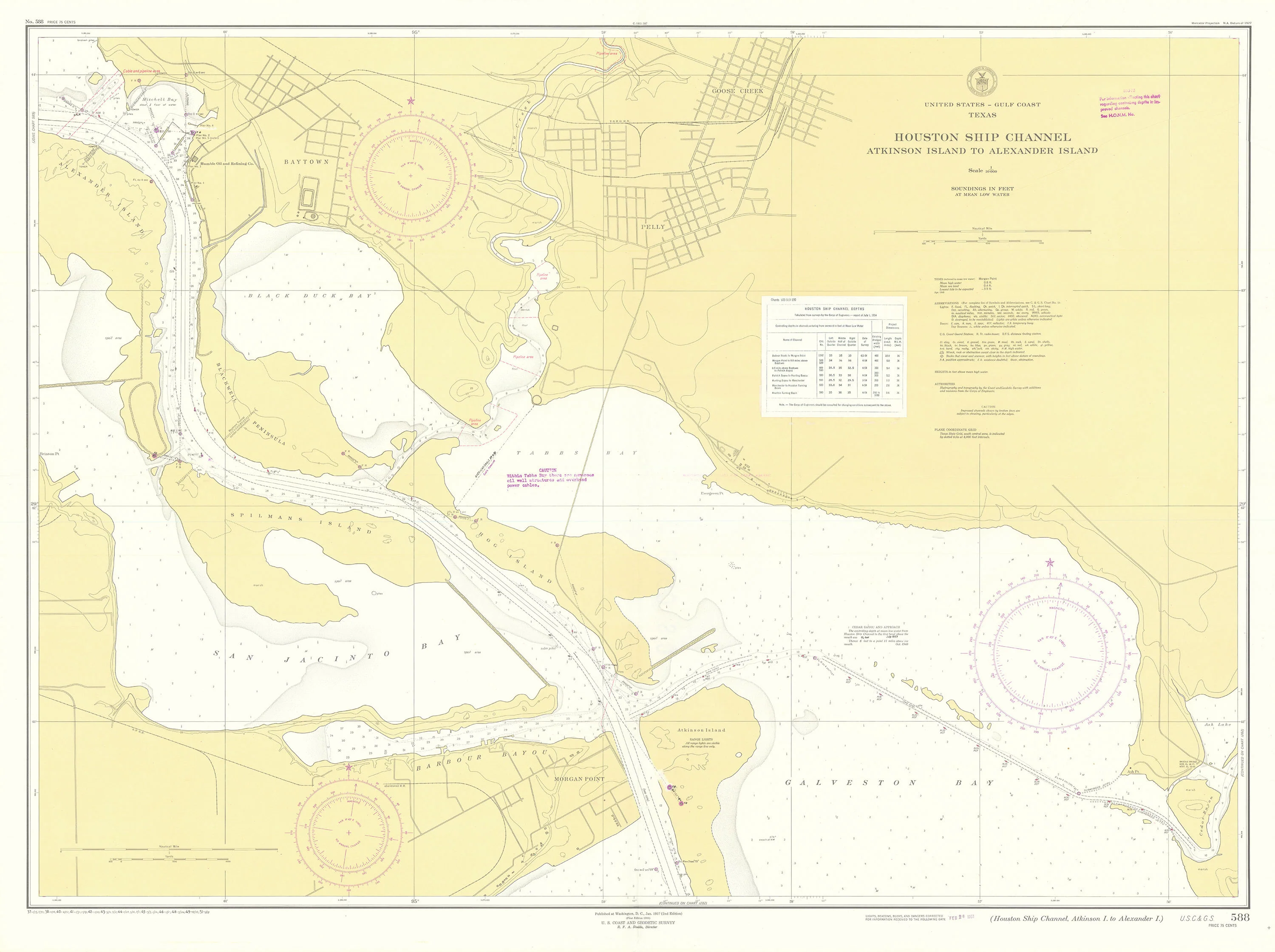
Map of the Houston Ship Channel stretching from the mouth of Galveston Bay to the city of Baytown, Texas. Map shows the railroad network of the region and lists information related to oil pipelines and wells, underwater cables, water depths, magnetic variation, tides and currents, and climate and terrain. Addition posted on map dating to 1954 indicates channel depth at different points.
The United States Coast and Geodetic Survey was the first scientific agency of the United States Government, established on February 10, 1807, initially to map and chart the country's coastline. Originally known as the Survey of the Coast, it evolved over time to become a comprehensive scientific organization responsible for numerous critical tasks, including mapping, geodesy, oceanography, and producing nautical and aeronautical charts.
Throughout its history from 1807 to 1970, the agency played a pivotal role in scientific exploration, supporting military operations, and developing critical navigation technologies, ultimately becoming a cornerstone of modern American scientific advancement. In 1970, the agency was incorporated into the newly formed National Oceanic and Atmospheric Administration (NOAA), continuing its legacy of scientific innovation and exploration.
- Title: Houston Ship Channel Atkinson Island to Alexander Island
- Author: U. S. Coast and Geodetic Survey
- Date: 1951
- Medium: Chromolithograph
- Condition: Excellent - light age toning, horizontal and vertical fold lines
- Inches: 43 1/8 x 32 1/4 [Paper]
- Centimeters: 109.54 x 81.92 [Paper]
- Product ID: 318054
Map of the Houston Ship Channel stretching from the mouth of Galveston Bay to the city of Baytown, Texas. Map shows the railroad network of the region and lists information related to oil pipelines and wells, underwater cables, water depths, magnetic variation, tides and currents, and climate and terrain. Addition posted on map dating to 1954 indicates channel depth at different points.
The United States Coast and Geodetic Survey was the first scientific agency of the United States Government, established on February 10, 1807, initially to map and chart the country's coastline. Originally known as the Survey of the Coast, it evolved over time to become a comprehensive scientific organization responsible for numerous critical tasks, including mapping, geodesy, oceanography, and producing nautical and aeronautical charts.
Throughout its history from 1807 to 1970, the agency played a pivotal role in scientific exploration, supporting military operations, and developing critical navigation technologies, ultimately becoming a cornerstone of modern American scientific advancement. In 1970, the agency was incorporated into the newly formed National Oceanic and Atmospheric Administration (NOAA), continuing its legacy of scientific innovation and exploration.
Description
- Title: Houston Ship Channel Atkinson Island to Alexander Island
- Author: U. S. Coast and Geodetic Survey
- Date: 1951
- Medium: Chromolithograph
- Condition: Excellent - light age toning, horizontal and vertical fold lines
- Inches: 43 1/8 x 32 1/4 [Paper]
- Centimeters: 109.54 x 81.92 [Paper]
- Product ID: 318054
Map of the Houston Ship Channel stretching from the mouth of Galveston Bay to the city of Baytown, Texas. Map shows the railroad network of the region and lists information related to oil pipelines and wells, underwater cables, water depths, magnetic variation, tides and currents, and climate and terrain. Addition posted on map dating to 1954 indicates channel depth at different points.
The United States Coast and Geodetic Survey was the first scientific agency of the United States Government, established on February 10, 1807, initially to map and chart the country's coastline. Originally known as the Survey of the Coast, it evolved over time to become a comprehensive scientific organization responsible for numerous critical tasks, including mapping, geodesy, oceanography, and producing nautical and aeronautical charts.
Throughout its history from 1807 to 1970, the agency played a pivotal role in scientific exploration, supporting military operations, and developing critical navigation technologies, ultimately becoming a cornerstone of modern American scientific advancement. In 1970, the agency was incorporated into the newly formed National Oceanic and Atmospheric Administration (NOAA), continuing its legacy of scientific innovation and exploration.











