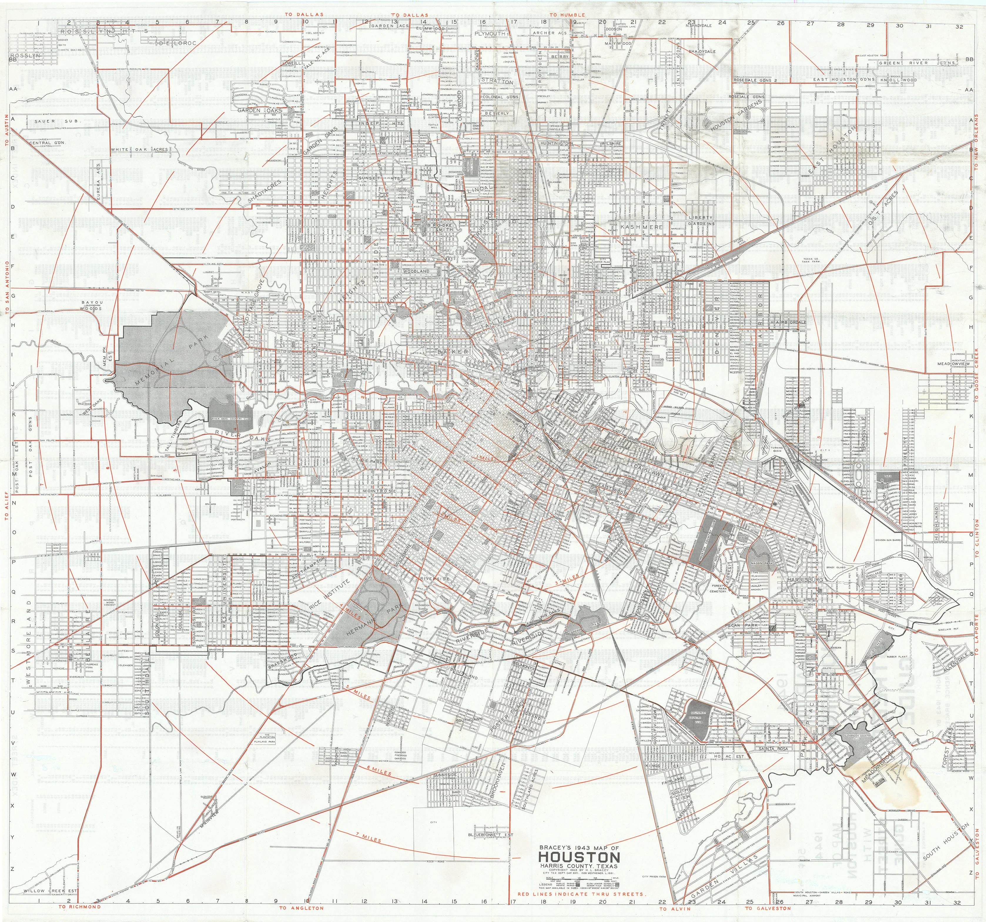
Bracey's 1943 Map of Houston: Bracey, 1943
- Title: Bracey's 1943 Map of Houston | Harris County, Texas
- Author: H.L. Bracey
- Date: 1943
- Condition: Clean example with scattered tears, now experly mended, with only minor areas of paper loss in a few places; otherwise in good condition.
- Inches: 28 3/8 x 26 3/8 [Paper]
- Centimeters: 72.07 x 66.99 [Paper]
- Product ID: 308677
This finely detailed Bracey’s Map of Houston with Street Guide presents the rapidly expanding city in 1943 as a dense matrix of named streets, subdivisions, and additions radiating from the downtown core, with block numbers and lot lines meticulously engraved in black and key thoroughfares, section lines, and radial highways boldly overprinted in red, all set within a neat line bearing directional notations to Dallas, Galveston, Beaumont, and other regional destinations.
Houston in the 1940s
In the 1940s Houston was a booming wartime and postwar city, its economy was fueled by oil, petrochemicals, shipbuilding, and other defense-related industries that drew tens of thousands of new residents. The population swelled from roughly 384,000 in 1940 toward 600,000 by decade’s end, and the city began a transformative period of annexation that dramatically expanded its municipal boundaries. During these years planners laid out a modern thoroughfare and future freeway system, the Port of Houston climbed to national prominence, and major institutions such as the Texas Medical Center solidified Houston’s emerging role as a regional metropolis.
Rarity
Laurence Bracey’s street and block maps are relatively rare today because they were conceived as working tools rather than keepsakes, heavily used by real‑estate professionals, surveyors, and city officials and often discarded once superseded by newer editions. Surviving examples are further thinned by their large format and frequent wall or desk use, which led to tearing, staining, and loss, so complete, well‑preserved sheets—especially early or wartime printings and maps for smaller markets outside Houston—tend to appear only infrequently on the market and are keenly sought by collectors of Texas urban cartography.
Background on Creator
Hugh Laurence Bracey (H. L. or H. Laurence Bracey) was a 20th‑century Texas mapmaker and publisher best known for his detailed block maps of Houston and other cities, which he began issuing in the early 1920s. Born in 1893, Bracey produced large-format atlases and wall maps that showed individual blocks, lot dimensions, additions, subdivisions, and the names of property owners, making them indispensable working tools for real‑estate professionals, surveyors, and city officials in the mid‑20th century. His imprint appears on successive editions of “Bracey’s Block Maps of the City of Houston” and similar compilations for Austin, and his work captures the rapid urban growth and subdivision pattern of Texas cities during the interwar and postwar building booms.
- Title: Bracey's 1943 Map of Houston | Harris County, Texas
- Author: H.L. Bracey
- Date: 1943
- Condition: Clean example with scattered tears, now experly mended, with only minor areas of paper loss in a few places; otherwise in good condition.
- Inches: 28 3/8 x 26 3/8 [Paper]
- Centimeters: 72.07 x 66.99 [Paper]
- Product ID: 308677
This finely detailed Bracey’s Map of Houston with Street Guide presents the rapidly expanding city in 1943 as a dense matrix of named streets, subdivisions, and additions radiating from the downtown core, with block numbers and lot lines meticulously engraved in black and key thoroughfares, section lines, and radial highways boldly overprinted in red, all set within a neat line bearing directional notations to Dallas, Galveston, Beaumont, and other regional destinations.
Houston in the 1940s
In the 1940s Houston was a booming wartime and postwar city, its economy was fueled by oil, petrochemicals, shipbuilding, and other defense-related industries that drew tens of thousands of new residents. The population swelled from roughly 384,000 in 1940 toward 600,000 by decade’s end, and the city began a transformative period of annexation that dramatically expanded its municipal boundaries. During these years planners laid out a modern thoroughfare and future freeway system, the Port of Houston climbed to national prominence, and major institutions such as the Texas Medical Center solidified Houston’s emerging role as a regional metropolis.
Rarity
Laurence Bracey’s street and block maps are relatively rare today because they were conceived as working tools rather than keepsakes, heavily used by real‑estate professionals, surveyors, and city officials and often discarded once superseded by newer editions. Surviving examples are further thinned by their large format and frequent wall or desk use, which led to tearing, staining, and loss, so complete, well‑preserved sheets—especially early or wartime printings and maps for smaller markets outside Houston—tend to appear only infrequently on the market and are keenly sought by collectors of Texas urban cartography.
Background on Creator
Hugh Laurence Bracey (H. L. or H. Laurence Bracey) was a 20th‑century Texas mapmaker and publisher best known for his detailed block maps of Houston and other cities, which he began issuing in the early 1920s. Born in 1893, Bracey produced large-format atlases and wall maps that showed individual blocks, lot dimensions, additions, subdivisions, and the names of property owners, making them indispensable working tools for real‑estate professionals, surveyors, and city officials in the mid‑20th century. His imprint appears on successive editions of “Bracey’s Block Maps of the City of Houston” and similar compilations for Austin, and his work captures the rapid urban growth and subdivision pattern of Texas cities during the interwar and postwar building booms.
Original: $1,195.00
-65%$1,195.00
$418.25Description
- Title: Bracey's 1943 Map of Houston | Harris County, Texas
- Author: H.L. Bracey
- Date: 1943
- Condition: Clean example with scattered tears, now experly mended, with only minor areas of paper loss in a few places; otherwise in good condition.
- Inches: 28 3/8 x 26 3/8 [Paper]
- Centimeters: 72.07 x 66.99 [Paper]
- Product ID: 308677
This finely detailed Bracey’s Map of Houston with Street Guide presents the rapidly expanding city in 1943 as a dense matrix of named streets, subdivisions, and additions radiating from the downtown core, with block numbers and lot lines meticulously engraved in black and key thoroughfares, section lines, and radial highways boldly overprinted in red, all set within a neat line bearing directional notations to Dallas, Galveston, Beaumont, and other regional destinations.
Houston in the 1940s
In the 1940s Houston was a booming wartime and postwar city, its economy was fueled by oil, petrochemicals, shipbuilding, and other defense-related industries that drew tens of thousands of new residents. The population swelled from roughly 384,000 in 1940 toward 600,000 by decade’s end, and the city began a transformative period of annexation that dramatically expanded its municipal boundaries. During these years planners laid out a modern thoroughfare and future freeway system, the Port of Houston climbed to national prominence, and major institutions such as the Texas Medical Center solidified Houston’s emerging role as a regional metropolis.
Rarity
Laurence Bracey’s street and block maps are relatively rare today because they were conceived as working tools rather than keepsakes, heavily used by real‑estate professionals, surveyors, and city officials and often discarded once superseded by newer editions. Surviving examples are further thinned by their large format and frequent wall or desk use, which led to tearing, staining, and loss, so complete, well‑preserved sheets—especially early or wartime printings and maps for smaller markets outside Houston—tend to appear only infrequently on the market and are keenly sought by collectors of Texas urban cartography.
Background on Creator
Hugh Laurence Bracey (H. L. or H. Laurence Bracey) was a 20th‑century Texas mapmaker and publisher best known for his detailed block maps of Houston and other cities, which he began issuing in the early 1920s. Born in 1893, Bracey produced large-format atlases and wall maps that showed individual blocks, lot dimensions, additions, subdivisions, and the names of property owners, making them indispensable working tools for real‑estate professionals, surveyors, and city officials in the mid‑20th century. His imprint appears on successive editions of “Bracey’s Block Maps of the City of Houston” and similar compilations for Austin, and his work captures the rapid urban growth and subdivision pattern of Texas cities during the interwar and postwar building booms.











