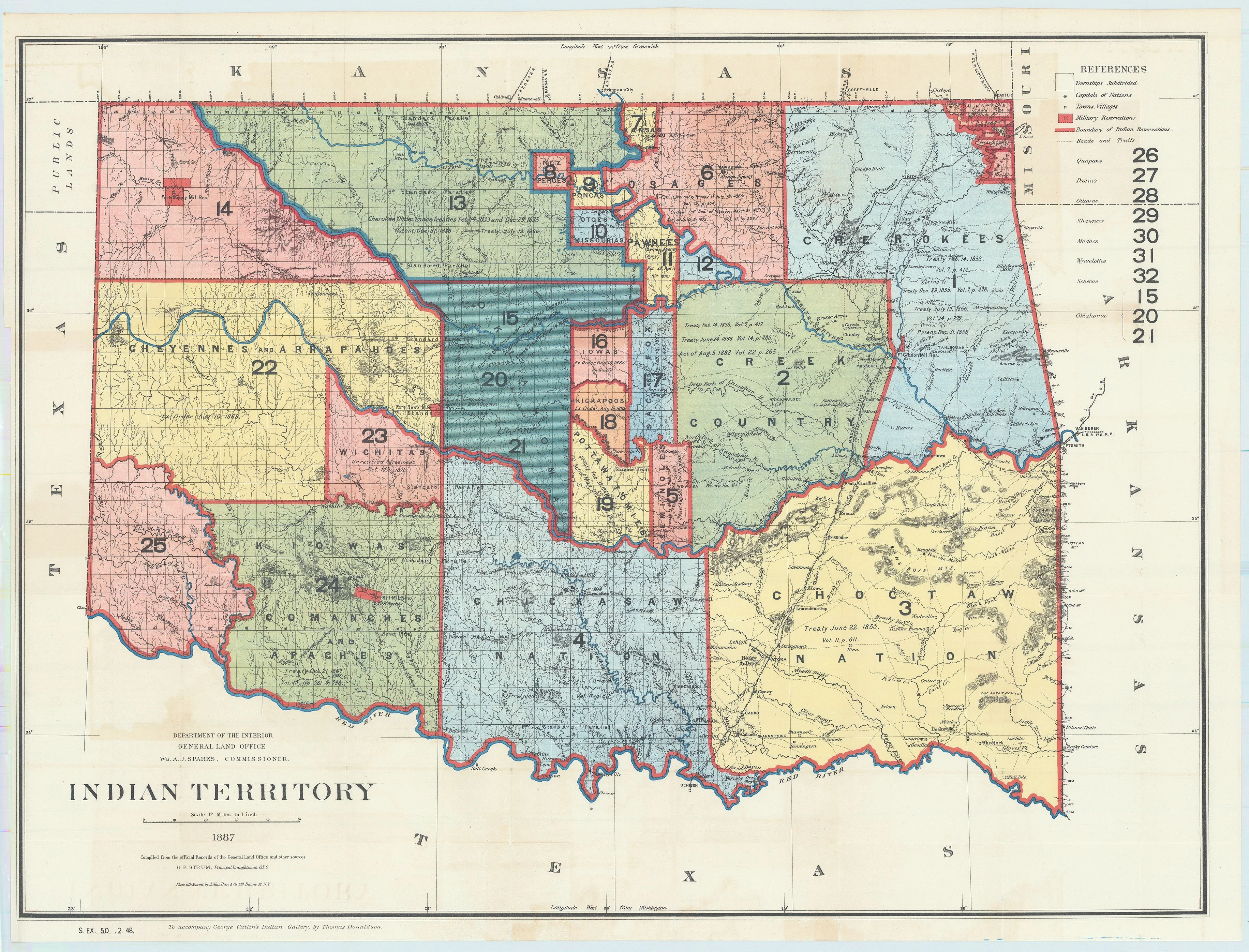
Indian Territory: General Land Office, 1887
- Title: Indian Territory
- Author: Department of the Interior | General Land Office
- Date: 1887
- Condition: Excellent - issued folds with minimal wear and age-related toning throughout.
- Inches: 32 3/8 x 24 1/8 [Image]
- Centimeters: 82.23 x 61.27 [Image]
- Product ID: 308654
This interesting map is from the series of General Land Office maps reflecting the status of lands allocated to various tribes as shown through color-coding. The Indian Territory was initially established as a place to relocate the principal eastern Indian tribes and the Five Civilized Tribes formed the nucleus of an organized government. By 1887 however, representatives of some fifty tribes had settled on lands once promised to the original five. This map reflects many of these allocations and shows 25 separate regions and names seven more. A small portion of the panhandle is shown and labeled Public Lands. Drawn by G. P. Strum and published to accompany George Catlin's Indian Gallery, by Thomas Donaldson.
Background on Creator
The U.S. Department of the Interior is a federal executive department created in 1849 to manage most federally owned lands, natural resources, and related programs, including national parks, wildlife refuges, mineral resources, and many responsibilities involving Native American and Alaska Native communities. It is headed by the secretary of the interior, sits in the president’s Cabinet, and has often been described as a broad domestic agency overseeing conservation, land management, and cultural and historic preservation across the country.
The United States General Land Office was established in 1812 as a separate federal agency to administer the public domain, handling the surveying, platting, and sale or disposal of public lands—especially in the expanding western territories—under laws like the Land Ordinance of 1785 and later the Homestead Act. In 1849 it was placed under the Department of the Interior, and in 1946 it was merged with the U.S. Grazing Service to form the Bureau of Land Management, shifting its role from primarily selling public lands to managing them for uses such as grazing, mineral leasing, and broader resource stewardship.
- Title: Indian Territory
- Author: Department of the Interior | General Land Office
- Date: 1887
- Condition: Excellent - issued folds with minimal wear and age-related toning throughout.
- Inches: 32 3/8 x 24 1/8 [Image]
- Centimeters: 82.23 x 61.27 [Image]
- Product ID: 308654
This interesting map is from the series of General Land Office maps reflecting the status of lands allocated to various tribes as shown through color-coding. The Indian Territory was initially established as a place to relocate the principal eastern Indian tribes and the Five Civilized Tribes formed the nucleus of an organized government. By 1887 however, representatives of some fifty tribes had settled on lands once promised to the original five. This map reflects many of these allocations and shows 25 separate regions and names seven more. A small portion of the panhandle is shown and labeled Public Lands. Drawn by G. P. Strum and published to accompany George Catlin's Indian Gallery, by Thomas Donaldson.
Background on Creator
The U.S. Department of the Interior is a federal executive department created in 1849 to manage most federally owned lands, natural resources, and related programs, including national parks, wildlife refuges, mineral resources, and many responsibilities involving Native American and Alaska Native communities. It is headed by the secretary of the interior, sits in the president’s Cabinet, and has often been described as a broad domestic agency overseeing conservation, land management, and cultural and historic preservation across the country.
The United States General Land Office was established in 1812 as a separate federal agency to administer the public domain, handling the surveying, platting, and sale or disposal of public lands—especially in the expanding western territories—under laws like the Land Ordinance of 1785 and later the Homestead Act. In 1849 it was placed under the Department of the Interior, and in 1946 it was merged with the U.S. Grazing Service to form the Bureau of Land Management, shifting its role from primarily selling public lands to managing them for uses such as grazing, mineral leasing, and broader resource stewardship.
Description
- Title: Indian Territory
- Author: Department of the Interior | General Land Office
- Date: 1887
- Condition: Excellent - issued folds with minimal wear and age-related toning throughout.
- Inches: 32 3/8 x 24 1/8 [Image]
- Centimeters: 82.23 x 61.27 [Image]
- Product ID: 308654
This interesting map is from the series of General Land Office maps reflecting the status of lands allocated to various tribes as shown through color-coding. The Indian Territory was initially established as a place to relocate the principal eastern Indian tribes and the Five Civilized Tribes formed the nucleus of an organized government. By 1887 however, representatives of some fifty tribes had settled on lands once promised to the original five. This map reflects many of these allocations and shows 25 separate regions and names seven more. A small portion of the panhandle is shown and labeled Public Lands. Drawn by G. P. Strum and published to accompany George Catlin's Indian Gallery, by Thomas Donaldson.
Background on Creator
The U.S. Department of the Interior is a federal executive department created in 1849 to manage most federally owned lands, natural resources, and related programs, including national parks, wildlife refuges, mineral resources, and many responsibilities involving Native American and Alaska Native communities. It is headed by the secretary of the interior, sits in the president’s Cabinet, and has often been described as a broad domestic agency overseeing conservation, land management, and cultural and historic preservation across the country.
The United States General Land Office was established in 1812 as a separate federal agency to administer the public domain, handling the surveying, platting, and sale or disposal of public lands—especially in the expanding western territories—under laws like the Land Ordinance of 1785 and later the Homestead Act. In 1849 it was placed under the Department of the Interior, and in 1946 it was merged with the U.S. Grazing Service to form the Bureau of Land Management, shifting its role from primarily selling public lands to managing them for uses such as grazing, mineral leasing, and broader resource stewardship.