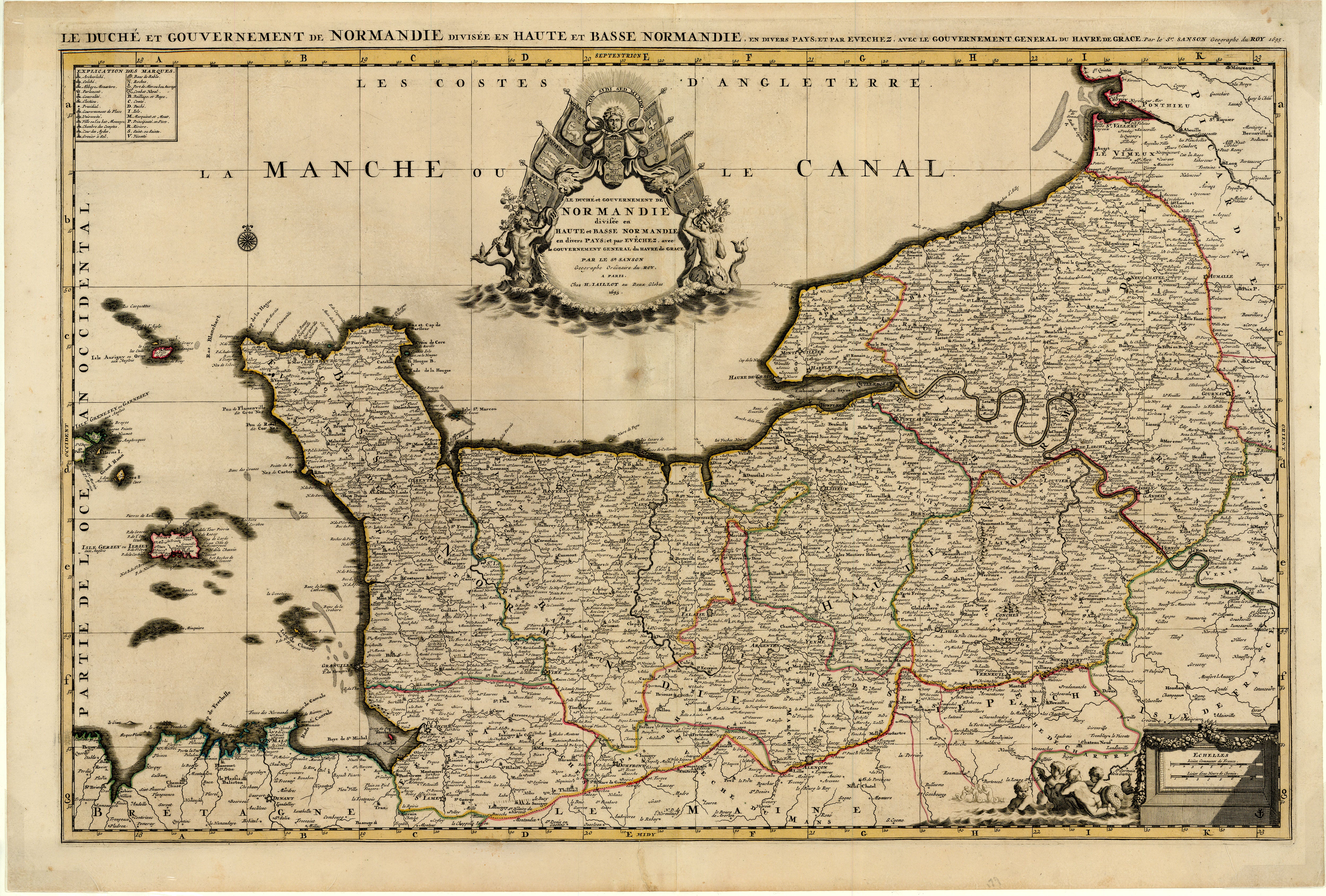
Le Duché et Gouvernement de Normandie: Sanson 1695
- Title: Le Duché et Gouvernement de Normandie
- Author: Guillaume Sanson
- Date: 1695
- Medium: Hand-colored copperplate engraving
- Condition: Very Good Plus - age toning, repaired tears bottom margin, light scuffing/ surface dirt, issued center fold, light foxing
- Inches: 37 3/8 x 25 [Paper]
- Centimeters: 94.93 x 63.5 [Paper]
- Product ID: 224033
Le Duché et Gouvernement de Normandie divisée en Haute et Basse Normandie en divers Pays; et par Evêchez, avec le Gouvernement General, du Havre, de Grace. Par le Sr. Sanson Geographe Ordinaire du Roy. A Paris. Chez H. Iallot au Deux Globes 1695.
"The Duchy and Government of Normandy divided into Upper and Lower Normandy in various Countries; and by bishop, with the General Government, of Havre-de-Grâce [city and port]. By Sr. Sanson Geographer Ordinaire of the King. In Paris. House of H. Jaillot at Deux Globes 1695."
Map of Normandy, France along the English Channel by Guillaume Sanson (1633-1703), son of French cartographer Nicolas Sanson (1600-1667). Following the death of his father, Guillaume took over the family firm with the help of his brother Hugh Jaillot. Map includes the Channel Islands of Jersey, Guernsey, and Orny, as well as parts of Brittany, Maine, and Picardy. Sanson labels major cities and towns such as Rouen, Bayeux, and Dieppe, as well as topographical features. Legend in top left corner explains the significance of symbols used on the map to indicate county seats, universities, monasteries, archbishoprics, and other notable locations.
- Title: Le Duché et Gouvernement de Normandie
- Author: Guillaume Sanson
- Date: 1695
- Medium: Hand-colored copperplate engraving
- Condition: Very Good Plus - age toning, repaired tears bottom margin, light scuffing/ surface dirt, issued center fold, light foxing
- Inches: 37 3/8 x 25 [Paper]
- Centimeters: 94.93 x 63.5 [Paper]
- Product ID: 224033
Le Duché et Gouvernement de Normandie divisée en Haute et Basse Normandie en divers Pays; et par Evêchez, avec le Gouvernement General, du Havre, de Grace. Par le Sr. Sanson Geographe Ordinaire du Roy. A Paris. Chez H. Iallot au Deux Globes 1695.
"The Duchy and Government of Normandy divided into Upper and Lower Normandy in various Countries; and by bishop, with the General Government, of Havre-de-Grâce [city and port]. By Sr. Sanson Geographer Ordinaire of the King. In Paris. House of H. Jaillot at Deux Globes 1695."
Map of Normandy, France along the English Channel by Guillaume Sanson (1633-1703), son of French cartographer Nicolas Sanson (1600-1667). Following the death of his father, Guillaume took over the family firm with the help of his brother Hugh Jaillot. Map includes the Channel Islands of Jersey, Guernsey, and Orny, as well as parts of Brittany, Maine, and Picardy. Sanson labels major cities and towns such as Rouen, Bayeux, and Dieppe, as well as topographical features. Legend in top left corner explains the significance of symbols used on the map to indicate county seats, universities, monasteries, archbishoprics, and other notable locations.
Original: $1,695.00
-65%$1,695.00
$593.25Description
- Title: Le Duché et Gouvernement de Normandie
- Author: Guillaume Sanson
- Date: 1695
- Medium: Hand-colored copperplate engraving
- Condition: Very Good Plus - age toning, repaired tears bottom margin, light scuffing/ surface dirt, issued center fold, light foxing
- Inches: 37 3/8 x 25 [Paper]
- Centimeters: 94.93 x 63.5 [Paper]
- Product ID: 224033
Le Duché et Gouvernement de Normandie divisée en Haute et Basse Normandie en divers Pays; et par Evêchez, avec le Gouvernement General, du Havre, de Grace. Par le Sr. Sanson Geographe Ordinaire du Roy. A Paris. Chez H. Iallot au Deux Globes 1695.
"The Duchy and Government of Normandy divided into Upper and Lower Normandy in various Countries; and by bishop, with the General Government, of Havre-de-Grâce [city and port]. By Sr. Sanson Geographer Ordinaire of the King. In Paris. House of H. Jaillot at Deux Globes 1695."
Map of Normandy, France along the English Channel by Guillaume Sanson (1633-1703), son of French cartographer Nicolas Sanson (1600-1667). Following the death of his father, Guillaume took over the family firm with the help of his brother Hugh Jaillot. Map includes the Channel Islands of Jersey, Guernsey, and Orny, as well as parts of Brittany, Maine, and Picardy. Sanson labels major cities and towns such as Rouen, Bayeux, and Dieppe, as well as topographical features. Legend in top left corner explains the significance of symbols used on the map to indicate county seats, universities, monasteries, archbishoprics, and other notable locations.