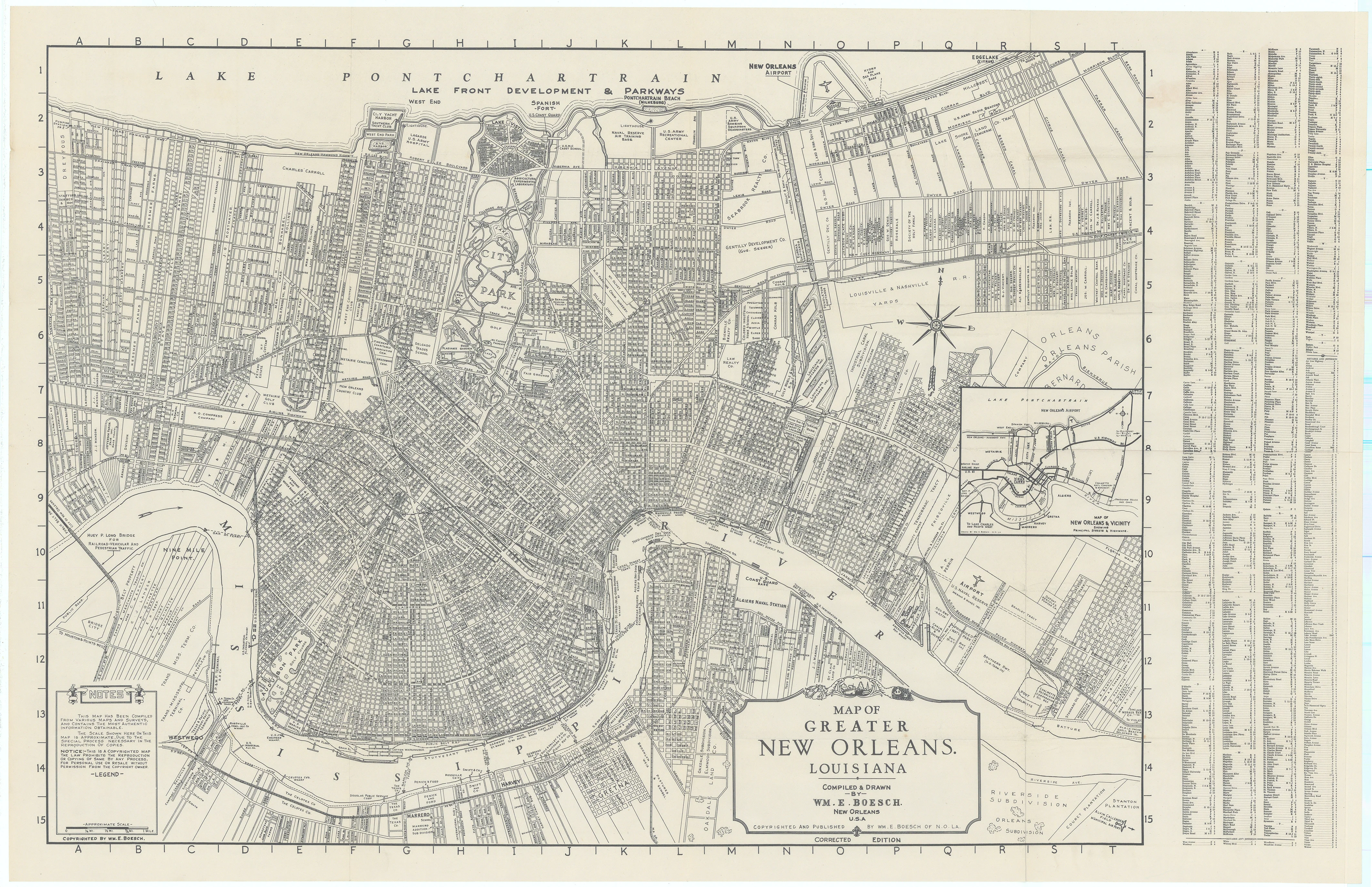
Map of Greater New Orleans. Louisiana: Boesch, 1934
- Title: MAP OF GREATER NEW ORLEANS. LOUISIANA
- Author: WM. E. Boesch
- Date: 1934
- Condition: Excellent
- Inches: 32 5/8 x 20 3/8 [Image]
- Centimeters: 82.86 x 51.75 [Image]
- Product ID: 308383
This remarkably detailed city plan of New Orleans, Louisiana, was produced and published locally by William E. Boesch in 1934. Its intricate labels offer a wealth of information about the Vieux Carré and the city at large during the Great Depression, highlighting transportation networks, major property owners, notable businesses, schools, recreational sites, military facilities, and more. The map also illustrates the concentration of industries along the Mississippi River, underscoring its central role in the city’s economic life.
Accompanying the map is a guidebook featuring a street index and curated lists of local attractions.
Background on Creator
William E. Boesch was an early 20th-century cartographer and publisher based in New Orleans. He is noted for producing detailed maps of the Greater New Orleans area. Boesch also authored a book titled "Commercial and Engineering Map Drawing and Lettering" in 1930, which contributed to the field of cartography by providing guidance on mapmaking techniques.
In addition to his mapping work, Boesch's intricate labels and cartographic details have been recognized for offering valuable historical insights into New Orleans neighborhoods, such as the Vieux Carré, during the early 20th century. He founded his mapmaking business in New Orleans in the 1920s and remained active in the field for several decades.
- Title: MAP OF GREATER NEW ORLEANS. LOUISIANA
- Author: WM. E. Boesch
- Date: 1934
- Condition: Excellent
- Inches: 32 5/8 x 20 3/8 [Image]
- Centimeters: 82.86 x 51.75 [Image]
- Product ID: 308383
This remarkably detailed city plan of New Orleans, Louisiana, was produced and published locally by William E. Boesch in 1934. Its intricate labels offer a wealth of information about the Vieux Carré and the city at large during the Great Depression, highlighting transportation networks, major property owners, notable businesses, schools, recreational sites, military facilities, and more. The map also illustrates the concentration of industries along the Mississippi River, underscoring its central role in the city’s economic life.
Accompanying the map is a guidebook featuring a street index and curated lists of local attractions.
Background on Creator
William E. Boesch was an early 20th-century cartographer and publisher based in New Orleans. He is noted for producing detailed maps of the Greater New Orleans area. Boesch also authored a book titled "Commercial and Engineering Map Drawing and Lettering" in 1930, which contributed to the field of cartography by providing guidance on mapmaking techniques.
In addition to his mapping work, Boesch's intricate labels and cartographic details have been recognized for offering valuable historical insights into New Orleans neighborhoods, such as the Vieux Carré, during the early 20th century. He founded his mapmaking business in New Orleans in the 1920s and remained active in the field for several decades.
Original: $245.00
-65%$245.00
$85.75Description
- Title: MAP OF GREATER NEW ORLEANS. LOUISIANA
- Author: WM. E. Boesch
- Date: 1934
- Condition: Excellent
- Inches: 32 5/8 x 20 3/8 [Image]
- Centimeters: 82.86 x 51.75 [Image]
- Product ID: 308383
This remarkably detailed city plan of New Orleans, Louisiana, was produced and published locally by William E. Boesch in 1934. Its intricate labels offer a wealth of information about the Vieux Carré and the city at large during the Great Depression, highlighting transportation networks, major property owners, notable businesses, schools, recreational sites, military facilities, and more. The map also illustrates the concentration of industries along the Mississippi River, underscoring its central role in the city’s economic life.
Accompanying the map is a guidebook featuring a street index and curated lists of local attractions.
Background on Creator
William E. Boesch was an early 20th-century cartographer and publisher based in New Orleans. He is noted for producing detailed maps of the Greater New Orleans area. Boesch also authored a book titled "Commercial and Engineering Map Drawing and Lettering" in 1930, which contributed to the field of cartography by providing guidance on mapmaking techniques.
In addition to his mapping work, Boesch's intricate labels and cartographic details have been recognized for offering valuable historical insights into New Orleans neighborhoods, such as the Vieux Carré, during the early 20th century. He founded his mapmaking business in New Orleans in the 1920s and remained active in the field for several decades.











