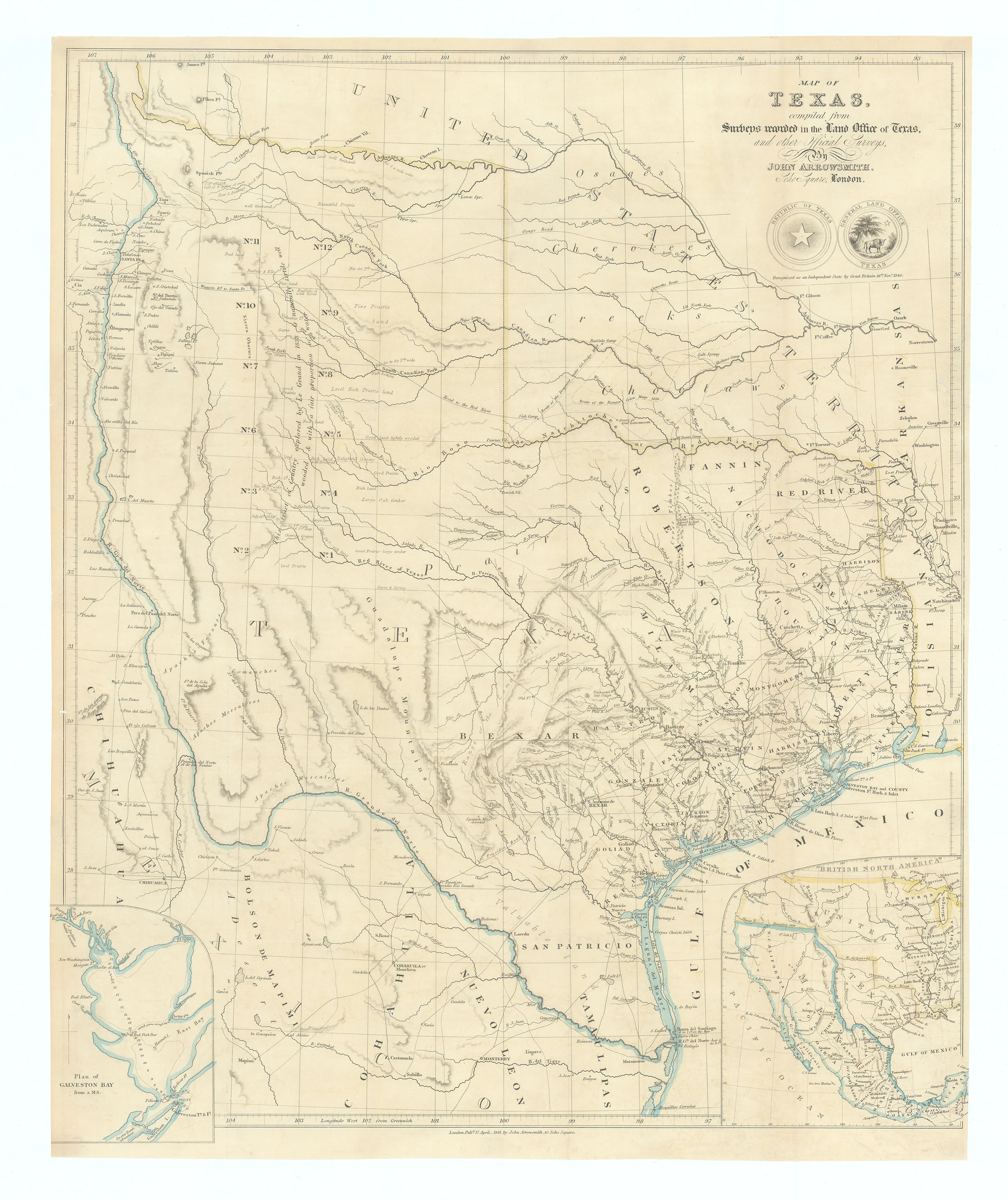
Map of Texas, compiled from Surveys...: Arrowsmith, 1841
-
Title: Map of Texas, compiled from Surveys recorded in the Land Office of Texas, and other Official Surveys...
- Author: John Arrowsmith
- Date: 1841
- Condition: Excellent - Remnants of early hinge mounts on verso, with only very minor tears throughout, all expertly repaired.
- Inches: 20 x 24 1/2 [Paper]
- Centimeters: 50.80 x 62.23 [Paper]
- Product ID: 308674
Seminal Map of the Republic of Texas
Map of the Republic of Texas, issued at the height of British interest in the young republic. It is both a political statement of Texas’s expansive claims and a carefully compiled land office map aimed at prospective investors and emigrants.
Shows the Republic of Texas at its most ambitious extent, with the western boundary carried all the way to the upper Rio Grande, encompassing what is now eastern New Mexico, parts of Colorado, and even touching Wyoming in the claim. Within Texas proper, Arrowsmith delineates the original twenty three counties and the newer western and coastal counties formed by 1839, along with Indian tribes, a dense network of rivers, creeks, and emerging towns. Throughout the interior he adds descriptive notes—comments on soil quality, grazing, timber, and “good prairie” or “rich land”—that read almost like marginalia for emigrants assessing agricultural and speculative prospects.
Arrowsmith explicitly cites the General Land Office of Texas and “other official surveys,” and he synthesized Texan government surveys, rival commercial maps, and travelers’ accounts into what was, for 1841, one of the most authoritative depictions available. The engraving is characteristically clean and elegant, typical for the Arrowsmith firm: fine line work, restrained but clear hachuring to suggest relief, and a spare title block, with no decorative vignettes to distract from the geographic information. Two inset maps being a plan of Galveston Bay and one of western North America from lower Canada to Central America with Republic of Texas outlined.
With a printed note under the Republic of Texas and Texas General Land office seals stating that Great Britain recognized Texas as an independent nation. The map aimed to legitimize Texas as a sovereign republic, support diplomatic recognition, and encourage emigration. As inserted into Kennedy’s highly promotional two volume work, the map functioned as a visual companion to his argument for Texas’s resources, climate, and commercial potential.
Background on Creator
John Arrowsmith (1790–1873) was a renowned British cartographer of the 19th century and a founding member of the Royal Geographical Society. His London Atlas of Universal Geography was one of the most influential of the period, and later versions (1842 and after) with the map of Texas are highly prized by institutions and collectors. He was the nephew of Aaron Arrowsmith and a member of one of the most prolific and accomplished cartographic families.
John Arrowsmith is known for his detailed and accurate maps. He produced a variety of maps, atlases, and globes, and his work was highly regarded for its quality and precision. Arrowsmith's maps were used for various purposes, including exploration, navigation, and geography education. His maps of the world and various regions were influential in their time and contributed to a better understanding of the geography of the 19th century.
One of his most significant works is the "Arrowsmith Atlas," which was published in several editions and contained a collection of maps covering different parts of the world. His contributions to cartography played a vital role in the dissemination of geographic knowledge during the 19th century.
William Kennedy
William Kennedy (1799–1871) was an Irish born poet, journalist, travel writer, and British diplomat best known in Texas history for his influential 1841 work, “Texas: The Rise, Progress, and Prospects of the Republic of Texas.”
References
Amon Carter Museum, Crossroads of Empire: Early Printed Maps of Texas and the Southwest, 1513-1900. p. 33
Dictionary of National Biography (1885–1900), Kennedy, William (1799–1871)
The Portal to Texas History / University of North Texas, Map of Texas: compiled from surveys recorded in the Land Office of Texas, and other official surveys
Streeter Texas 1373A
Wheat 451
Martin & Martin 32
-
Title: Map of Texas, compiled from Surveys recorded in the Land Office of Texas, and other Official Surveys...
- Author: John Arrowsmith
- Date: 1841
- Condition: Excellent - Remnants of early hinge mounts on verso, with only very minor tears throughout, all expertly repaired.
- Inches: 20 x 24 1/2 [Paper]
- Centimeters: 50.80 x 62.23 [Paper]
- Product ID: 308674
Seminal Map of the Republic of Texas
Map of the Republic of Texas, issued at the height of British interest in the young republic. It is both a political statement of Texas’s expansive claims and a carefully compiled land office map aimed at prospective investors and emigrants.
Shows the Republic of Texas at its most ambitious extent, with the western boundary carried all the way to the upper Rio Grande, encompassing what is now eastern New Mexico, parts of Colorado, and even touching Wyoming in the claim. Within Texas proper, Arrowsmith delineates the original twenty three counties and the newer western and coastal counties formed by 1839, along with Indian tribes, a dense network of rivers, creeks, and emerging towns. Throughout the interior he adds descriptive notes—comments on soil quality, grazing, timber, and “good prairie” or “rich land”—that read almost like marginalia for emigrants assessing agricultural and speculative prospects.
Arrowsmith explicitly cites the General Land Office of Texas and “other official surveys,” and he synthesized Texan government surveys, rival commercial maps, and travelers’ accounts into what was, for 1841, one of the most authoritative depictions available. The engraving is characteristically clean and elegant, typical for the Arrowsmith firm: fine line work, restrained but clear hachuring to suggest relief, and a spare title block, with no decorative vignettes to distract from the geographic information. Two inset maps being a plan of Galveston Bay and one of western North America from lower Canada to Central America with Republic of Texas outlined.
With a printed note under the Republic of Texas and Texas General Land office seals stating that Great Britain recognized Texas as an independent nation. The map aimed to legitimize Texas as a sovereign republic, support diplomatic recognition, and encourage emigration. As inserted into Kennedy’s highly promotional two volume work, the map functioned as a visual companion to his argument for Texas’s resources, climate, and commercial potential.
Background on Creator
John Arrowsmith (1790–1873) was a renowned British cartographer of the 19th century and a founding member of the Royal Geographical Society. His London Atlas of Universal Geography was one of the most influential of the period, and later versions (1842 and after) with the map of Texas are highly prized by institutions and collectors. He was the nephew of Aaron Arrowsmith and a member of one of the most prolific and accomplished cartographic families.
John Arrowsmith is known for his detailed and accurate maps. He produced a variety of maps, atlases, and globes, and his work was highly regarded for its quality and precision. Arrowsmith's maps were used for various purposes, including exploration, navigation, and geography education. His maps of the world and various regions were influential in their time and contributed to a better understanding of the geography of the 19th century.
One of his most significant works is the "Arrowsmith Atlas," which was published in several editions and contained a collection of maps covering different parts of the world. His contributions to cartography played a vital role in the dissemination of geographic knowledge during the 19th century.
William Kennedy
William Kennedy (1799–1871) was an Irish born poet, journalist, travel writer, and British diplomat best known in Texas history for his influential 1841 work, “Texas: The Rise, Progress, and Prospects of the Republic of Texas.”
References
Amon Carter Museum, Crossroads of Empire: Early Printed Maps of Texas and the Southwest, 1513-1900. p. 33
Dictionary of National Biography (1885–1900), Kennedy, William (1799–1871)
The Portal to Texas History / University of North Texas, Map of Texas: compiled from surveys recorded in the Land Office of Texas, and other official surveys
Streeter Texas 1373A
Wheat 451
Martin & Martin 32
Original: $11,000.00
-65%$11,000.00
$3,850.00Description
-
Title: Map of Texas, compiled from Surveys recorded in the Land Office of Texas, and other Official Surveys...
- Author: John Arrowsmith
- Date: 1841
- Condition: Excellent - Remnants of early hinge mounts on verso, with only very minor tears throughout, all expertly repaired.
- Inches: 20 x 24 1/2 [Paper]
- Centimeters: 50.80 x 62.23 [Paper]
- Product ID: 308674
Seminal Map of the Republic of Texas
Map of the Republic of Texas, issued at the height of British interest in the young republic. It is both a political statement of Texas’s expansive claims and a carefully compiled land office map aimed at prospective investors and emigrants.
Shows the Republic of Texas at its most ambitious extent, with the western boundary carried all the way to the upper Rio Grande, encompassing what is now eastern New Mexico, parts of Colorado, and even touching Wyoming in the claim. Within Texas proper, Arrowsmith delineates the original twenty three counties and the newer western and coastal counties formed by 1839, along with Indian tribes, a dense network of rivers, creeks, and emerging towns. Throughout the interior he adds descriptive notes—comments on soil quality, grazing, timber, and “good prairie” or “rich land”—that read almost like marginalia for emigrants assessing agricultural and speculative prospects.
Arrowsmith explicitly cites the General Land Office of Texas and “other official surveys,” and he synthesized Texan government surveys, rival commercial maps, and travelers’ accounts into what was, for 1841, one of the most authoritative depictions available. The engraving is characteristically clean and elegant, typical for the Arrowsmith firm: fine line work, restrained but clear hachuring to suggest relief, and a spare title block, with no decorative vignettes to distract from the geographic information. Two inset maps being a plan of Galveston Bay and one of western North America from lower Canada to Central America with Republic of Texas outlined.
With a printed note under the Republic of Texas and Texas General Land office seals stating that Great Britain recognized Texas as an independent nation. The map aimed to legitimize Texas as a sovereign republic, support diplomatic recognition, and encourage emigration. As inserted into Kennedy’s highly promotional two volume work, the map functioned as a visual companion to his argument for Texas’s resources, climate, and commercial potential.
Background on Creator
John Arrowsmith (1790–1873) was a renowned British cartographer of the 19th century and a founding member of the Royal Geographical Society. His London Atlas of Universal Geography was one of the most influential of the period, and later versions (1842 and after) with the map of Texas are highly prized by institutions and collectors. He was the nephew of Aaron Arrowsmith and a member of one of the most prolific and accomplished cartographic families.
John Arrowsmith is known for his detailed and accurate maps. He produced a variety of maps, atlases, and globes, and his work was highly regarded for its quality and precision. Arrowsmith's maps were used for various purposes, including exploration, navigation, and geography education. His maps of the world and various regions were influential in their time and contributed to a better understanding of the geography of the 19th century.
One of his most significant works is the "Arrowsmith Atlas," which was published in several editions and contained a collection of maps covering different parts of the world. His contributions to cartography played a vital role in the dissemination of geographic knowledge during the 19th century.
William Kennedy
William Kennedy (1799–1871) was an Irish born poet, journalist, travel writer, and British diplomat best known in Texas history for his influential 1841 work, “Texas: The Rise, Progress, and Prospects of the Republic of Texas.”
References
Amon Carter Museum, Crossroads of Empire: Early Printed Maps of Texas and the Southwest, 1513-1900. p. 33
Dictionary of National Biography (1885–1900), Kennedy, William (1799–1871)
The Portal to Texas History / University of North Texas, Map of Texas: compiled from surveys recorded in the Land Office of Texas, and other official surveys
Streeter Texas 1373A
Wheat 451
Martin & Martin 32











