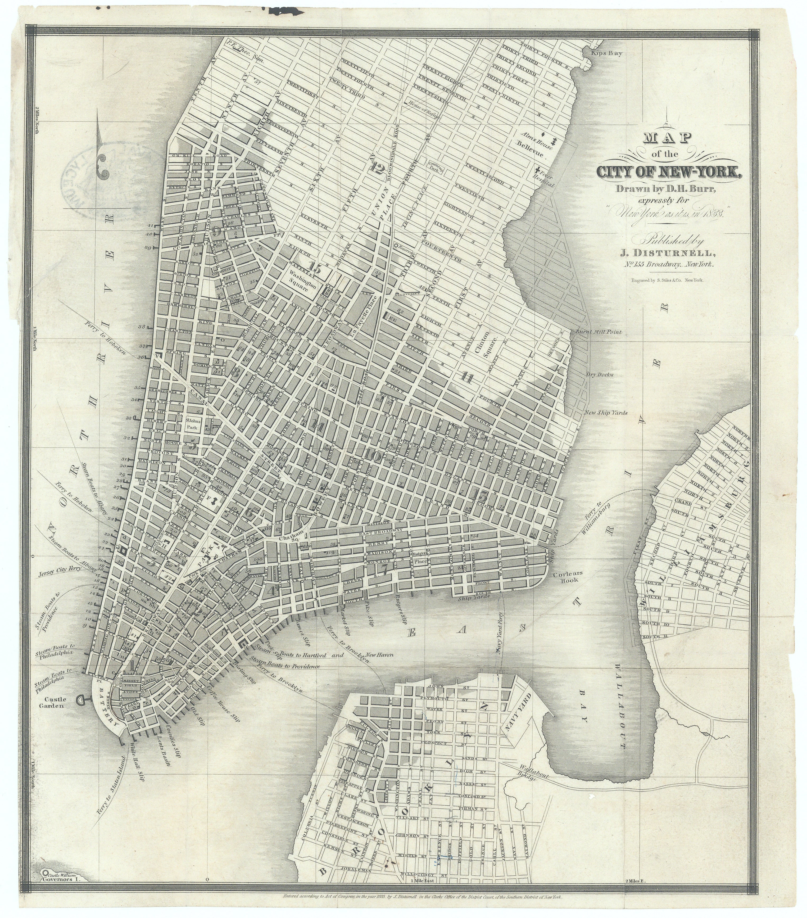
Map of the City of New York...: Burr & Disturnell, 1833
-
Title: Map of the City of New York Drawn by D.H. Burr, expressly for "New York as it is in 1833." With Advertising Directory
- Author: David H. Burr, John Disturnell
- Date: 1833
- Condition: See description below
- Inches: 10 x 11 3/4 [Image]
- Centimeters: 25.4 x 29.84 [Paper]
- Product ID: 308479
First Edition, Extremely Rare & Early Guidebook of New York City
This highly detailed map was specifically commissioned for the guidebook "New York as it is in 1833," edited by Edwin Williams, reflecting the city's layout and significant features at that time. Burr's map captures the expanding urban grid of Manhattan, showing streets, avenues, and key public spaces, as well as the waterfronts and ferry routes that were vital to the city's commerce and daily life.
The map is notable for its clarity and precision, characteristic of Burr's cartographic style, and likely includes labeled wards, prominent buildings, churches, markets, and perhaps the boundaries of the city as they existed in the early 1830s. The map would have served both residents and visitors, providing an authoritative reference for navigating New York City during a period of rapid growth and transformation. Burr's work on this and other maps of New York was highly regarded and contributed to his reputation as one of the leading American mapmakers of his era.
Hand stamped on verso within an oval: U.S. NAVAL LYCEUM depicting a full-rigged sailing ship. The U.S. Naval Lyceum was a historical institution established in 1833 at the Brooklyn Navy Yard to promote intellectual and professional development among naval officers. It served as a center for learning, boasting a library, museum, and even a short-lived journal called Naval Magazine. The Lyceum also played a key role in advocating for the establishment of a formal Naval Academy. Its collections and records are now housed at the U.S. Naval Academy Museum in Annapolis.
Background on Creator(s)
David H. Burr (1803–1875) was a prominent American cartographer, surveyor, and topographer who played a significant role in early American mapmaking. Born in Bridgeport, Connecticut, in August 1803, Burr initially studied law and became a lawyer after passing the New York Bar, but soon shifted his focus to surveying and cartography. He began his surveying career under Simeon De Witt, the Surveyor General of New York, and was instrumental in mapping New York’s rapidly developing infrastructure during the early 19th century.
John Disturnell (1801–1877) was a prominent American mapmaker, publisher, and bookseller in the 19th century, best known for producing detailed maps and travel guides during a period of rapid expansion and development in the United States. His most historically significant work was the 1847 "Mapa de los Estados Unidos de Méjico" (Map of the United States of Mexico), which played a pivotal role in the negotiations of the Treaty of Guadalupe Hidalgo that ended the Mexican-American War and established the new boundary between the United States and Mexico.
Condition
Original cloth covers with title stamped in gilt on spine, age related toning throughout book. Map removed from cover, presenting issued folds. 1" tear into upper left of image, expertly repaired.
-
Title: Map of the City of New York Drawn by D.H. Burr, expressly for "New York as it is in 1833." With Advertising Directory
- Author: David H. Burr, John Disturnell
- Date: 1833
- Condition: See description below
- Inches: 10 x 11 3/4 [Image]
- Centimeters: 25.4 x 29.84 [Paper]
- Product ID: 308479
First Edition, Extremely Rare & Early Guidebook of New York City
This highly detailed map was specifically commissioned for the guidebook "New York as it is in 1833," edited by Edwin Williams, reflecting the city's layout and significant features at that time. Burr's map captures the expanding urban grid of Manhattan, showing streets, avenues, and key public spaces, as well as the waterfronts and ferry routes that were vital to the city's commerce and daily life.
The map is notable for its clarity and precision, characteristic of Burr's cartographic style, and likely includes labeled wards, prominent buildings, churches, markets, and perhaps the boundaries of the city as they existed in the early 1830s. The map would have served both residents and visitors, providing an authoritative reference for navigating New York City during a period of rapid growth and transformation. Burr's work on this and other maps of New York was highly regarded and contributed to his reputation as one of the leading American mapmakers of his era.
Hand stamped on verso within an oval: U.S. NAVAL LYCEUM depicting a full-rigged sailing ship. The U.S. Naval Lyceum was a historical institution established in 1833 at the Brooklyn Navy Yard to promote intellectual and professional development among naval officers. It served as a center for learning, boasting a library, museum, and even a short-lived journal called Naval Magazine. The Lyceum also played a key role in advocating for the establishment of a formal Naval Academy. Its collections and records are now housed at the U.S. Naval Academy Museum in Annapolis.
Background on Creator(s)
David H. Burr (1803–1875) was a prominent American cartographer, surveyor, and topographer who played a significant role in early American mapmaking. Born in Bridgeport, Connecticut, in August 1803, Burr initially studied law and became a lawyer after passing the New York Bar, but soon shifted his focus to surveying and cartography. He began his surveying career under Simeon De Witt, the Surveyor General of New York, and was instrumental in mapping New York’s rapidly developing infrastructure during the early 19th century.
John Disturnell (1801–1877) was a prominent American mapmaker, publisher, and bookseller in the 19th century, best known for producing detailed maps and travel guides during a period of rapid expansion and development in the United States. His most historically significant work was the 1847 "Mapa de los Estados Unidos de Méjico" (Map of the United States of Mexico), which played a pivotal role in the negotiations of the Treaty of Guadalupe Hidalgo that ended the Mexican-American War and established the new boundary between the United States and Mexico.
Condition
Original cloth covers with title stamped in gilt on spine, age related toning throughout book. Map removed from cover, presenting issued folds. 1" tear into upper left of image, expertly repaired.
Description
-
Title: Map of the City of New York Drawn by D.H. Burr, expressly for "New York as it is in 1833." With Advertising Directory
- Author: David H. Burr, John Disturnell
- Date: 1833
- Condition: See description below
- Inches: 10 x 11 3/4 [Image]
- Centimeters: 25.4 x 29.84 [Paper]
- Product ID: 308479
First Edition, Extremely Rare & Early Guidebook of New York City
This highly detailed map was specifically commissioned for the guidebook "New York as it is in 1833," edited by Edwin Williams, reflecting the city's layout and significant features at that time. Burr's map captures the expanding urban grid of Manhattan, showing streets, avenues, and key public spaces, as well as the waterfronts and ferry routes that were vital to the city's commerce and daily life.
The map is notable for its clarity and precision, characteristic of Burr's cartographic style, and likely includes labeled wards, prominent buildings, churches, markets, and perhaps the boundaries of the city as they existed in the early 1830s. The map would have served both residents and visitors, providing an authoritative reference for navigating New York City during a period of rapid growth and transformation. Burr's work on this and other maps of New York was highly regarded and contributed to his reputation as one of the leading American mapmakers of his era.
Hand stamped on verso within an oval: U.S. NAVAL LYCEUM depicting a full-rigged sailing ship. The U.S. Naval Lyceum was a historical institution established in 1833 at the Brooklyn Navy Yard to promote intellectual and professional development among naval officers. It served as a center for learning, boasting a library, museum, and even a short-lived journal called Naval Magazine. The Lyceum also played a key role in advocating for the establishment of a formal Naval Academy. Its collections and records are now housed at the U.S. Naval Academy Museum in Annapolis.
Background on Creator(s)
David H. Burr (1803–1875) was a prominent American cartographer, surveyor, and topographer who played a significant role in early American mapmaking. Born in Bridgeport, Connecticut, in August 1803, Burr initially studied law and became a lawyer after passing the New York Bar, but soon shifted his focus to surveying and cartography. He began his surveying career under Simeon De Witt, the Surveyor General of New York, and was instrumental in mapping New York’s rapidly developing infrastructure during the early 19th century.
John Disturnell (1801–1877) was a prominent American mapmaker, publisher, and bookseller in the 19th century, best known for producing detailed maps and travel guides during a period of rapid expansion and development in the United States. His most historically significant work was the 1847 "Mapa de los Estados Unidos de Méjico" (Map of the United States of Mexico), which played a pivotal role in the negotiations of the Treaty of Guadalupe Hidalgo that ended the Mexican-American War and established the new boundary between the United States and Mexico.
Condition
Original cloth covers with title stamped in gilt on spine, age related toning throughout book. Map removed from cover, presenting issued folds. 1" tear into upper left of image, expertly repaired.











