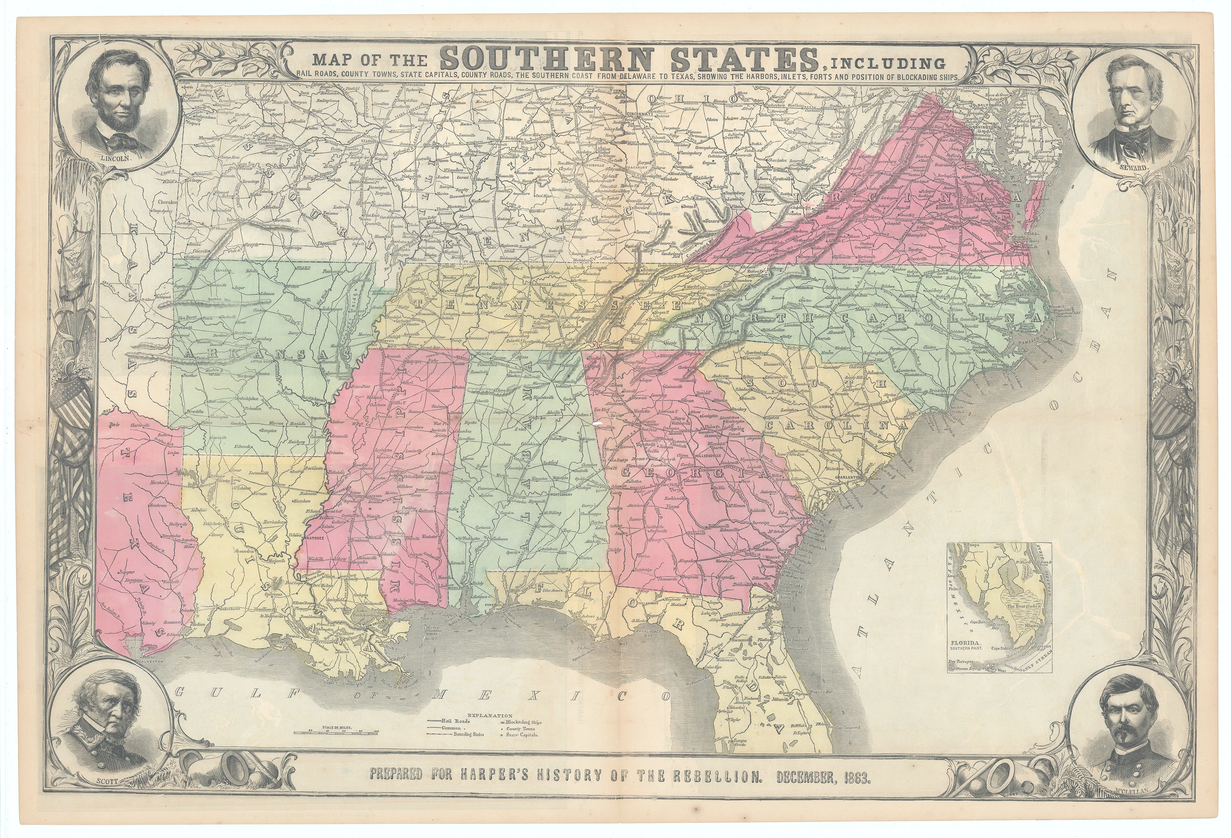
Map of the Southern States...: Harper & Brothers, 1863
-
Title: MAP OF THE SOUTHERN STATES, INCLUDING RAILROADS, COUNTY TOWNS, STATE CAPITALS, COUNTY ROADS, THE SOUTHERN COAST FROM DELAWARE TO TEXAS, SHOWING THE HARBORS, INLETS, FORTS AND POSITION OF BLOCKADING SHIPS
- Author: Harper & Brothers
- Date: December, 1863
- Condition: Good - original folds as issued, minimal paper loss at centerfold, and small tears throughout; expertly repaired
- Inches: 30 1/4 x 20 [Image]
- Centimeters: 76.83 x 50.80 [Image]
- Product ID: 308571
This outstanding Civil War map, prepared for Harper’s History of the Rebellion in December 1863, presents a wealth of detail, capturing towns, villages, rail lines, and the extensive Union naval blockade along the southern coastline in remarkable clarity. Elegantly framed by an ornate decorative border, the map features finely engraved portrait medallions of Abraham Lincoln, William Seward, General Winfield Scott, and General George B. McClellan at each corner, emphasizing the national significance of the conflict.
A dedicated inset at the lower right highlights the southern portion of Florida, while the verso showcases three dramatic black and white wood-engraved bird’s-eye views—including two single-page illustrations and a sweeping double-page panorama of the Chesapeake Bay region labeled “Pictorial Map of Portions of Delaware, Maryland, Virginia, and North Carolina,” as well as aerial perspectives titled “Balloon View of Fortress Monroe and Hampton Roads” and “Balloon View of the Seat of War,” making this a rare and visually compelling Civil War artifact.
Background on Creator
Harper & Brothers was founded in New York City in 1817 by James and John Harper as J. & J. Harper, with their younger brothers Joseph Wesley and Fletcher joining in the 1820s, and the firm adopting the name Harper & Brothers in 1833. Renowned for their early leadership in industrial publishing, Harper & Brothers shaped American mass culture by producing influential illustrated works, textbooks, and reference books, and became especially prominent after launching major periodicals including Harper’s New Monthly Magazine (1850), Harper’s Weekly (1857), and Harper’s Bazar (1867). The company thrived through the late nineteenth century, producing widely read literature and pioneering advances in printing, and eventually merged with Row, Peterson & Company in 1962 to form Harper & Row; the modern-day successor is HarperCollins, one of the world’s largest publishing houses.
-
Title: MAP OF THE SOUTHERN STATES, INCLUDING RAILROADS, COUNTY TOWNS, STATE CAPITALS, COUNTY ROADS, THE SOUTHERN COAST FROM DELAWARE TO TEXAS, SHOWING THE HARBORS, INLETS, FORTS AND POSITION OF BLOCKADING SHIPS
- Author: Harper & Brothers
- Date: December, 1863
- Condition: Good - original folds as issued, minimal paper loss at centerfold, and small tears throughout; expertly repaired
- Inches: 30 1/4 x 20 [Image]
- Centimeters: 76.83 x 50.80 [Image]
- Product ID: 308571
This outstanding Civil War map, prepared for Harper’s History of the Rebellion in December 1863, presents a wealth of detail, capturing towns, villages, rail lines, and the extensive Union naval blockade along the southern coastline in remarkable clarity. Elegantly framed by an ornate decorative border, the map features finely engraved portrait medallions of Abraham Lincoln, William Seward, General Winfield Scott, and General George B. McClellan at each corner, emphasizing the national significance of the conflict.
A dedicated inset at the lower right highlights the southern portion of Florida, while the verso showcases three dramatic black and white wood-engraved bird’s-eye views—including two single-page illustrations and a sweeping double-page panorama of the Chesapeake Bay region labeled “Pictorial Map of Portions of Delaware, Maryland, Virginia, and North Carolina,” as well as aerial perspectives titled “Balloon View of Fortress Monroe and Hampton Roads” and “Balloon View of the Seat of War,” making this a rare and visually compelling Civil War artifact.
Background on Creator
Harper & Brothers was founded in New York City in 1817 by James and John Harper as J. & J. Harper, with their younger brothers Joseph Wesley and Fletcher joining in the 1820s, and the firm adopting the name Harper & Brothers in 1833. Renowned for their early leadership in industrial publishing, Harper & Brothers shaped American mass culture by producing influential illustrated works, textbooks, and reference books, and became especially prominent after launching major periodicals including Harper’s New Monthly Magazine (1850), Harper’s Weekly (1857), and Harper’s Bazar (1867). The company thrived through the late nineteenth century, producing widely read literature and pioneering advances in printing, and eventually merged with Row, Peterson & Company in 1962 to form Harper & Row; the modern-day successor is HarperCollins, one of the world’s largest publishing houses.
Original: $295.00
-65%$295.00
$103.25Description
-
Title: MAP OF THE SOUTHERN STATES, INCLUDING RAILROADS, COUNTY TOWNS, STATE CAPITALS, COUNTY ROADS, THE SOUTHERN COAST FROM DELAWARE TO TEXAS, SHOWING THE HARBORS, INLETS, FORTS AND POSITION OF BLOCKADING SHIPS
- Author: Harper & Brothers
- Date: December, 1863
- Condition: Good - original folds as issued, minimal paper loss at centerfold, and small tears throughout; expertly repaired
- Inches: 30 1/4 x 20 [Image]
- Centimeters: 76.83 x 50.80 [Image]
- Product ID: 308571
This outstanding Civil War map, prepared for Harper’s History of the Rebellion in December 1863, presents a wealth of detail, capturing towns, villages, rail lines, and the extensive Union naval blockade along the southern coastline in remarkable clarity. Elegantly framed by an ornate decorative border, the map features finely engraved portrait medallions of Abraham Lincoln, William Seward, General Winfield Scott, and General George B. McClellan at each corner, emphasizing the national significance of the conflict.
A dedicated inset at the lower right highlights the southern portion of Florida, while the verso showcases three dramatic black and white wood-engraved bird’s-eye views—including two single-page illustrations and a sweeping double-page panorama of the Chesapeake Bay region labeled “Pictorial Map of Portions of Delaware, Maryland, Virginia, and North Carolina,” as well as aerial perspectives titled “Balloon View of Fortress Monroe and Hampton Roads” and “Balloon View of the Seat of War,” making this a rare and visually compelling Civil War artifact.
Background on Creator
Harper & Brothers was founded in New York City in 1817 by James and John Harper as J. & J. Harper, with their younger brothers Joseph Wesley and Fletcher joining in the 1820s, and the firm adopting the name Harper & Brothers in 1833. Renowned for their early leadership in industrial publishing, Harper & Brothers shaped American mass culture by producing influential illustrated works, textbooks, and reference books, and became especially prominent after launching major periodicals including Harper’s New Monthly Magazine (1850), Harper’s Weekly (1857), and Harper’s Bazar (1867). The company thrived through the late nineteenth century, producing widely read literature and pioneering advances in printing, and eventually merged with Row, Peterson & Company in 1962 to form Harper & Row; the modern-day successor is HarperCollins, one of the world’s largest publishing houses.











