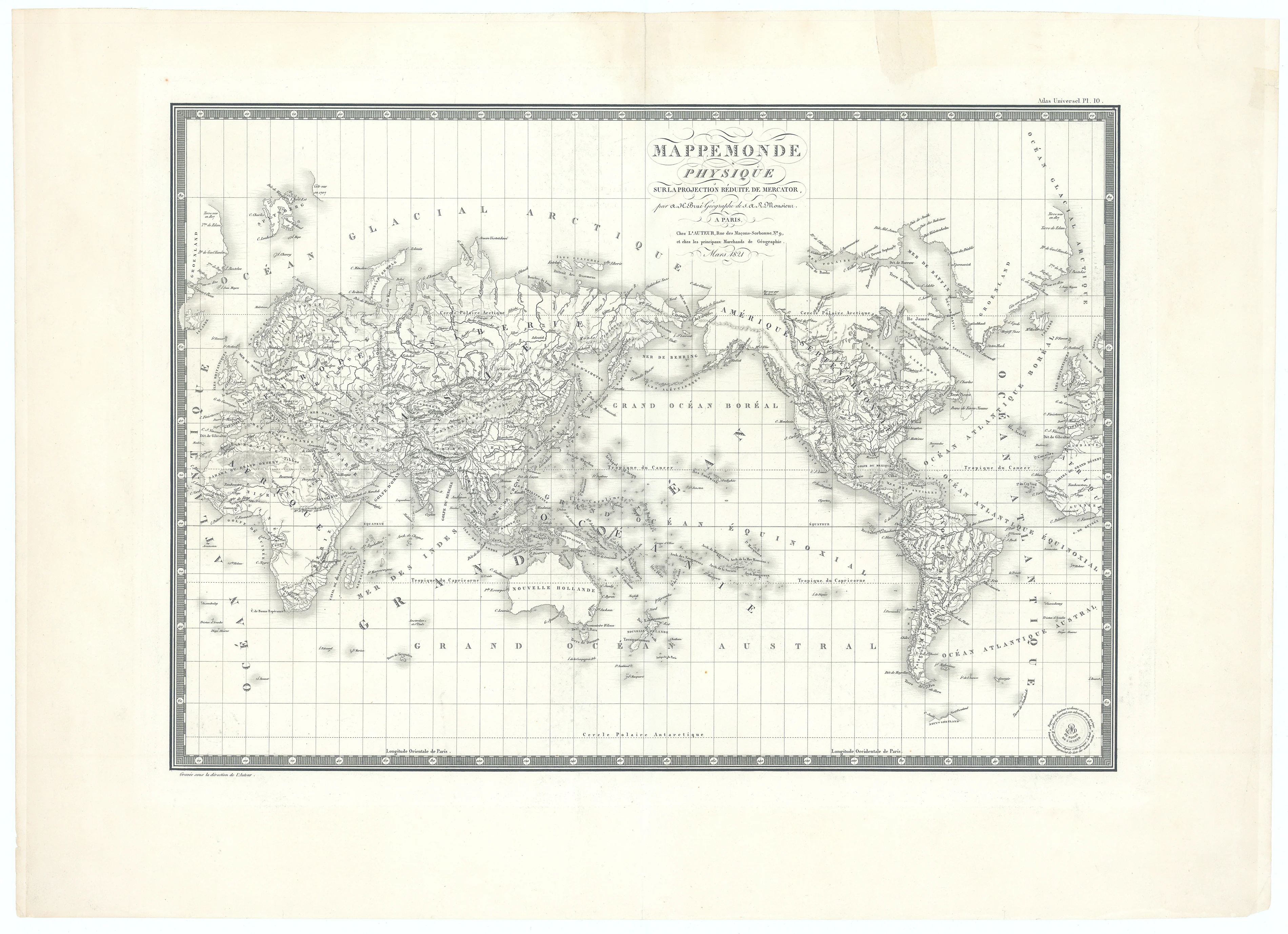
Mappe Monde Physique...: Brue, 1821
-
Title: MAPPE MONDE PHYSIQUE | Surla Projection Reduite De Mercator
- Author: Adrien-Hubert Brue
- Date: 1821
- Condition: Excellent - centerfold as issued, slight tear at top margin; expertly repaired
- Inches: 20 1/8 x 14 1/4 [Image]
- Centimeters: 51.11 x 36.19 [Image]
- Product ID: 308569
This striking 1821 map titled “Mappemonde Physique sur la Projection dite de Mercator,” created by Adrien-Hubert Brue, presents a meticulously engraved physical world map rendered entirely in black and white, with exquisite attention to geographic detail. The map employs Mercator’s projection, resulting in a rectilinear grid defined by precisely graduated latitude and longitude scales that frame the composition on all sides. Relief and terrain features are shown with finely executed hachuring, capturing mountain ranges, river valleys, deserts, plateaus, and coastal formations, while a dense network of labeled topographic elements provides comprehensive global coverage—from the “Glacial Arctic” regions at the top to the “Grand Ocean Austral” across the lower expanse.
Prominent ocean basins—including the “Grand Océan Boréal” and “Océan Atlantique Austral”—are clearly identified, and the continents are richly annotated with both physical and select political details, emphasizing the map’s scientific intent to communicate earth’s major landforms rather than administrative divisions. The map includes the publisher’s engraved seal in the lower right, Brue’s authorship in elegant script, and a sophisticated decorative border that further distinguishes the map as an example of early 19th-century French cartographic artistry.
Background on Creator
Adrien-Hubert Brué (1786 – 1832) made significant contributions to geographical mapping through his detailed and accurate cartographic work. He began his career in cartography after serving on various ships, including the Baudin Expedition to the South Pacific. Brué's maps were known for their clarity and precision, which earned him the prestigious title of Geographe du Roi. In this capacity, he contributed to thousands of maps and numerous atlases. One of his notable works is the Grand Atlas Universel, published in 1816, which included 50 large-scale maps of all continents, showcasing his comprehensive approach to mapping.
Brué’s maps continued to be influential even after his death, with updates and republications occurring decades later. His widow initially published several maps posthumously before selling his work to his partner's heir, ensuring that Brué's contributions to cartography endured well beyond his lifetime.
-
Title: MAPPE MONDE PHYSIQUE | Surla Projection Reduite De Mercator
- Author: Adrien-Hubert Brue
- Date: 1821
- Condition: Excellent - centerfold as issued, slight tear at top margin; expertly repaired
- Inches: 20 1/8 x 14 1/4 [Image]
- Centimeters: 51.11 x 36.19 [Image]
- Product ID: 308569
This striking 1821 map titled “Mappemonde Physique sur la Projection dite de Mercator,” created by Adrien-Hubert Brue, presents a meticulously engraved physical world map rendered entirely in black and white, with exquisite attention to geographic detail. The map employs Mercator’s projection, resulting in a rectilinear grid defined by precisely graduated latitude and longitude scales that frame the composition on all sides. Relief and terrain features are shown with finely executed hachuring, capturing mountain ranges, river valleys, deserts, plateaus, and coastal formations, while a dense network of labeled topographic elements provides comprehensive global coverage—from the “Glacial Arctic” regions at the top to the “Grand Ocean Austral” across the lower expanse.
Prominent ocean basins—including the “Grand Océan Boréal” and “Océan Atlantique Austral”—are clearly identified, and the continents are richly annotated with both physical and select political details, emphasizing the map’s scientific intent to communicate earth’s major landforms rather than administrative divisions. The map includes the publisher’s engraved seal in the lower right, Brue’s authorship in elegant script, and a sophisticated decorative border that further distinguishes the map as an example of early 19th-century French cartographic artistry.
Background on Creator
Adrien-Hubert Brué (1786 – 1832) made significant contributions to geographical mapping through his detailed and accurate cartographic work. He began his career in cartography after serving on various ships, including the Baudin Expedition to the South Pacific. Brué's maps were known for their clarity and precision, which earned him the prestigious title of Geographe du Roi. In this capacity, he contributed to thousands of maps and numerous atlases. One of his notable works is the Grand Atlas Universel, published in 1816, which included 50 large-scale maps of all continents, showcasing his comprehensive approach to mapping.
Brué’s maps continued to be influential even after his death, with updates and republications occurring decades later. His widow initially published several maps posthumously before selling his work to his partner's heir, ensuring that Brué's contributions to cartography endured well beyond his lifetime.
Original: $395.00
-65%$395.00
$138.25Description
-
Title: MAPPE MONDE PHYSIQUE | Surla Projection Reduite De Mercator
- Author: Adrien-Hubert Brue
- Date: 1821
- Condition: Excellent - centerfold as issued, slight tear at top margin; expertly repaired
- Inches: 20 1/8 x 14 1/4 [Image]
- Centimeters: 51.11 x 36.19 [Image]
- Product ID: 308569
This striking 1821 map titled “Mappemonde Physique sur la Projection dite de Mercator,” created by Adrien-Hubert Brue, presents a meticulously engraved physical world map rendered entirely in black and white, with exquisite attention to geographic detail. The map employs Mercator’s projection, resulting in a rectilinear grid defined by precisely graduated latitude and longitude scales that frame the composition on all sides. Relief and terrain features are shown with finely executed hachuring, capturing mountain ranges, river valleys, deserts, plateaus, and coastal formations, while a dense network of labeled topographic elements provides comprehensive global coverage—from the “Glacial Arctic” regions at the top to the “Grand Ocean Austral” across the lower expanse.
Prominent ocean basins—including the “Grand Océan Boréal” and “Océan Atlantique Austral”—are clearly identified, and the continents are richly annotated with both physical and select political details, emphasizing the map’s scientific intent to communicate earth’s major landforms rather than administrative divisions. The map includes the publisher’s engraved seal in the lower right, Brue’s authorship in elegant script, and a sophisticated decorative border that further distinguishes the map as an example of early 19th-century French cartographic artistry.
Background on Creator
Adrien-Hubert Brué (1786 – 1832) made significant contributions to geographical mapping through his detailed and accurate cartographic work. He began his career in cartography after serving on various ships, including the Baudin Expedition to the South Pacific. Brué's maps were known for their clarity and precision, which earned him the prestigious title of Geographe du Roi. In this capacity, he contributed to thousands of maps and numerous atlases. One of his notable works is the Grand Atlas Universel, published in 1816, which included 50 large-scale maps of all continents, showcasing his comprehensive approach to mapping.
Brué’s maps continued to be influential even after his death, with updates and republications occurring decades later. His widow initially published several maps posthumously before selling his work to his partner's heir, ensuring that Brué's contributions to cartography endured well beyond his lifetime.











