Nashville: Cram 1902
- Title: Nashville
- Author: George F. Cram
- Date: 1902
- Medium: Wax engraving
- Condition: Very Good Plus - age toning, small tear and discoloration in left margin
- Inches: 11 1/8 x 14 5/8 [Paper]
- Centimeters: 29.21 x 36.83 [Paper]
- Product ID: 102343
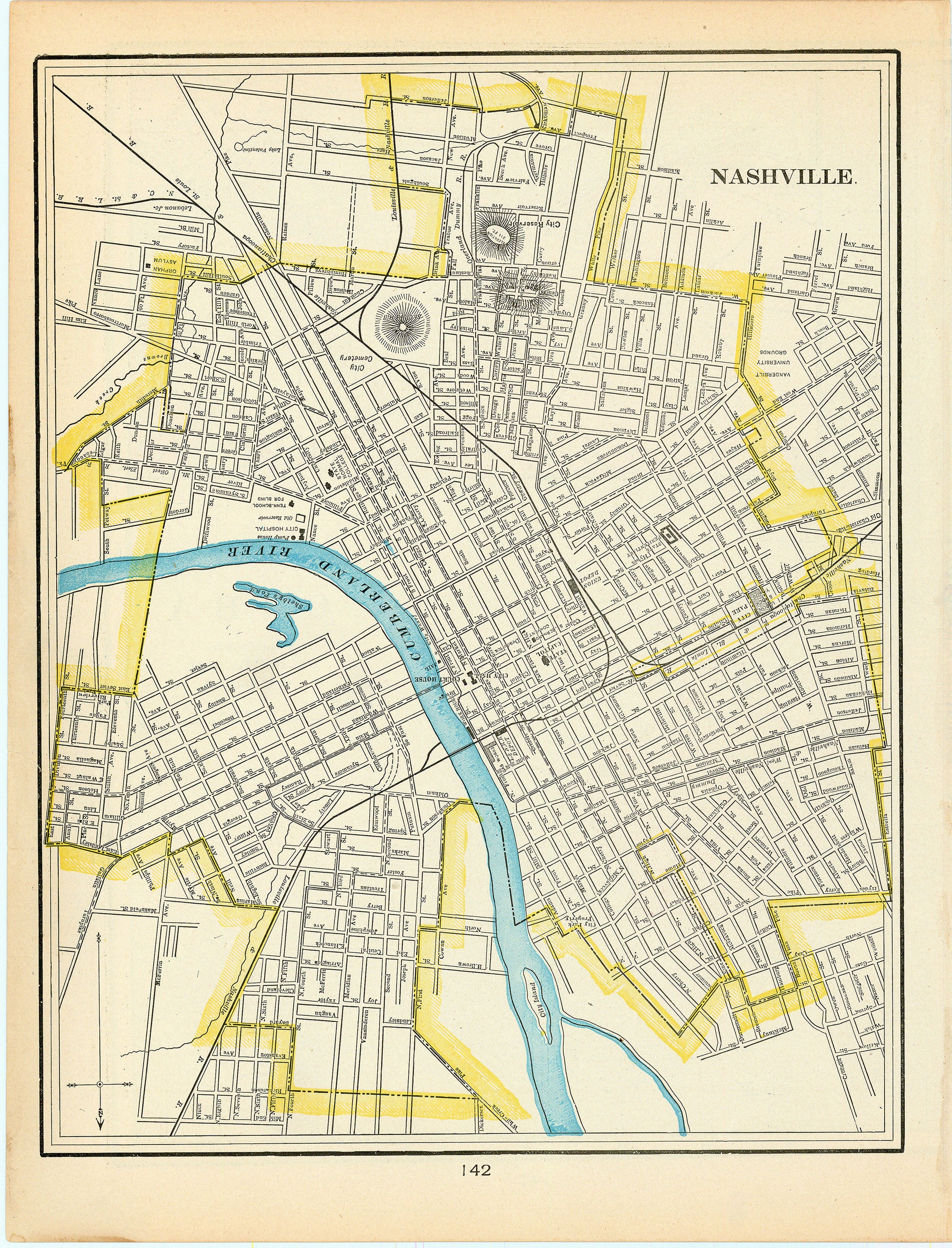
Map of the city of Nashville, Tennessee on the banks of the Cumberland River.
George F. Cram (1842-1928) got his start in cartography following the Civil War when he moved to Evanston, Illinois to clerk for his uncle, a merchant by the name of Rufus Blanchard. Prior to the war, Blanchard had found success selling globes, maps, and books along the east coast until postwar disruption drove him west. Cram had served in the Union Army during the war and supposedly carried out cartographic duties for none other than Ulysses S. Grant. Cram and Blanchard eventually became business partners, founding Blanchard & Cram in 1867. Two years later, Cram would take over the firm in its entirety, moving it to nearby Chicago and rebranding as the George F. Cram Company. Cram also altered his business model, becoming a supplier for travelling book salesmen. However, after the Great Chicago Fire of 1871 destroyed the business, Cram started anew as the Cram Map Depot and returned to selling maps and atlases as he had while in business with Blanchard.
From 1875 onwards, the Cram Map Depot produced numerous atlases and railroad maps of the United States, as well as atlases of Europe documenting the First World War. Though it underwent a few revisions, the company’s enormously-successful Atlas of the World remained in print for over 70 years. In 1920, Cram finally retired at the age of 79, selling the business to E.A. Peterson’s National Map Company. While Peterson initially incorporated Cram’s business into his own company, upon Cram’s death in 1928 he renamed it to the George F. Cram Company, the name it bore until the company closed its doors in 2012.
- Title: Nashville
- Author: George F. Cram
- Date: 1902
- Medium: Wax engraving
- Condition: Very Good Plus - age toning, small tear and discoloration in left margin
- Inches: 11 1/8 x 14 5/8 [Paper]
- Centimeters: 29.21 x 36.83 [Paper]
- Product ID: 102343
Map of the city of Nashville, Tennessee on the banks of the Cumberland River.
George F. Cram (1842-1928) got his start in cartography following the Civil War when he moved to Evanston, Illinois to clerk for his uncle, a merchant by the name of Rufus Blanchard. Prior to the war, Blanchard had found success selling globes, maps, and books along the east coast until postwar disruption drove him west. Cram had served in the Union Army during the war and supposedly carried out cartographic duties for none other than Ulysses S. Grant. Cram and Blanchard eventually became business partners, founding Blanchard & Cram in 1867. Two years later, Cram would take over the firm in its entirety, moving it to nearby Chicago and rebranding as the George F. Cram Company. Cram also altered his business model, becoming a supplier for travelling book salesmen. However, after the Great Chicago Fire of 1871 destroyed the business, Cram started anew as the Cram Map Depot and returned to selling maps and atlases as he had while in business with Blanchard.
From 1875 onwards, the Cram Map Depot produced numerous atlases and railroad maps of the United States, as well as atlases of Europe documenting the First World War. Though it underwent a few revisions, the company’s enormously-successful Atlas of the World remained in print for over 70 years. In 1920, Cram finally retired at the age of 79, selling the business to E.A. Peterson’s National Map Company. While Peterson initially incorporated Cram’s business into his own company, upon Cram’s death in 1928 he renamed it to the George F. Cram Company, the name it bore until the company closed its doors in 2012.
Description
- Title: Nashville
- Author: George F. Cram
- Date: 1902
- Medium: Wax engraving
- Condition: Very Good Plus - age toning, small tear and discoloration in left margin
- Inches: 11 1/8 x 14 5/8 [Paper]
- Centimeters: 29.21 x 36.83 [Paper]
- Product ID: 102343
Map of the city of Nashville, Tennessee on the banks of the Cumberland River.
George F. Cram (1842-1928) got his start in cartography following the Civil War when he moved to Evanston, Illinois to clerk for his uncle, a merchant by the name of Rufus Blanchard. Prior to the war, Blanchard had found success selling globes, maps, and books along the east coast until postwar disruption drove him west. Cram had served in the Union Army during the war and supposedly carried out cartographic duties for none other than Ulysses S. Grant. Cram and Blanchard eventually became business partners, founding Blanchard & Cram in 1867. Two years later, Cram would take over the firm in its entirety, moving it to nearby Chicago and rebranding as the George F. Cram Company. Cram also altered his business model, becoming a supplier for travelling book salesmen. However, after the Great Chicago Fire of 1871 destroyed the business, Cram started anew as the Cram Map Depot and returned to selling maps and atlases as he had while in business with Blanchard.
From 1875 onwards, the Cram Map Depot produced numerous atlases and railroad maps of the United States, as well as atlases of Europe documenting the First World War. Though it underwent a few revisions, the company’s enormously-successful Atlas of the World remained in print for over 70 years. In 1920, Cram finally retired at the age of 79, selling the business to E.A. Peterson’s National Map Company. While Peterson initially incorporated Cram’s business into his own company, upon Cram’s death in 1928 he renamed it to the George F. Cram Company, the name it bore until the company closed its doors in 2012.