Plan of New Orleans the Capital of Louisiana: Benning, 1761
- Title: Plan of New Orleans the Capital of Louisiana
- Author: Robert Benning
- Date: 1761
- Medium: Copperplate engraving
- Condition: See description
- Inches: 9.1 x 6.6 [Image]
- Centimeters: 23.11 x 16.76 [Image]
- Product ID: 308090
The Second English Map of Colonial New Orleans
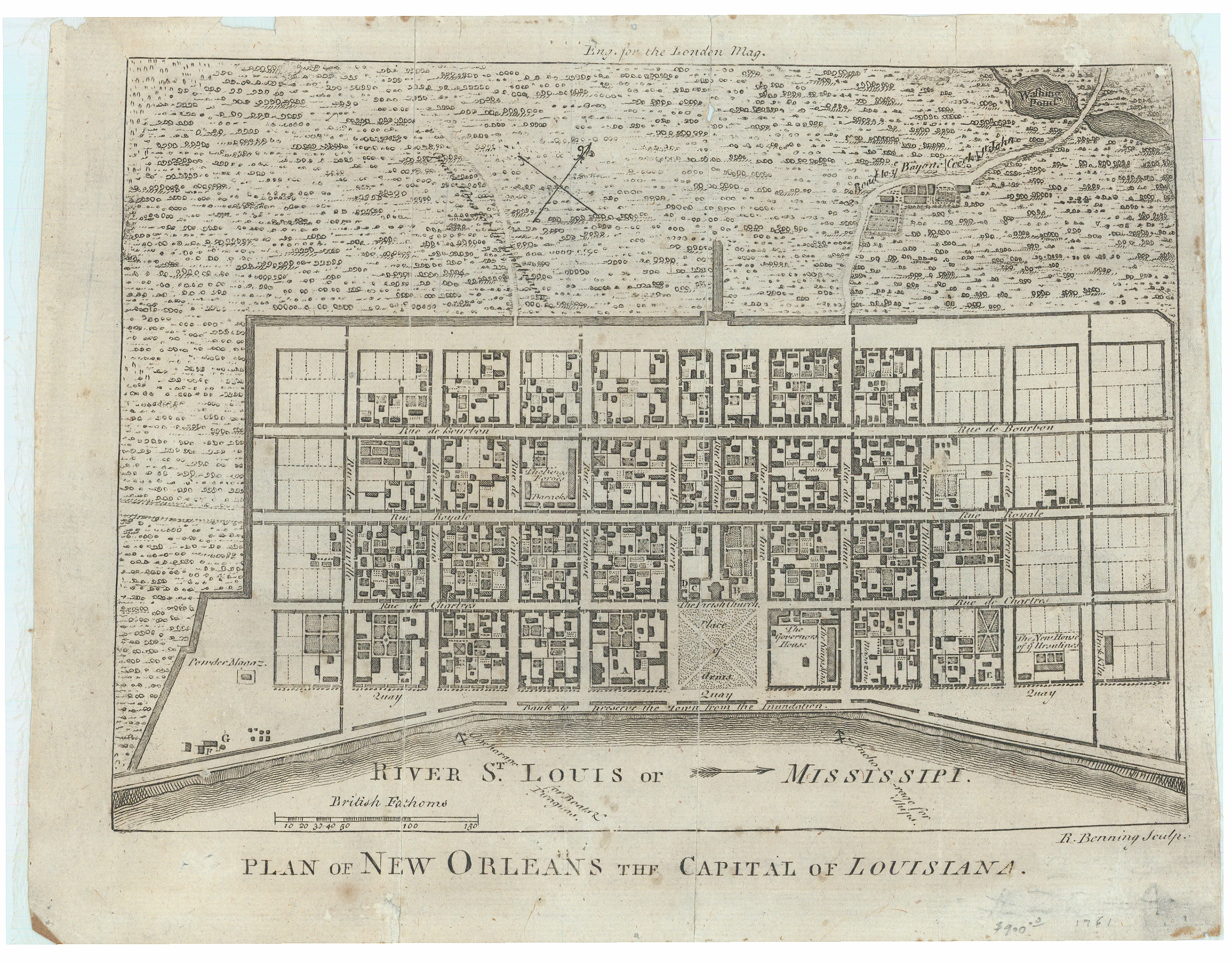
Charming early English plan detailing colonial New Orleans during French rule. Engraved for the London Magazine, April, 1761. Oriented to the northwest at top, scale in British Fathoms. Shows
Bourbon Street, houses, gardens, the Parish Church, municipal buildings, barracks, a powder magazine, a brick kiln, and the New House of ye Ursalines (Ursuline Academy), among its many details. With two roads leading into the city form the north, one indicating a Guard House for the Inhabitants. Based on a manuscript map by Le Blond de la Tour that formed the basis of most plans of New Orleans throughout the 18th century. This is one of the earliest available plans printed in English; the first being Thomas Jefferys' plan of 1759.
Condition
Age toned, early silking to verso, a few tiny holes in image, minor loss top center, paper wavy. Old folds, scattered foxing.
References: Sellers and Van Ee #1679.
- Title: Plan of New Orleans the Capital of Louisiana
- Author: Robert Benning
- Date: 1761
- Medium: Copperplate engraving
- Condition: See description
- Inches: 9.1 x 6.6 [Image]
- Centimeters: 23.11 x 16.76 [Image]
- Product ID: 308090
The Second English Map of Colonial New Orleans
Charming early English plan detailing colonial New Orleans during French rule. Engraved for the London Magazine, April, 1761. Oriented to the northwest at top, scale in British Fathoms. Shows
Bourbon Street, houses, gardens, the Parish Church, municipal buildings, barracks, a powder magazine, a brick kiln, and the New House of ye Ursalines (Ursuline Academy), among its many details. With two roads leading into the city form the north, one indicating a Guard House for the Inhabitants. Based on a manuscript map by Le Blond de la Tour that formed the basis of most plans of New Orleans throughout the 18th century. This is one of the earliest available plans printed in English; the first being Thomas Jefferys' plan of 1759.
Condition
Age toned, early silking to verso, a few tiny holes in image, minor loss top center, paper wavy. Old folds, scattered foxing.
References: Sellers and Van Ee #1679.
Original: $750.00
-65%$750.00
$262.50Description
- Title: Plan of New Orleans the Capital of Louisiana
- Author: Robert Benning
- Date: 1761
- Medium: Copperplate engraving
- Condition: See description
- Inches: 9.1 x 6.6 [Image]
- Centimeters: 23.11 x 16.76 [Image]
- Product ID: 308090
The Second English Map of Colonial New Orleans
Charming early English plan detailing colonial New Orleans during French rule. Engraved for the London Magazine, April, 1761. Oriented to the northwest at top, scale in British Fathoms. Shows
Bourbon Street, houses, gardens, the Parish Church, municipal buildings, barracks, a powder magazine, a brick kiln, and the New House of ye Ursalines (Ursuline Academy), among its many details. With two roads leading into the city form the north, one indicating a Guard House for the Inhabitants. Based on a manuscript map by Le Blond de la Tour that formed the basis of most plans of New Orleans throughout the 18th century. This is one of the earliest available plans printed in English; the first being Thomas Jefferys' plan of 1759.
Condition
Age toned, early silking to verso, a few tiny holes in image, minor loss top center, paper wavy. Old folds, scattered foxing.
References: Sellers and Van Ee #1679.