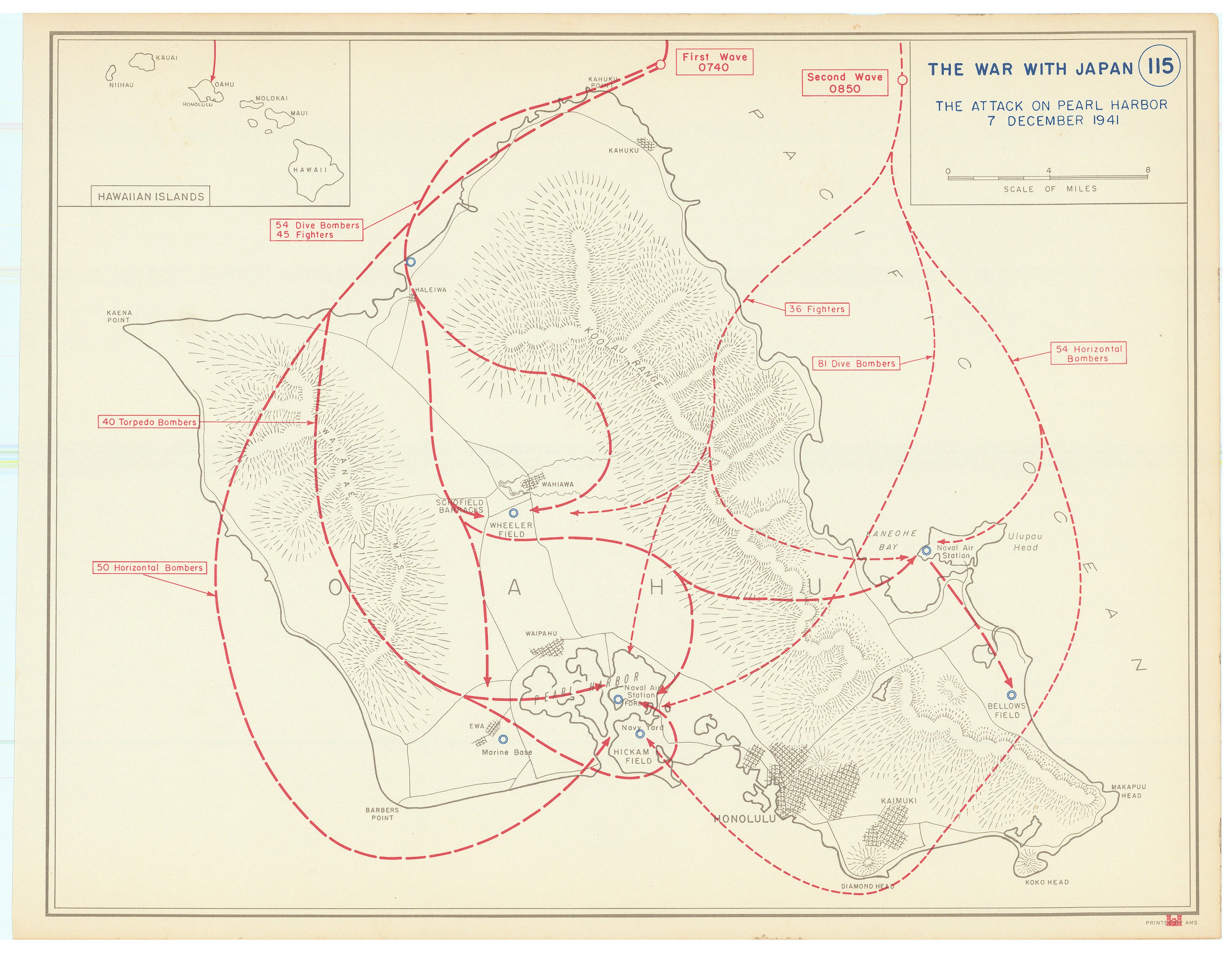
The attack on Pearl Harbor 7 December 1941: United States Military Academy, 1956
- Title: THE ATTACK ON PEARL HARBOR 7 DECEMBER 1941
- Author: United States Military Academy
- Date/Location: 1956, West Point, New York
- Condition: See description
- Inches: 10 x 13 [Image]
- Centimeters: 25.4 x 33.02 [Image]
- Product ID: 308359
…DECEMBER 7, 1941, A DATE WHICH WILL LIVE IN INFAMY…
General map of Oahu showing the route of the Japanese aerial attack on the United States Navy’s Pacific Fleet at Pearl Harbor. In the aftermath of the attack the United States declared war on Japan. The timing, routes, number of planes, and composition of the two waves are captured in red. Targets are indicated with names and blue circles. An inset map shows the orientation of the Hawaiian Islands. Targets include Wheeler Field,
On December 8, 1941, the day after the attack, President Franklin D. Roosevelt delivered his "Day of Infamy" speech to Congress, after which Congress swiftly passed a declaration of war against Japan. The resolution passed the Senate unanimously (82–0) and the House with only one dissenting vote (388–1), and Roosevelt signed it into law that same day. This action formally brought the United States into World War II.
Reference
United States Department of Defense website, accessed 22 May 2025; https://www.defense.gov
Condition
Mild age toning, else fine.
- Title: THE ATTACK ON PEARL HARBOR 7 DECEMBER 1941
- Author: United States Military Academy
- Date/Location: 1956, West Point, New York
- Condition: See description
- Inches: 10 x 13 [Image]
- Centimeters: 25.4 x 33.02 [Image]
- Product ID: 308359
…DECEMBER 7, 1941, A DATE WHICH WILL LIVE IN INFAMY…
General map of Oahu showing the route of the Japanese aerial attack on the United States Navy’s Pacific Fleet at Pearl Harbor. In the aftermath of the attack the United States declared war on Japan. The timing, routes, number of planes, and composition of the two waves are captured in red. Targets are indicated with names and blue circles. An inset map shows the orientation of the Hawaiian Islands. Targets include Wheeler Field,
On December 8, 1941, the day after the attack, President Franklin D. Roosevelt delivered his "Day of Infamy" speech to Congress, after which Congress swiftly passed a declaration of war against Japan. The resolution passed the Senate unanimously (82–0) and the House with only one dissenting vote (388–1), and Roosevelt signed it into law that same day. This action formally brought the United States into World War II.
Reference
United States Department of Defense website, accessed 22 May 2025; https://www.defense.gov
Condition
Mild age toning, else fine.
Description
- Title: THE ATTACK ON PEARL HARBOR 7 DECEMBER 1941
- Author: United States Military Academy
- Date/Location: 1956, West Point, New York
- Condition: See description
- Inches: 10 x 13 [Image]
- Centimeters: 25.4 x 33.02 [Image]
- Product ID: 308359
…DECEMBER 7, 1941, A DATE WHICH WILL LIVE IN INFAMY…
General map of Oahu showing the route of the Japanese aerial attack on the United States Navy’s Pacific Fleet at Pearl Harbor. In the aftermath of the attack the United States declared war on Japan. The timing, routes, number of planes, and composition of the two waves are captured in red. Targets are indicated with names and blue circles. An inset map shows the orientation of the Hawaiian Islands. Targets include Wheeler Field,
On December 8, 1941, the day after the attack, President Franklin D. Roosevelt delivered his "Day of Infamy" speech to Congress, after which Congress swiftly passed a declaration of war against Japan. The resolution passed the Senate unanimously (82–0) and the House with only one dissenting vote (388–1), and Roosevelt signed it into law that same day. This action formally brought the United States into World War II.
Reference
United States Department of Defense website, accessed 22 May 2025; https://www.defense.gov
Condition
Mild age toning, else fine.