De Cust van Westindien: Roggeveen and Robijn 1680
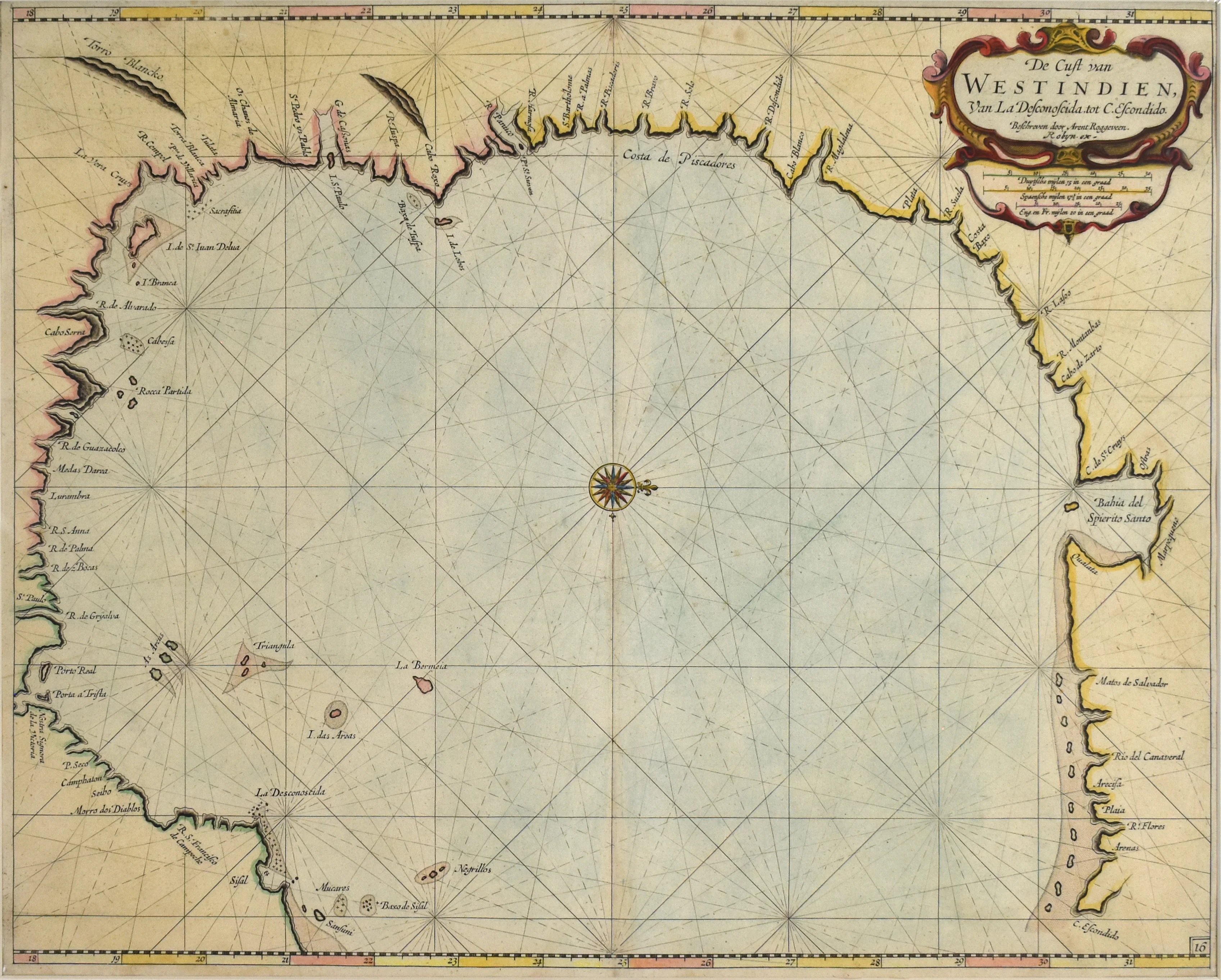
- Title: De Cust van Westindien
- Author: Arent Roggeveen and Jacob Robijn
- Date: 1680
- Medium: Hand-colored copperplate engraving
- Condition: Very Good - age toning, light foxing and surface dirt, issued center fold, minor creasing in margins
- Inches: 20 1/2 x 16 1/2 [Image]
- Centimeters: 52 x 41 [Image]
- Product ID: 233093
"The Coast of the West Indies"
This piece was published as a part of Arent Roggeveen's Het Brandende Veen "The Burning Fern" (referring to the peat bonfires often lit along coastlines to guide ships), an extremely rare maritime atlas and the first of its kind to focus solely on the Americas. This map in particular was the first Dutch-made chart to show the Gulf Coast; in fact, at the time of its publication it stood as the most detailed map ever produced of the region. Following Roggeveen's death in 1679, Amsterdam colorist, engraver, and printer Jacob Robijn (1649 - c. 1707) bought the plates of Het Brandende Veen, publishing the work the following year.
Born outside of Rotterdam, Roggeveen (1628 - 1679) moved in 1658 to Middleburg, the seat of both the Dutch East and West India Companies. He worked for both companies, teaching the art of navigation and helping to maintain their collections of hydrographic manuscripts and charts, some of which included Spanish portolans (nautical charts) of the West Indies. In the mid-1660s, assisted by his access to these collections, he became the first Dutch cartographer to publish a set of large scale navigational charts of the North American coastline and West Indies. Later, he would publish similar charts detailing the coast of West Africa. Many of Roggeveen's maps are based upon the earlier work of Hessel Gerritsz (1581 - 1632) and Joan Vingboons (1616 - 1670), both cartographers for the Dutch East and West India Companies; however, Roggeveen was the first to show the whole coastline of both North America and the Caribbean.
- Title: De Cust van Westindien
- Author: Arent Roggeveen and Jacob Robijn
- Date: 1680
- Medium: Hand-colored copperplate engraving
- Condition: Very Good - age toning, light foxing and surface dirt, issued center fold, minor creasing in margins
- Inches: 20 1/2 x 16 1/2 [Image]
- Centimeters: 52 x 41 [Image]
- Product ID: 233093
"The Coast of the West Indies"
This piece was published as a part of Arent Roggeveen's Het Brandende Veen "The Burning Fern" (referring to the peat bonfires often lit along coastlines to guide ships), an extremely rare maritime atlas and the first of its kind to focus solely on the Americas. This map in particular was the first Dutch-made chart to show the Gulf Coast; in fact, at the time of its publication it stood as the most detailed map ever produced of the region. Following Roggeveen's death in 1679, Amsterdam colorist, engraver, and printer Jacob Robijn (1649 - c. 1707) bought the plates of Het Brandende Veen, publishing the work the following year.
Born outside of Rotterdam, Roggeveen (1628 - 1679) moved in 1658 to Middleburg, the seat of both the Dutch East and West India Companies. He worked for both companies, teaching the art of navigation and helping to maintain their collections of hydrographic manuscripts and charts, some of which included Spanish portolans (nautical charts) of the West Indies. In the mid-1660s, assisted by his access to these collections, he became the first Dutch cartographer to publish a set of large scale navigational charts of the North American coastline and West Indies. Later, he would publish similar charts detailing the coast of West Africa. Many of Roggeveen's maps are based upon the earlier work of Hessel Gerritsz (1581 - 1632) and Joan Vingboons (1616 - 1670), both cartographers for the Dutch East and West India Companies; however, Roggeveen was the first to show the whole coastline of both North America and the Caribbean.
Description
- Title: De Cust van Westindien
- Author: Arent Roggeveen and Jacob Robijn
- Date: 1680
- Medium: Hand-colored copperplate engraving
- Condition: Very Good - age toning, light foxing and surface dirt, issued center fold, minor creasing in margins
- Inches: 20 1/2 x 16 1/2 [Image]
- Centimeters: 52 x 41 [Image]
- Product ID: 233093
"The Coast of the West Indies"
This piece was published as a part of Arent Roggeveen's Het Brandende Veen "The Burning Fern" (referring to the peat bonfires often lit along coastlines to guide ships), an extremely rare maritime atlas and the first of its kind to focus solely on the Americas. This map in particular was the first Dutch-made chart to show the Gulf Coast; in fact, at the time of its publication it stood as the most detailed map ever produced of the region. Following Roggeveen's death in 1679, Amsterdam colorist, engraver, and printer Jacob Robijn (1649 - c. 1707) bought the plates of Het Brandende Veen, publishing the work the following year.
Born outside of Rotterdam, Roggeveen (1628 - 1679) moved in 1658 to Middleburg, the seat of both the Dutch East and West India Companies. He worked for both companies, teaching the art of navigation and helping to maintain their collections of hydrographic manuscripts and charts, some of which included Spanish portolans (nautical charts) of the West Indies. In the mid-1660s, assisted by his access to these collections, he became the first Dutch cartographer to publish a set of large scale navigational charts of the North American coastline and West Indies. Later, he would publish similar charts detailing the coast of West Africa. Many of Roggeveen's maps are based upon the earlier work of Hessel Gerritsz (1581 - 1632) and Joan Vingboons (1616 - 1670), both cartographers for the Dutch East and West India Companies; however, Roggeveen was the first to show the whole coastline of both North America and the Caribbean.