La Parte Occidentale dell' Antico, e Nuovo Messico: Cassini 1798
- Title: La Parte Occidentale dell' Antico, e Nuovo Messico
- Author: Giovanni Maria Cassini
- Date: 1798
- Medium: Hand-colored copperplate engraving
- Condition: Very Good - age toning, issued center fold, creasing, surface dirt, scuffing
- Inches: 17 1/2 x 23 3/4 [Paper]
- Centimeters: 44.45 x 60.33 [Paper]
- Product ID: 319036
La Parte Occidentale dell' Antico, e Nuovo Messico con la Florida e la Bassa Luigina, Delineata sulle ultime Osservazioni. Roma. Presso la Calcografia Camerale 1798.
"The Western Part of Ancient, and New Mexico with Florida and Lower Louisiana, Outlined on the Latest Observations. Rome. At the Chamber of Chalcography 1798."
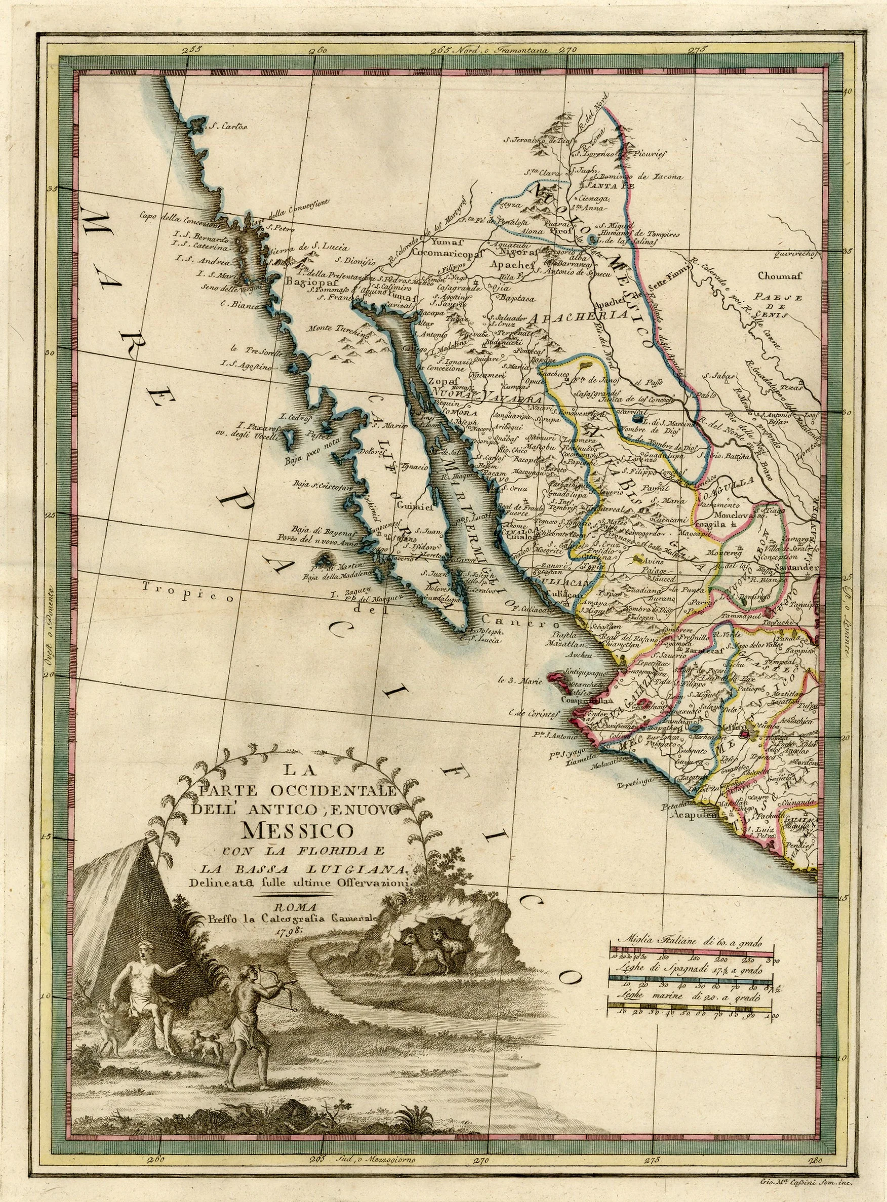
Map of western Mexico by Italian cartographer Giovanni Maria Cassini. Shows the territory of New Mexico and the present-day Mexican states of Baja California, Baja California-Sur, Sonora, Chihuahua, Sinaloa, and Durango. Labels the city of Santa Fe, and marks the Gulf of California as 'Mar Vermiglio' (the Red Sea). Features a large decorative title cartouche showing a hunting scene.
- Title: La Parte Occidentale dell' Antico, e Nuovo Messico
- Author: Giovanni Maria Cassini
- Date: 1798
- Medium: Hand-colored copperplate engraving
- Condition: Very Good - age toning, issued center fold, creasing, surface dirt, scuffing
- Inches: 17 1/2 x 23 3/4 [Paper]
- Centimeters: 44.45 x 60.33 [Paper]
- Product ID: 319036
La Parte Occidentale dell' Antico, e Nuovo Messico con la Florida e la Bassa Luigina, Delineata sulle ultime Osservazioni. Roma. Presso la Calcografia Camerale 1798.
"The Western Part of Ancient, and New Mexico with Florida and Lower Louisiana, Outlined on the Latest Observations. Rome. At the Chamber of Chalcography 1798."
Map of western Mexico by Italian cartographer Giovanni Maria Cassini. Shows the territory of New Mexico and the present-day Mexican states of Baja California, Baja California-Sur, Sonora, Chihuahua, Sinaloa, and Durango. Labels the city of Santa Fe, and marks the Gulf of California as 'Mar Vermiglio' (the Red Sea). Features a large decorative title cartouche showing a hunting scene.
Description
- Title: La Parte Occidentale dell' Antico, e Nuovo Messico
- Author: Giovanni Maria Cassini
- Date: 1798
- Medium: Hand-colored copperplate engraving
- Condition: Very Good - age toning, issued center fold, creasing, surface dirt, scuffing
- Inches: 17 1/2 x 23 3/4 [Paper]
- Centimeters: 44.45 x 60.33 [Paper]
- Product ID: 319036
La Parte Occidentale dell' Antico, e Nuovo Messico con la Florida e la Bassa Luigina, Delineata sulle ultime Osservazioni. Roma. Presso la Calcografia Camerale 1798.
"The Western Part of Ancient, and New Mexico with Florida and Lower Louisiana, Outlined on the Latest Observations. Rome. At the Chamber of Chalcography 1798."
Map of western Mexico by Italian cartographer Giovanni Maria Cassini. Shows the territory of New Mexico and the present-day Mexican states of Baja California, Baja California-Sur, Sonora, Chihuahua, Sinaloa, and Durango. Labels the city of Santa Fe, and marks the Gulf of California as 'Mar Vermiglio' (the Red Sea). Features a large decorative title cartouche showing a hunting scene.