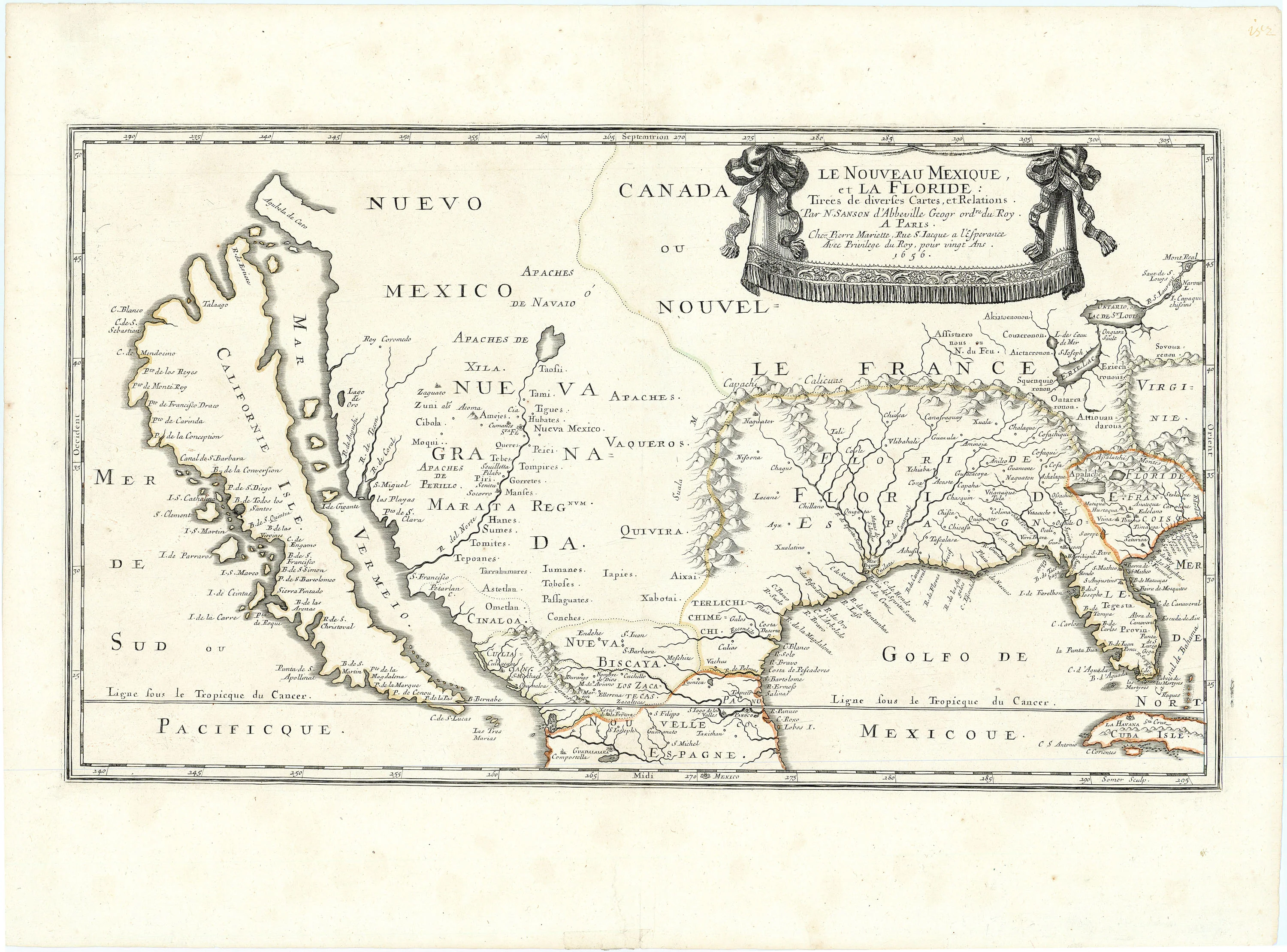
Le Nouveau Mexique, et la Floride: Sanson 1656
- Title: Le Nouveau Mexique, et la Floride
- Author: Nicolas Sanson
- Date: 1656
- Medium: Hand-colored copperplate engraving
-
Condition: Very Good Plus - wide margined example, well inked. Contemporary outline color. Old mounting hinges on verso, expertly repaired tear at center left bottom, not entering image. Excellent example.
- Inches: 12 5/8 x 21 3/4 [Image]
- Centimeters: 32.07 x 55.25 [Image]
- Product ID: 315100
Le Nouveau Mexique, et la Floride: Tirées de diverses Cartes, et Relations. Par N. Sanson d'Abbeville Geogr ordre du Roy. A Paris. Chez Pierre Mariette, Rue S. Iacque a l'Esperance Avec Privilege du Roy, pour vingt Ans. 1656.
"New Mexico, and Florida: Taken from Various Maps and Relations. By N. Sanson d'Abbeville Geographer Ordinaire of the King. In Paris, House of Pierre Mariette, Rue S. Iacque a l'Esperance With Privilege of the King, for twenty Years. 1656."
First state of one of the most important maps ever published of the American West, and the model for California for a half-century. Sanson’s 1656 map of New Mexico and Florida, the first significant map printed in an atlas to depict the present-day American southwest, stands as a groundbreaking achievement of great importance to the Trans-Mississippi region. It represents the best information available to seventeenth-century Europeans about the greater Texas region, demonstrating how little was known about the area prior to Spanish mission expansions within the Southwest. Sanson locates a few Indian tribes in the Texas region, but the area's river system (including the Mississippi) remains clearly unknown and undescribed.
For many years, this map served as a prototype for California’s depiction as an island; though Sanson popularized this outline, his prestige and credibility contributing to its longevity, its source was Luke Foxe’s map of the Arctic regions of North America (pub. 1635). Sanson contributed a number of new place names to locations within the New Mexico region, a vast area ranging from the Pacific Ocean to the west, the Florida territory to the east, and Canada to the north. He also perpetuated several traditional errors, such as the placement of Cibola and Quivira, and he contributed some new ones such as showing the Rio Del Norte flowing into the Gulf of California. Despite its shortcomings, this map remains an extraordinary document of the cultural and geographical resources available at the time to learned Europeans.
Born in 1600, Sanson exhibited in his earliest years a special aptitude towards and interest in geography. His profound skills and tireless work ethic established him as a world leader in cartographic production, earning him the title of Royal Geographer to King Louis XIII by the age of forty. He and his disciples rejected the Dutch tendency towards heavy ornamentation in the drawing of maps; instead, they emphasized only verifiable information. As a result, their maps accurately reflect the extent of available information about exploration and discovery. The French school of cartography, with Sanson as its de facto leader, dominated the global map trade for over 100 years.
- Title: Le Nouveau Mexique, et la Floride
- Author: Nicolas Sanson
- Date: 1656
- Medium: Hand-colored copperplate engraving
-
Condition: Very Good Plus - wide margined example, well inked. Contemporary outline color. Old mounting hinges on verso, expertly repaired tear at center left bottom, not entering image. Excellent example.
- Inches: 12 5/8 x 21 3/4 [Image]
- Centimeters: 32.07 x 55.25 [Image]
- Product ID: 315100
Le Nouveau Mexique, et la Floride: Tirées de diverses Cartes, et Relations. Par N. Sanson d'Abbeville Geogr ordre du Roy. A Paris. Chez Pierre Mariette, Rue S. Iacque a l'Esperance Avec Privilege du Roy, pour vingt Ans. 1656.
"New Mexico, and Florida: Taken from Various Maps and Relations. By N. Sanson d'Abbeville Geographer Ordinaire of the King. In Paris, House of Pierre Mariette, Rue S. Iacque a l'Esperance With Privilege of the King, for twenty Years. 1656."
First state of one of the most important maps ever published of the American West, and the model for California for a half-century. Sanson’s 1656 map of New Mexico and Florida, the first significant map printed in an atlas to depict the present-day American southwest, stands as a groundbreaking achievement of great importance to the Trans-Mississippi region. It represents the best information available to seventeenth-century Europeans about the greater Texas region, demonstrating how little was known about the area prior to Spanish mission expansions within the Southwest. Sanson locates a few Indian tribes in the Texas region, but the area's river system (including the Mississippi) remains clearly unknown and undescribed.
For many years, this map served as a prototype for California’s depiction as an island; though Sanson popularized this outline, his prestige and credibility contributing to its longevity, its source was Luke Foxe’s map of the Arctic regions of North America (pub. 1635). Sanson contributed a number of new place names to locations within the New Mexico region, a vast area ranging from the Pacific Ocean to the west, the Florida territory to the east, and Canada to the north. He also perpetuated several traditional errors, such as the placement of Cibola and Quivira, and he contributed some new ones such as showing the Rio Del Norte flowing into the Gulf of California. Despite its shortcomings, this map remains an extraordinary document of the cultural and geographical resources available at the time to learned Europeans.
Born in 1600, Sanson exhibited in his earliest years a special aptitude towards and interest in geography. His profound skills and tireless work ethic established him as a world leader in cartographic production, earning him the title of Royal Geographer to King Louis XIII by the age of forty. He and his disciples rejected the Dutch tendency towards heavy ornamentation in the drawing of maps; instead, they emphasized only verifiable information. As a result, their maps accurately reflect the extent of available information about exploration and discovery. The French school of cartography, with Sanson as its de facto leader, dominated the global map trade for over 100 years.
Description
- Title: Le Nouveau Mexique, et la Floride
- Author: Nicolas Sanson
- Date: 1656
- Medium: Hand-colored copperplate engraving
-
Condition: Very Good Plus - wide margined example, well inked. Contemporary outline color. Old mounting hinges on verso, expertly repaired tear at center left bottom, not entering image. Excellent example.
- Inches: 12 5/8 x 21 3/4 [Image]
- Centimeters: 32.07 x 55.25 [Image]
- Product ID: 315100
Le Nouveau Mexique, et la Floride: Tirées de diverses Cartes, et Relations. Par N. Sanson d'Abbeville Geogr ordre du Roy. A Paris. Chez Pierre Mariette, Rue S. Iacque a l'Esperance Avec Privilege du Roy, pour vingt Ans. 1656.
"New Mexico, and Florida: Taken from Various Maps and Relations. By N. Sanson d'Abbeville Geographer Ordinaire of the King. In Paris, House of Pierre Mariette, Rue S. Iacque a l'Esperance With Privilege of the King, for twenty Years. 1656."
First state of one of the most important maps ever published of the American West, and the model for California for a half-century. Sanson’s 1656 map of New Mexico and Florida, the first significant map printed in an atlas to depict the present-day American southwest, stands as a groundbreaking achievement of great importance to the Trans-Mississippi region. It represents the best information available to seventeenth-century Europeans about the greater Texas region, demonstrating how little was known about the area prior to Spanish mission expansions within the Southwest. Sanson locates a few Indian tribes in the Texas region, but the area's river system (including the Mississippi) remains clearly unknown and undescribed.
For many years, this map served as a prototype for California’s depiction as an island; though Sanson popularized this outline, his prestige and credibility contributing to its longevity, its source was Luke Foxe’s map of the Arctic regions of North America (pub. 1635). Sanson contributed a number of new place names to locations within the New Mexico region, a vast area ranging from the Pacific Ocean to the west, the Florida territory to the east, and Canada to the north. He also perpetuated several traditional errors, such as the placement of Cibola and Quivira, and he contributed some new ones such as showing the Rio Del Norte flowing into the Gulf of California. Despite its shortcomings, this map remains an extraordinary document of the cultural and geographical resources available at the time to learned Europeans.
Born in 1600, Sanson exhibited in his earliest years a special aptitude towards and interest in geography. His profound skills and tireless work ethic established him as a world leader in cartographic production, earning him the title of Royal Geographer to King Louis XIII by the age of forty. He and his disciples rejected the Dutch tendency towards heavy ornamentation in the drawing of maps; instead, they emphasized only verifiable information. As a result, their maps accurately reflect the extent of available information about exploration and discovery. The French school of cartography, with Sanson as its de facto leader, dominated the global map trade for over 100 years.