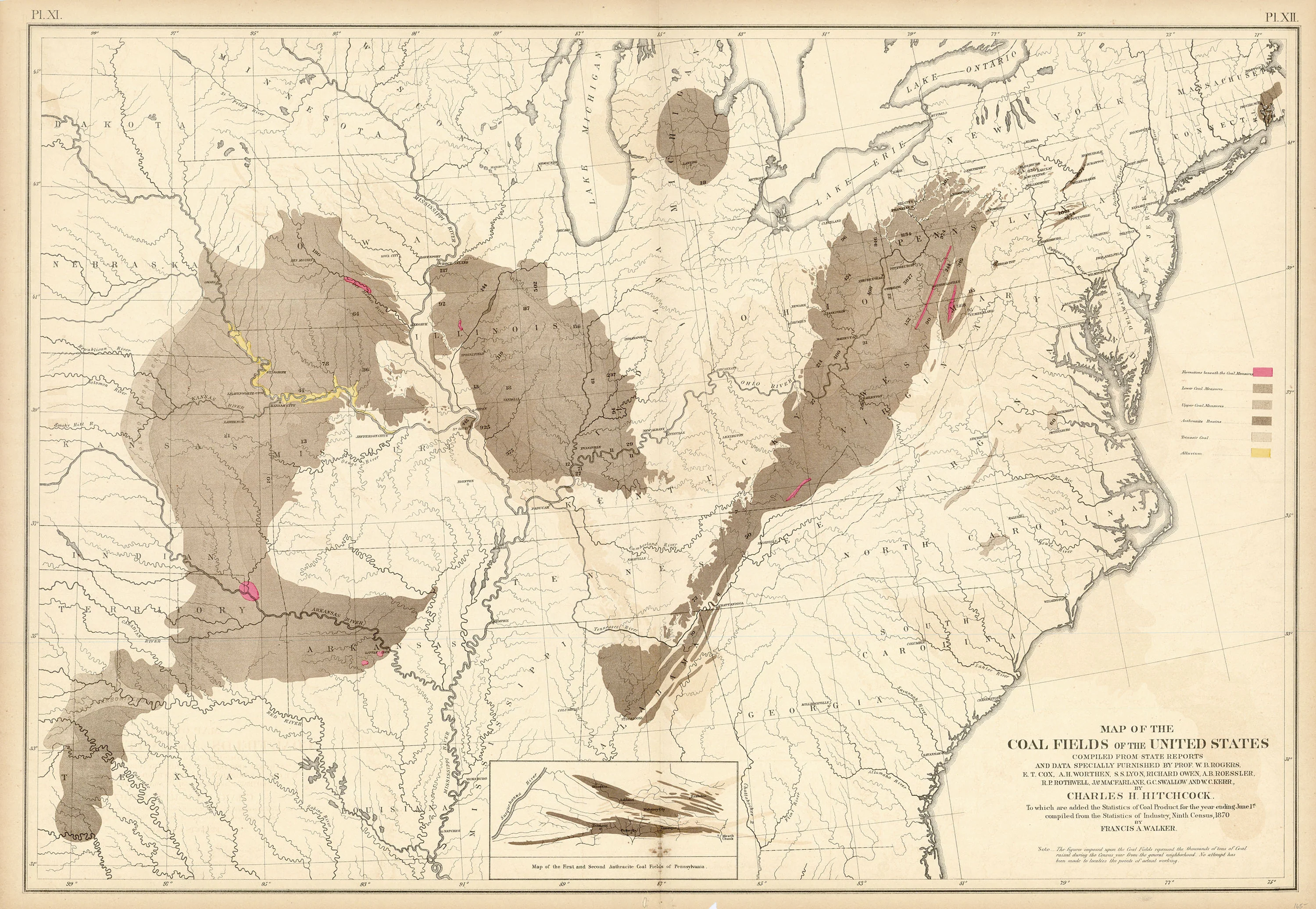
Map of the Coal Fields of the United States: Walker 1874
- Title: Map of the Coal Fields of the United States
- Author: Francis A. Walker
- Date: 1874
- Medium: Chromolithograph
- Condition: Very Good - age toning, paper loss in bottom margin and corners, foxing and discoloration, issued center fold
- Inches: 31 1/4 x 21 3/4 [Paper]
- Centimeters: 79.38 x 55.25 [Paper]
- Product ID: 316077
Map of the Coal Fields of the United States Compiled from State Reports and Data Specially Furnished by Prof. W. B. Rogers, E. T. Cox, A. H. Worthen, S. S. Lyon, Richard Owen, A. B. Roessler, R. P. Rothwell, Jas. Macfarlane, G. C. Swallow and W. C Kerr, by Charles H. Hitchcock. To which are added the Statistics of Coal Product for the year ending June 1st. Compiled from the Statistics of Industry, Ninth Census 1870, by Francis A. Walker.
Map showing the coal fields of the United States with an inset map titled 'Map of the First and Second Anthracite Coal Fields of Pennsylvania,' chromolithographed by Julius Bien. Colored legend explains the different varieties of coal deposits. Map includes Georgia, North and South Carolina, Virginia, Tennessee, Kentucky, Illinois, Kansas, Nebraska, Dakota, Minnesota, Wisconsin, Arkansas, Mississippi, Alabama, Ohio, New York, Pennsylvania, Indiana, Iowa, Maryland, New Jersey, Delaware, Massachusetts, Connecticut, Texas, and Indian Territory.
Bien (1826-1909) was born in Naumburg, Germany to a Jewish family. Best known for his scientific maps of the United States, Bien gained a reputation as a master lithographer and the foremost American scientific cartographer of his day. Coming of age as a young German in the mid-1840s, Bien studied art at both the Kunsthochschule Kassel as well as the Städel Institute in Frankfurt until the Revolutions of 1848 disrupted his burgeoning career. As liberal uprisings spread across Europe, Bien fought for causes such as German unity, freedom of the press, and freedom of assembly, as did many others of Jewish descent. After this revolutionary wave failed to take hold, Bien and other liberals went into exile; he fled to New York in 1849, where he established a small lithographic business and soon made a name for himself as a printer of exceptional skill.
Over the course of his career, Bien won awards from exhibitions around the world and completed numerous major contracts with the United States government. To list only some of his prolific accomplishments, Bien produced surveys of the western U.S. for the Pacific Railroad, created maps documenting the Civil War, and published charts and graphics to accompany the Federal Census report. Later in his career, he also produced various atlases of remarkable quality.
In the late 1850s, John Woodhouse Audubon (son of John J. Audubon) recruited Bien for his chromolithographic expertise, seeking to transfer his father’s famous Birds of America onto lithographic stone from their original copper plates. Chromolithographic printing would allow Audubon to reproduce the images at nearly half of their original cost, bypassing the labor and expense associated with hand-coloring. However, the onset of the Civil War compounded with questionable business dealings on the part of Audubon’s associates ensured the project’s failure. Nevertheless, 150 images were printed from 105 plates, and Bien’s reproductions now number among the rarest and most in-demand of all Audubon prints. It is estimated that only 50-100 Bien Audubons remain extant.
Bien also undertook prominent leadership roles over the course of his life, serving as founding president of the National Lithographers' Association from 1886-96. From 1854-57 and again from 1868-1900, he served as president of B’nai B’rith, a Jewish service organization dedicated to philanthropy and community-building; he is credited in large part with growing the organization’s international presence.
- Title: Map of the Coal Fields of the United States
- Author: Francis A. Walker
- Date: 1874
- Medium: Chromolithograph
- Condition: Very Good - age toning, paper loss in bottom margin and corners, foxing and discoloration, issued center fold
- Inches: 31 1/4 x 21 3/4 [Paper]
- Centimeters: 79.38 x 55.25 [Paper]
- Product ID: 316077
Map of the Coal Fields of the United States Compiled from State Reports and Data Specially Furnished by Prof. W. B. Rogers, E. T. Cox, A. H. Worthen, S. S. Lyon, Richard Owen, A. B. Roessler, R. P. Rothwell, Jas. Macfarlane, G. C. Swallow and W. C Kerr, by Charles H. Hitchcock. To which are added the Statistics of Coal Product for the year ending June 1st. Compiled from the Statistics of Industry, Ninth Census 1870, by Francis A. Walker.
Map showing the coal fields of the United States with an inset map titled 'Map of the First and Second Anthracite Coal Fields of Pennsylvania,' chromolithographed by Julius Bien. Colored legend explains the different varieties of coal deposits. Map includes Georgia, North and South Carolina, Virginia, Tennessee, Kentucky, Illinois, Kansas, Nebraska, Dakota, Minnesota, Wisconsin, Arkansas, Mississippi, Alabama, Ohio, New York, Pennsylvania, Indiana, Iowa, Maryland, New Jersey, Delaware, Massachusetts, Connecticut, Texas, and Indian Territory.
Bien (1826-1909) was born in Naumburg, Germany to a Jewish family. Best known for his scientific maps of the United States, Bien gained a reputation as a master lithographer and the foremost American scientific cartographer of his day. Coming of age as a young German in the mid-1840s, Bien studied art at both the Kunsthochschule Kassel as well as the Städel Institute in Frankfurt until the Revolutions of 1848 disrupted his burgeoning career. As liberal uprisings spread across Europe, Bien fought for causes such as German unity, freedom of the press, and freedom of assembly, as did many others of Jewish descent. After this revolutionary wave failed to take hold, Bien and other liberals went into exile; he fled to New York in 1849, where he established a small lithographic business and soon made a name for himself as a printer of exceptional skill.
Over the course of his career, Bien won awards from exhibitions around the world and completed numerous major contracts with the United States government. To list only some of his prolific accomplishments, Bien produced surveys of the western U.S. for the Pacific Railroad, created maps documenting the Civil War, and published charts and graphics to accompany the Federal Census report. Later in his career, he also produced various atlases of remarkable quality.
In the late 1850s, John Woodhouse Audubon (son of John J. Audubon) recruited Bien for his chromolithographic expertise, seeking to transfer his father’s famous Birds of America onto lithographic stone from their original copper plates. Chromolithographic printing would allow Audubon to reproduce the images at nearly half of their original cost, bypassing the labor and expense associated with hand-coloring. However, the onset of the Civil War compounded with questionable business dealings on the part of Audubon’s associates ensured the project’s failure. Nevertheless, 150 images were printed from 105 plates, and Bien’s reproductions now number among the rarest and most in-demand of all Audubon prints. It is estimated that only 50-100 Bien Audubons remain extant.
Bien also undertook prominent leadership roles over the course of his life, serving as founding president of the National Lithographers' Association from 1886-96. From 1854-57 and again from 1868-1900, he served as president of B’nai B’rith, a Jewish service organization dedicated to philanthropy and community-building; he is credited in large part with growing the organization’s international presence.
Original: $195.00
-65%$195.00
$68.25Description
- Title: Map of the Coal Fields of the United States
- Author: Francis A. Walker
- Date: 1874
- Medium: Chromolithograph
- Condition: Very Good - age toning, paper loss in bottom margin and corners, foxing and discoloration, issued center fold
- Inches: 31 1/4 x 21 3/4 [Paper]
- Centimeters: 79.38 x 55.25 [Paper]
- Product ID: 316077
Map of the Coal Fields of the United States Compiled from State Reports and Data Specially Furnished by Prof. W. B. Rogers, E. T. Cox, A. H. Worthen, S. S. Lyon, Richard Owen, A. B. Roessler, R. P. Rothwell, Jas. Macfarlane, G. C. Swallow and W. C Kerr, by Charles H. Hitchcock. To which are added the Statistics of Coal Product for the year ending June 1st. Compiled from the Statistics of Industry, Ninth Census 1870, by Francis A. Walker.
Map showing the coal fields of the United States with an inset map titled 'Map of the First and Second Anthracite Coal Fields of Pennsylvania,' chromolithographed by Julius Bien. Colored legend explains the different varieties of coal deposits. Map includes Georgia, North and South Carolina, Virginia, Tennessee, Kentucky, Illinois, Kansas, Nebraska, Dakota, Minnesota, Wisconsin, Arkansas, Mississippi, Alabama, Ohio, New York, Pennsylvania, Indiana, Iowa, Maryland, New Jersey, Delaware, Massachusetts, Connecticut, Texas, and Indian Territory.
Bien (1826-1909) was born in Naumburg, Germany to a Jewish family. Best known for his scientific maps of the United States, Bien gained a reputation as a master lithographer and the foremost American scientific cartographer of his day. Coming of age as a young German in the mid-1840s, Bien studied art at both the Kunsthochschule Kassel as well as the Städel Institute in Frankfurt until the Revolutions of 1848 disrupted his burgeoning career. As liberal uprisings spread across Europe, Bien fought for causes such as German unity, freedom of the press, and freedom of assembly, as did many others of Jewish descent. After this revolutionary wave failed to take hold, Bien and other liberals went into exile; he fled to New York in 1849, where he established a small lithographic business and soon made a name for himself as a printer of exceptional skill.
Over the course of his career, Bien won awards from exhibitions around the world and completed numerous major contracts with the United States government. To list only some of his prolific accomplishments, Bien produced surveys of the western U.S. for the Pacific Railroad, created maps documenting the Civil War, and published charts and graphics to accompany the Federal Census report. Later in his career, he also produced various atlases of remarkable quality.
In the late 1850s, John Woodhouse Audubon (son of John J. Audubon) recruited Bien for his chromolithographic expertise, seeking to transfer his father’s famous Birds of America onto lithographic stone from their original copper plates. Chromolithographic printing would allow Audubon to reproduce the images at nearly half of their original cost, bypassing the labor and expense associated with hand-coloring. However, the onset of the Civil War compounded with questionable business dealings on the part of Audubon’s associates ensured the project’s failure. Nevertheless, 150 images were printed from 105 plates, and Bien’s reproductions now number among the rarest and most in-demand of all Audubon prints. It is estimated that only 50-100 Bien Audubons remain extant.
Bien also undertook prominent leadership roles over the course of his life, serving as founding president of the National Lithographers' Association from 1886-96. From 1854-57 and again from 1868-1900, he served as president of B’nai B’rith, a Jewish service organization dedicated to philanthropy and community-building; he is credited in large part with growing the organization’s international presence.