Geologic Map of Texas: Sellards, 1933
- Title: Geologic Map of Texas
- Author: E. H. Sellards
- Date: 1933
- Condition: Very good, issued folds, minor separation in a few places where folds meet, uniform toning, very minor staining
- Inches: 25 1/2 x 20 1/2 [Image]
- Centimeters: 64.77 x 52.07 [Image]
- Product ID: 308257
The University of Texas
Bureau of Economic Geology
E. H. Sellards, Director
Geologic Map
of
Texas
1933
Part 5 of Volume I of the Geology of Texas
by
E. H. Sellards, W. S. Adkins, and F. B. Plummer
The base and the geologic mapping for this map are adapted from Geologic Map of Texas, preliminary edition, issued by the United States Geological Survey, 1932; compiled between the years 1924 and 1932 by the United States Geological Survey, in cooperation with the Bureau of Economic Geology of The University of Texas, the geologists of Texas, and the oil companies of Texas, from all available published material and from unpublished data furnished by geologists of the United States Geological Survey, the Bureau of Economic Geology, and by consulting geologists.
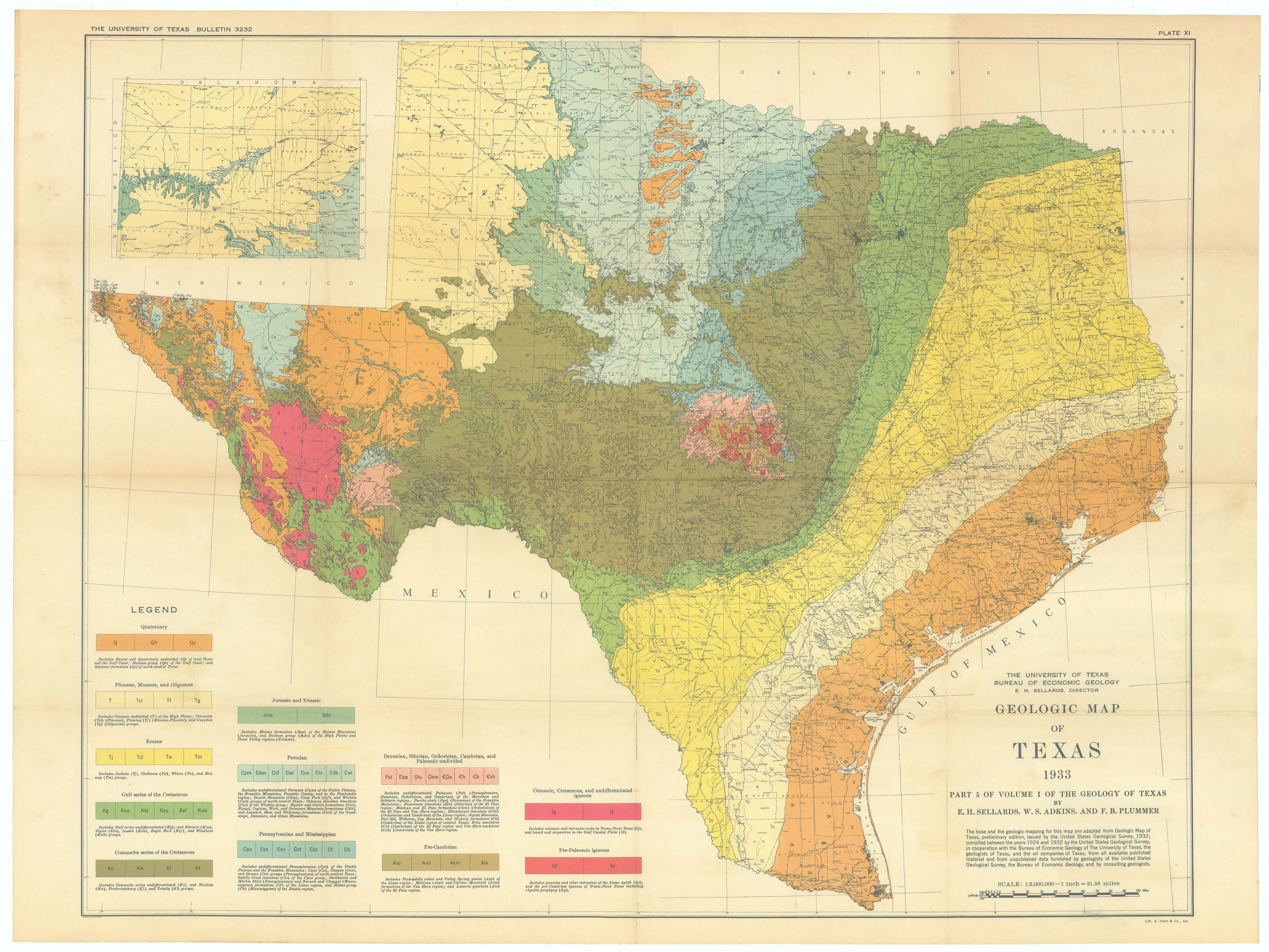
Map of Texas color-coded according to geologic regions with inset map of panhandle in upper left. This map represents a cooperative effort between the Bureau of Economic Geology of the University of Texas at Austin and the United States Geological Survey (USGS). Its economic value represents one of the many significant contributions the University of Texas and its partners have made to the state of Texas. This map identifies the entire spectrum of geologic occurrence in the state, of the utmost importance to the people and economy of Texas.
The Bureau of Economic Geology is the oldest research unit at The University of Texas at Austin, established in 1909. The Bureau is the State Geological Survey of Texas and has been an integral part of the development of the state’s economic success through the years. It remains extremely active today, conducting integrated geoscience research on relevant energy, environmental, and economic issues. Bureau researchers spearhead basic and applied research projects globally in energy resources and economics, coastal and environmental studies, land resources and use, geologic and mineral mapping, hydrogeology, geochemistry, and subsurface nanotechnology.
The Bureau of Economic Geology is the oldest research unit at The University of Texas at Austin, established in 1909. The Bureau is the State Geological Survey of Texas and has been an integral part of the development of the state’s economic success through the years. It remains extremely active today, conducting integrated geoscience research on relevant energy, environmental, and economic issues. Bureau researchers spearhead basic and applied research projects globally in energy resources and economics, coastal and environmental studies, land resources and use, geologic and mineral mapping, hydrogeology, geochemistry, and subsurface nanotechnology.
Created by Congress on March 3, 1879, the USGS was originally dedicated to exploring the geology and mineral potential of western lands. The USGS revolutionized surveying. Before the USGS was formed, most mapping in the United States was done by military expeditions and several independent government surveys. Upon its creation, the USGS established a comprehensive approach to surveying and worked to classify public lands by examining their geological structure, mineral resources, and products. This scientific appraisal of land potential and mineral resources changed the way government approached surveying. It also encouraged conservation, economic expansion, and more efficient development across the nation.
The USGS has been making topographic maps of Texas since the 1880s. The early maps show roads, towns and settlements, and political boundaries, though the physical features are only generalized. Advances in the field of geology enabled scientists to determine the nature of the rocks and minerals that make up the earth and specify how they were formed. Additionally, scientists were better able to identify coal, oil, and gas resources and assess their potential for development. This map represents that modern effort, identifying in detail 102 geologic features such as mineral composition, rock structure, and mineral resources, chronicling the geologic history of the Texas landscape. Beautifully rendered and truly impressive, a lovely map of Texas.
The USGS has been making topographic maps of Texas since the 1880s. The early maps show roads, towns and settlements, and political boundaries, though the physical features are only generalized. Advances in the field of geology enabled scientists to determine the nature of the rocks and minerals that make up the earth and specify how they were formed. Additionally, scientists were better able to identify coal, oil, and gas resources and assess their potential for development. This map represents that modern effort, identifying in detail 102 geologic features such as mineral composition, rock structure, and mineral resources, chronicling the geologic history of the Texas landscape. Beautifully rendered and truly impressive, a lovely map of Texas.
- Title: Geologic Map of Texas
- Author: E. H. Sellards
- Date: 1933
- Condition: Very good, issued folds, minor separation in a few places where folds meet, uniform toning, very minor staining
- Inches: 25 1/2 x 20 1/2 [Image]
- Centimeters: 64.77 x 52.07 [Image]
- Product ID: 308257
The University of Texas
Bureau of Economic Geology
E. H. Sellards, Director
Geologic Map
of
Texas
1933
Part 5 of Volume I of the Geology of Texas
by
E. H. Sellards, W. S. Adkins, and F. B. Plummer
The base and the geologic mapping for this map are adapted from Geologic Map of Texas, preliminary edition, issued by the United States Geological Survey, 1932; compiled between the years 1924 and 1932 by the United States Geological Survey, in cooperation with the Bureau of Economic Geology of The University of Texas, the geologists of Texas, and the oil companies of Texas, from all available published material and from unpublished data furnished by geologists of the United States Geological Survey, the Bureau of Economic Geology, and by consulting geologists.
Map of Texas color-coded according to geologic regions with inset map of panhandle in upper left. This map represents a cooperative effort between the Bureau of Economic Geology of the University of Texas at Austin and the United States Geological Survey (USGS). Its economic value represents one of the many significant contributions the University of Texas and its partners have made to the state of Texas. This map identifies the entire spectrum of geologic occurrence in the state, of the utmost importance to the people and economy of Texas.
The Bureau of Economic Geology is the oldest research unit at The University of Texas at Austin, established in 1909. The Bureau is the State Geological Survey of Texas and has been an integral part of the development of the state’s economic success through the years. It remains extremely active today, conducting integrated geoscience research on relevant energy, environmental, and economic issues. Bureau researchers spearhead basic and applied research projects globally in energy resources and economics, coastal and environmental studies, land resources and use, geologic and mineral mapping, hydrogeology, geochemistry, and subsurface nanotechnology.
The Bureau of Economic Geology is the oldest research unit at The University of Texas at Austin, established in 1909. The Bureau is the State Geological Survey of Texas and has been an integral part of the development of the state’s economic success through the years. It remains extremely active today, conducting integrated geoscience research on relevant energy, environmental, and economic issues. Bureau researchers spearhead basic and applied research projects globally in energy resources and economics, coastal and environmental studies, land resources and use, geologic and mineral mapping, hydrogeology, geochemistry, and subsurface nanotechnology.
Created by Congress on March 3, 1879, the USGS was originally dedicated to exploring the geology and mineral potential of western lands. The USGS revolutionized surveying. Before the USGS was formed, most mapping in the United States was done by military expeditions and several independent government surveys. Upon its creation, the USGS established a comprehensive approach to surveying and worked to classify public lands by examining their geological structure, mineral resources, and products. This scientific appraisal of land potential and mineral resources changed the way government approached surveying. It also encouraged conservation, economic expansion, and more efficient development across the nation.
The USGS has been making topographic maps of Texas since the 1880s. The early maps show roads, towns and settlements, and political boundaries, though the physical features are only generalized. Advances in the field of geology enabled scientists to determine the nature of the rocks and minerals that make up the earth and specify how they were formed. Additionally, scientists were better able to identify coal, oil, and gas resources and assess their potential for development. This map represents that modern effort, identifying in detail 102 geologic features such as mineral composition, rock structure, and mineral resources, chronicling the geologic history of the Texas landscape. Beautifully rendered and truly impressive, a lovely map of Texas.
The USGS has been making topographic maps of Texas since the 1880s. The early maps show roads, towns and settlements, and political boundaries, though the physical features are only generalized. Advances in the field of geology enabled scientists to determine the nature of the rocks and minerals that make up the earth and specify how they were formed. Additionally, scientists were better able to identify coal, oil, and gas resources and assess their potential for development. This map represents that modern effort, identifying in detail 102 geologic features such as mineral composition, rock structure, and mineral resources, chronicling the geologic history of the Texas landscape. Beautifully rendered and truly impressive, a lovely map of Texas.
$2,000.00
Geologic Map of Texas: Sellards, 1933—
$2,000.00
Description
- Title: Geologic Map of Texas
- Author: E. H. Sellards
- Date: 1933
- Condition: Very good, issued folds, minor separation in a few places where folds meet, uniform toning, very minor staining
- Inches: 25 1/2 x 20 1/2 [Image]
- Centimeters: 64.77 x 52.07 [Image]
- Product ID: 308257
The University of Texas
Bureau of Economic Geology
E. H. Sellards, Director
Geologic Map
of
Texas
1933
Part 5 of Volume I of the Geology of Texas
by
E. H. Sellards, W. S. Adkins, and F. B. Plummer
The base and the geologic mapping for this map are adapted from Geologic Map of Texas, preliminary edition, issued by the United States Geological Survey, 1932; compiled between the years 1924 and 1932 by the United States Geological Survey, in cooperation with the Bureau of Economic Geology of The University of Texas, the geologists of Texas, and the oil companies of Texas, from all available published material and from unpublished data furnished by geologists of the United States Geological Survey, the Bureau of Economic Geology, and by consulting geologists.
Map of Texas color-coded according to geologic regions with inset map of panhandle in upper left. This map represents a cooperative effort between the Bureau of Economic Geology of the University of Texas at Austin and the United States Geological Survey (USGS). Its economic value represents one of the many significant contributions the University of Texas and its partners have made to the state of Texas. This map identifies the entire spectrum of geologic occurrence in the state, of the utmost importance to the people and economy of Texas.
The Bureau of Economic Geology is the oldest research unit at The University of Texas at Austin, established in 1909. The Bureau is the State Geological Survey of Texas and has been an integral part of the development of the state’s economic success through the years. It remains extremely active today, conducting integrated geoscience research on relevant energy, environmental, and economic issues. Bureau researchers spearhead basic and applied research projects globally in energy resources and economics, coastal and environmental studies, land resources and use, geologic and mineral mapping, hydrogeology, geochemistry, and subsurface nanotechnology.
The Bureau of Economic Geology is the oldest research unit at The University of Texas at Austin, established in 1909. The Bureau is the State Geological Survey of Texas and has been an integral part of the development of the state’s economic success through the years. It remains extremely active today, conducting integrated geoscience research on relevant energy, environmental, and economic issues. Bureau researchers spearhead basic and applied research projects globally in energy resources and economics, coastal and environmental studies, land resources and use, geologic and mineral mapping, hydrogeology, geochemistry, and subsurface nanotechnology.
Created by Congress on March 3, 1879, the USGS was originally dedicated to exploring the geology and mineral potential of western lands. The USGS revolutionized surveying. Before the USGS was formed, most mapping in the United States was done by military expeditions and several independent government surveys. Upon its creation, the USGS established a comprehensive approach to surveying and worked to classify public lands by examining their geological structure, mineral resources, and products. This scientific appraisal of land potential and mineral resources changed the way government approached surveying. It also encouraged conservation, economic expansion, and more efficient development across the nation.
The USGS has been making topographic maps of Texas since the 1880s. The early maps show roads, towns and settlements, and political boundaries, though the physical features are only generalized. Advances in the field of geology enabled scientists to determine the nature of the rocks and minerals that make up the earth and specify how they were formed. Additionally, scientists were better able to identify coal, oil, and gas resources and assess their potential for development. This map represents that modern effort, identifying in detail 102 geologic features such as mineral composition, rock structure, and mineral resources, chronicling the geologic history of the Texas landscape. Beautifully rendered and truly impressive, a lovely map of Texas.
The USGS has been making topographic maps of Texas since the 1880s. The early maps show roads, towns and settlements, and political boundaries, though the physical features are only generalized. Advances in the field of geology enabled scientists to determine the nature of the rocks and minerals that make up the earth and specify how they were formed. Additionally, scientists were better able to identify coal, oil, and gas resources and assess their potential for development. This map represents that modern effort, identifying in detail 102 geologic features such as mineral composition, rock structure, and mineral resources, chronicling the geologic history of the Texas landscape. Beautifully rendered and truly impressive, a lovely map of Texas.