Wildcat Map Showing Activity in Southeast New Mexico, Texas, Louisiana, and Offshore: Exploration Data, Inc. 1964
- Title: Wildcat Map Showing Activity in Southeast New Mexico, Texas, Louisiana, and Offshore
- Author: Exploration Data, Inc.
- Date: 1964
- Medium: Chromolithograph
- Condition: Excellent - light age toning, issued folding
- Inches: 33 5/8 x 35 3/4 [Paper]
- Centimeters: 85.41 x 90.81 [Paper]
- Product ID: 319040
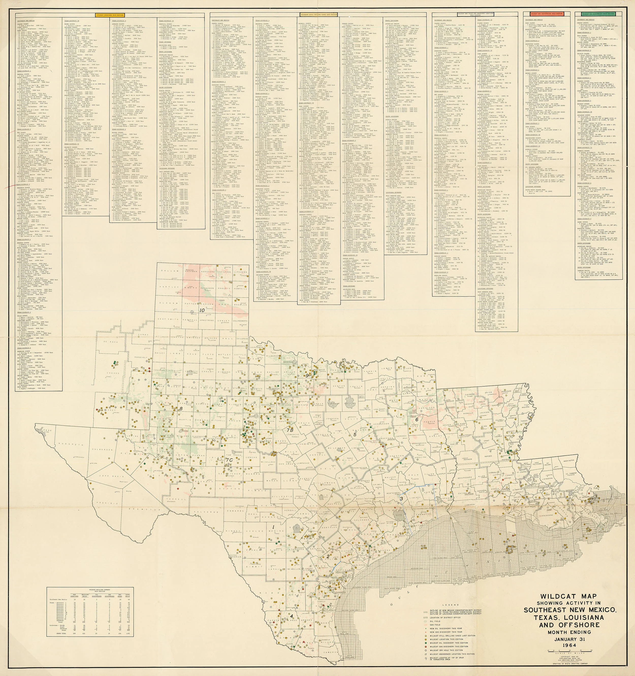
Wildcat map showing oil and gas production of Texas, Louisiana, and part of southern New Mexico. Also shows offshore wells in the Gulf of Mexico. Upper register features a highly detailed index of wells organized by county. A key near the bottom margin indicates:
- Outline of New Mexico Conservation Dept. District
- Outline of Texas Railroad Commission District
- Outline of Louisiana Conservation Dept. District
- Location of District Office
- Oil Field
- Gas Field
- New Oil Discovery This Year
- New Gas Discovery This Year
- Wildcat Still Drilling Since Last Edition
- Wildcat Location This Edition
- Wildcat Oil Discovery This Edition
- Wildcat Gas Discovery This Edition
- Wildcat Dry Hole This Edition
- Wildcat Abandoned Location This Edition
- Wildcat Located at Tip of Spur in Congested Area
- Title: Wildcat Map Showing Activity in Southeast New Mexico, Texas, Louisiana, and Offshore
- Author: Exploration Data, Inc.
- Date: 1964
- Medium: Chromolithograph
- Condition: Excellent - light age toning, issued folding
- Inches: 33 5/8 x 35 3/4 [Paper]
- Centimeters: 85.41 x 90.81 [Paper]
- Product ID: 319040
Wildcat map showing oil and gas production of Texas, Louisiana, and part of southern New Mexico. Also shows offshore wells in the Gulf of Mexico. Upper register features a highly detailed index of wells organized by county. A key near the bottom margin indicates:
- Outline of New Mexico Conservation Dept. District
- Outline of Texas Railroad Commission District
- Outline of Louisiana Conservation Dept. District
- Location of District Office
- Oil Field
- Gas Field
- New Oil Discovery This Year
- New Gas Discovery This Year
- Wildcat Still Drilling Since Last Edition
- Wildcat Location This Edition
- Wildcat Oil Discovery This Edition
- Wildcat Gas Discovery This Edition
- Wildcat Dry Hole This Edition
- Wildcat Abandoned Location This Edition
- Wildcat Located at Tip of Spur in Congested Area
Original: $895.00
-65%$895.00
$313.25Description
- Title: Wildcat Map Showing Activity in Southeast New Mexico, Texas, Louisiana, and Offshore
- Author: Exploration Data, Inc.
- Date: 1964
- Medium: Chromolithograph
- Condition: Excellent - light age toning, issued folding
- Inches: 33 5/8 x 35 3/4 [Paper]
- Centimeters: 85.41 x 90.81 [Paper]
- Product ID: 319040
Wildcat map showing oil and gas production of Texas, Louisiana, and part of southern New Mexico. Also shows offshore wells in the Gulf of Mexico. Upper register features a highly detailed index of wells organized by county. A key near the bottom margin indicates:
- Outline of New Mexico Conservation Dept. District
- Outline of Texas Railroad Commission District
- Outline of Louisiana Conservation Dept. District
- Location of District Office
- Oil Field
- Gas Field
- New Oil Discovery This Year
- New Gas Discovery This Year
- Wildcat Still Drilling Since Last Edition
- Wildcat Location This Edition
- Wildcat Oil Discovery This Edition
- Wildcat Gas Discovery This Edition
- Wildcat Dry Hole This Edition
- Wildcat Abandoned Location This Edition
- Wildcat Located at Tip of Spur in Congested Area